Property Record
4115 Meadows Dr, Indianapolis, IN 46205

NEARBY LISTINGS FOR SALE OR LEASE
Property Detail
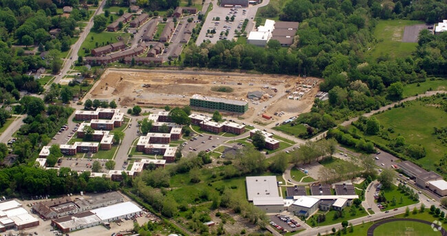
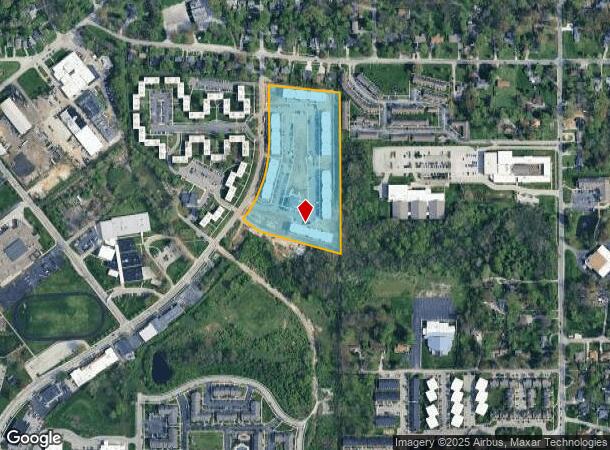
4115 Meadows Dr
Indianapolis
West Village At Avondale Meadows
Indianapolis-Carmel-Anderson, IN
WEST VILLAGE AT AVONDALE MEADOWS L2
49-07-17-125-024.001-801
Marion
Apartment
Indiana
2023
2
2024
9.91 AC
322601
Meadows
2,142 SF
DEMOGRAPHICS near 4115 Meadows Dr
1 Mile
3 Mile
5 Mile
2024 Total Population
10,383
101,993
272,181
2029 Population
10,445
102,240
272,944
Pop Growth 2024-2029
+ 0.60%
+ 0.24%
+ 0.28%
Average Age
39
38
38
2024 Total Households
4,723
44,461
119,724
HH Growth 2024-2029
+ 0.40%
+ 0.04%
+ 0.19%
Median Household Inc
$38,792
$52,265
$55,213
Avg Household Size
2.20
2.20
2.20
2024 Avg HH Vehicles
1.00
2.00
2.00
Median Home Value
$137,088
$210,354
$216,856
Median Year Built
1963
1955
1956
Nearby Places
Map Layers
Map Styles
 Street
 Aerial
- Restaurants
- Banks
- Shops
- Fitness
- Groceries
PUBLIC TRANSPORTATION
COMMUTER RAIL
Indianapolis (Cardinal - Amtrak)
DRIVE
WALK
Distance
Indianapolis (Cardinal - Amtrak)
13 min
7.1 mi
AIRPORT
Indianapolis International
DRIVE
WALK
Distance
Indianapolis International
35 min
20.1 mi
Freight Ports
Port of Toledo
DRIVE
WALK
Distance
Port of Toledo
261 min
219.6 mi
Nearby Properties
Address
Land Use
TOTAL SIZE
Lot Size
Zoning
Address
Land Use
TOTAL SIZE
Lot Size
Zoning
143,890 SF
37.81 AC
ZO01
Address
Land Use
TOTAL SIZE
Lot Size
Zoning
866 SF
14.33 AC
ZO01
Address
Land Use
TOTAL SIZE
Lot Size
Zoning
76,657 SF
9.45 AC
ZO01
Address
Land Use
TOTAL SIZE
Lot Size
Zoning
2.81 AC
ZO01
Address
Land Use
TOTAL SIZE
Lot Size
Zoning
13,789 SF
3.93 AC
ZO01
Address
Land Use
TOTAL SIZE
Lot Size
Zoning
5,670 SF
25.69 AC
Address
Land Use
TOTAL SIZE
Lot Size
Zoning
1,903 SF
20.77 AC
ZO01
Address
Land Use
TOTAL SIZE
Lot Size
Zoning
7,740 SF
2.04 AC
ZO01
Address
Land Use
TOTAL SIZE
Lot Size
Zoning
2,951 SF
15.45 AC
ZO01
Address
Land Use
TOTAL SIZE
Lot Size
Zoning
66,953 SF
10.87 AC
ZO01
Address
Land Use
TOTAL SIZE
Lot Size
Zoning
17,621 SF
3.20 AC
ZO01
Address
Land Use
TOTAL SIZE
Lot Size
Zoning
4,692 SF
25.76 AC
Address
Land Use
TOTAL SIZE
Lot Size
Zoning
2,927 SF
8.75 AC
ZO01
Address
Land Use
TOTAL SIZE
Lot Size
Zoning
156,720 SF
6.18 AC
ZO01
Address
Land Use
TOTAL SIZE
Lot Size
Zoning
10,006 SF
8.89 AC
ZO01
Address
Land Use
TOTAL SIZE
Lot Size
Zoning
194,158 SF
19.29 AC
ZO01
Address
Land Use
TOTAL SIZE
Lot Size
Zoning
6,252 SF
17.02 AC
ZO01
Address
Land Use
TOTAL SIZE
Lot Size
Zoning
6.53 AC
ZO01
Address
Land Use
TOTAL SIZE
Lot Size
Zoning
23,686 SF
8.57 AC
ZO01
Address
Land Use
TOTAL SIZE
Lot Size
Zoning
3,920 SF
26.08 AC
ZO01
Address
Land Use
TOTAL SIZE
Lot Size
Zoning
1,962 SF
8.66 AC
ZO01
Address
Land Use
TOTAL SIZE
Lot Size
Zoning
55,047 SF
2.01 AC
ZO01
Address
Land Use
TOTAL SIZE
Lot Size
Zoning
1,340 SF
1.70 AC
Address
Land Use
TOTAL SIZE
Lot Size
Zoning
154,816 SF
8.69 AC
ZO01
Address
Land Use
TOTAL SIZE
Lot Size
Zoning
14,482 SF
8.89 AC
ZO01
Address
Land Use
TOTAL SIZE
Lot Size
Zoning
520,902 SF
17.92 AC
ZO01
Address
Land Use
TOTAL SIZE
Lot Size
Zoning
3,411 SF
21.69 AC
ZO01
Address
Land Use
TOTAL SIZE
Lot Size
Zoning
44,164 SF
1.30 AC
ZO01
Address
Land Use
TOTAL SIZE
Lot Size
Zoning
1,696 SF
9.96 AC
ZO01
The World's #1 Commercial Real Estate Marketplace
Connect with us
© 2026 CoStar Group
The information above has been obtained from sources believed reliable. While we do not doubt its accuracy we have not verified it and make no guarantee, warranty or representation about it. It is your responsibility to independently confirm its accuracy and completeness. Any projections, opinions, assumptions, or estimates used are for example only and do not represent the current or future performance of the property. The value of this transaction to you depends on tax and other factors which should be evaluated by your tax, financial, and legal advisors. You and your advisors should conduct a careful, independent investigation of the property to determine to your satisfaction the suitability of the property for your needs.