Property Record
4115 N Kings Hwy N, Texarkana, TX 75503
NEARBY LISTINGS FOR SALE OR LEASE
-
-
No Photo
-
-
-
View all Texarkana listings for lease on LoopNet.com
Property Detail
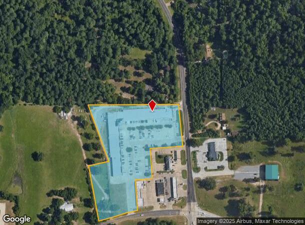
4115 N Kings Hwy N
5417
George Brinlee A-18
Commercialnec
GEORGE BRINLEE A-18 4926/133 06/29/06 BLK/TRACT 388 388A 5.659 ACRES
X
Bowie
48037C0350E
Texas
2024
5.66 AC
2025
Texas East Area
010906
Other Market Areas
44,052 SF
Texarkana, TX-AR
DEMOGRAPHICS near 4115 N Kings Hwy N
1 Mile
3 Mile
5 Mile
2024 Total Population
2,459
23,630
50,436
2029 Population
2,452
23,508
50,440
Pop Growth 2024-2029
(0.28%)
(0.52%)
+ 0.01%
Average Age
37
39
39
2024 Total Households
967
9,422
20,253
HH Growth 2024-2029
(0.31%)
(0.55%)
+ 0.01%
Median Household Inc
$57,900
$59,306
$53,161
Avg Household Size
2.50
2.40
2.40
2024 Avg HH Vehicles
2.00
2.00
2.00
Median Home Value
$166,384
$172,510
$164,519
Median Year Built
1997
1988
1985
Nearby Places
Map Layers
Map Styles
 Street
 Aerial
- Restaurants
- Banks
- Shops
- Fitness
- Groceries
PUBLIC TRANSPORTATION
COMMUTER RAIL
Texarkana Amtrak Station (Texas Eagle - Amtrak)
DRIVE
WALK
Distance
Texarkana Amtrak Station (Texas Eagle - Amtrak)
12 min
7.0 mi
AIRPORT
Texarkana Regional-Webb Field
DRIVE
WALK
Distance
Texarkana Regional-Webb Field
20 min
12.0 mi
Freight Ports
Port of Shreveport
DRIVE
WALK
Distance
Port of Shreveport
114 min
100.0 mi
SALE & LEASE HISTORY
LISTING DATE
SALE/LEASE

Sep 25, 2016
For Lease
May 09, 2023
For Lease
Mar 16, 2017
For Lease
Feb 08, 2022
For Lease
Nearby Properties
Address
Land Use
TOTAL SIZE
Lot Size
Zoning
Address
Land Use
TOTAL SIZE
Lot Size
Zoning
415,000 SF
56.08 AC
Address
Land Use
TOTAL SIZE
Lot Size
Zoning
Address
Land Use
TOTAL SIZE
Lot Size
Zoning
246,136 SF
15.50 AC
Address
Land Use
TOTAL SIZE
Lot Size
Zoning
155,401 SF
15.01 AC
Address
Land Use
TOTAL SIZE
Lot Size
Zoning
130,000 SF
10.18 AC
Address
Land Use
TOTAL SIZE
Lot Size
Zoning
67,800 SF
14.99 AC
Address
Land Use
TOTAL SIZE
Lot Size
Zoning
101,354 SF
33.83 AC
Address
Land Use
TOTAL SIZE
Lot Size
Zoning
533,299 SF
50.60 AC
Address
Land Use
TOTAL SIZE
Lot Size
Zoning
107,400 SF
5.83 AC
Address
Land Use
TOTAL SIZE
Lot Size
Zoning
166,777 SF
9 AC
Address
Land Use
TOTAL SIZE
Lot Size
Zoning
87,452 SF
2.32 AC
Address
Land Use
TOTAL SIZE
Lot Size
Zoning
190,026 SF
30.86 AC
Address
Land Use
TOTAL SIZE
Lot Size
Zoning
62,256 SF
9.67 AC
Address
Land Use
TOTAL SIZE
Lot Size
Zoning
101,980 SF
5 AC
Address
Land Use
TOTAL SIZE
Lot Size
Zoning
82,125 SF
13.71 AC
Address
Land Use
TOTAL SIZE
Lot Size
Zoning
18.64 AC
Address
Land Use
TOTAL SIZE
Lot Size
Zoning
12,449 SF
9.50 AC
Address
Land Use
TOTAL SIZE
Lot Size
Zoning
165,001 SF
26.11 AC
Address
Land Use
TOTAL SIZE
Lot Size
Zoning
175,650 SF
15.56 AC
Address
Land Use
TOTAL SIZE
Lot Size
Zoning
116,386 SF
8.93 AC
Address
Land Use
TOTAL SIZE
Lot Size
Zoning
125,400 SF
9.47 AC
Address
Land Use
TOTAL SIZE
Lot Size
Zoning
89,848 SF
7.15 AC
Address
Land Use
TOTAL SIZE
Lot Size
Zoning
68,816 SF
3.50 AC
Address
Land Use
TOTAL SIZE
Lot Size
Zoning
96,827 SF
11.16 AC
Address
Land Use
TOTAL SIZE
Lot Size
Zoning
70,448 SF
7.61 AC
Address
Land Use
TOTAL SIZE
Lot Size
Zoning
152,914 SF
7.69 AC
Address
Land Use
TOTAL SIZE
Lot Size
Zoning
126,542 SF
14.59 AC
Address
Land Use
TOTAL SIZE
Lot Size
Zoning
65,246 SF
9.36 AC
Address
Land Use
TOTAL SIZE
Lot Size
Zoning
122,640 SF
18.68 AC
Address
Land Use
TOTAL SIZE
Lot Size
Zoning
55,000 SF
6.36 AC
The World's #1 Commercial Real Estate Marketplace
Connect with us
© 2026 CoStar Group
The information above has been obtained from sources believed reliable. While we do not doubt its accuracy we have not verified it and make no guarantee, warranty or representation about it. It is your responsibility to independently confirm its accuracy and completeness. Any projections, opinions, assumptions, or estimates used are for example only and do not represent the current or future performance of the property. The value of this transaction to you depends on tax and other factors which should be evaluated by your tax, financial, and legal advisors. You and your advisors should conduct a careful, independent investigation of the property to determine to your satisfaction the suitability of the property for your needs.