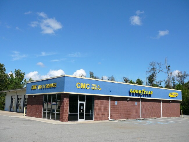
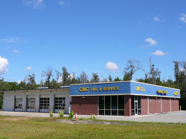
Property Record
4119 Bemiss Rd, Valdosta, GA 31605
NEARBY LISTINGS FOR SALE OR LEASE
Property Detail
4119 Bemiss Rd
Valdosta, GA
Bemiss Comm Central
0146A-094H
Lowndes
Autorepair
Georgia
X
1.14 AC
13185C0120E
Valdosta/Lake Park
10,512 SF
Other Market Areas
DEMOGRAPHICS near 4119 Bemiss Rd
1 Mile
3 Mile
5 Mile
2024 Total Population
3,302
27,105
57,742
2029 Population
3,429
28,098
59,873
Pop Growth 2024-2029
+ 3.85%
+ 3.66%
+ 3.69%
Average Age
34
35
35
2024 Total Households
1,229
10,477
21,918
HH Growth 2024-2029
+ 3.91%
+ 3.74%
+ 3.82%
Median Household Inc
$58,545
$48,344
$47,028
Avg Household Size
2.70
2.50
2.50
2024 Avg HH Vehicles
2.00
2.00
2.00
Median Home Value
$191,144
$183,896
$178,331
Median Year Built
2000
1997
1992
Nearby Places
Map Layers
Map Styles
 Street
 Aerial
- Restaurants
- Banks
- Shops
- Fitness
- Groceries
PUBLIC TRANSPORTATION
AIRPORT
Valdosta Regional
DRIVE
WALK
Distance
Valdosta Regional
18 min
9.5 mi
SALE & LEASE HISTORY
LISTING DATE
SALE/LEASE

Sep 23, 2016
For Sale
Nearby Properties
Address
Land Use
TOTAL SIZE
Lot Size
Zoning
Address
Land Use
TOTAL SIZE
Lot Size
Zoning
39,024 SF
18.04 AC
P-D
Address
Land Use
TOTAL SIZE
Lot Size
Zoning
4,878 SF
14.83 AC
R-P
Address
Land Use
TOTAL SIZE
Lot Size
Zoning
19,825 SF
16.93 AC
R-M
Address
Land Use
TOTAL SIZE
Lot Size
Zoning
2,574 SF
12 AC
R-P
Address
Land Use
TOTAL SIZE
Lot Size
Zoning
185,727 SF
20.33 AC
C-H
Address
Land Use
TOTAL SIZE
Lot Size
Zoning
24,928 SF
10 AC
R-M
Address
Land Use
TOTAL SIZE
Lot Size
Zoning
65,664 SF
16.06 AC
R-M
Address
Land Use
TOTAL SIZE
Lot Size
Zoning
53,880 SF
8.01 AC
C-H,C-C
Address
Land Use
TOTAL SIZE
Lot Size
Zoning
13,056 SF
9.41 AC
R-M
Address
Land Use
TOTAL SIZE
Lot Size
Zoning
2,096 SF
6.98 AC
P-D
Address
Land Use
TOTAL SIZE
Lot Size
Zoning
1,902 SF
10.58 AC
R-M
Address
Land Use
TOTAL SIZE
Lot Size
Zoning
49,546 SF
10.45 AC
R-P
Address
Land Use
TOTAL SIZE
Lot Size
Zoning
202,062 SF
7.12 AC
R-15
Address
Land Use
TOTAL SIZE
Lot Size
Zoning
25,727 SF
9.12 AC
R-A
Address
Land Use
TOTAL SIZE
Lot Size
Zoning
9,180 SF
4.86 AC
C-H
Address
Land Use
TOTAL SIZE
Lot Size
Zoning
1,260 SF
8.21 AC
C-H
Address
Land Use
TOTAL SIZE
Lot Size
Zoning
22,906 SF
3.25 AC
C-C
Address
Land Use
TOTAL SIZE
Lot Size
Zoning
0.27 AC
C-C
Address
Land Use
TOTAL SIZE
Lot Size
Zoning
40,343 SF
49.11 AC
R-6
Address
Land Use
TOTAL SIZE
Lot Size
Zoning
66.89 AC
C-H
Address
Land Use
TOTAL SIZE
Lot Size
Zoning
3,360 SF
7.41 AC
C-G
Address
Land Use
TOTAL SIZE
Lot Size
Zoning
40,932 SF
9.77 AC
C-H,PCD
Address
Land Use
TOTAL SIZE
Lot Size
Zoning
15,343 SF
7 AC
C-C
Address
Land Use
TOTAL SIZE
Lot Size
Zoning
1,824 SF
3.60 AC
P-D
Address
Land Use
TOTAL SIZE
Lot Size
Zoning
3,274 SF
2.63 AC
P-D
Address
Land Use
TOTAL SIZE
Lot Size
Zoning
4,816 SF
2.82 AC
C-H
Address
Land Use
TOTAL SIZE
Lot Size
Zoning
19,262 SF
3.27 AC
R-10
Address
Land Use
TOTAL SIZE
Lot Size
Zoning
3,552 SF
3.03 AC
R-P
Address
Land Use
TOTAL SIZE
Lot Size
Zoning
33,695 SF
5.84 AC
C-G
Address
Land Use
TOTAL SIZE
Lot Size
Zoning
41,952 SF
1.38 AC
P-D
The World's #1 Commercial Real Estate Marketplace
Connect with us
© 2026 CoStar Group
The information above has been obtained from sources believed reliable. While we do not doubt its accuracy we have not verified it and make no guarantee, warranty or representation about it. It is your responsibility to independently confirm its accuracy and completeness. Any projections, opinions, assumptions, or estimates used are for example only and do not represent the current or future performance of the property. The value of this transaction to you depends on tax and other factors which should be evaluated by your tax, financial, and legal advisors. You and your advisors should conduct a careful, independent investigation of the property to determine to your satisfaction the suitability of the property for your needs.