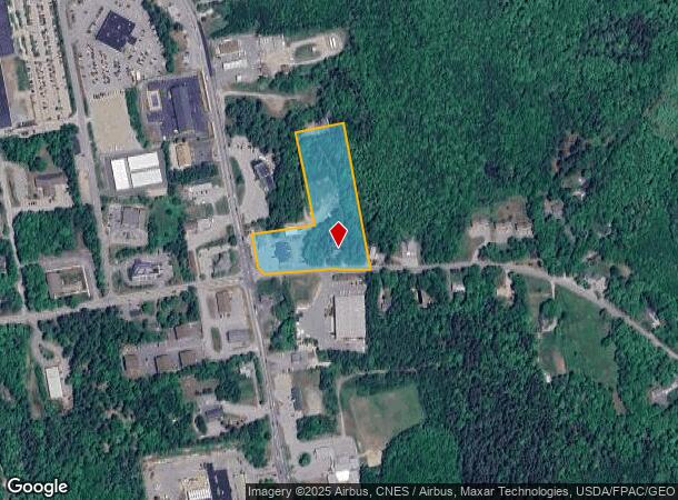
Property Record
18 Buttermilk Rd, Lamoine, ME 04605

Current Lease Availabilities
NEARBY LISTINGS FOR SALE OR LEASE
-
-
View all Lamoine listings for lease on LoopNet.com
Property Detail
18 Buttermilk Rd
ELLH-000016-000059-000000-000000-B1060R
Hancock
Duplex
Maine
X
3.48 AC
23009C0769D
Maine North & Bangor
2,156 SF
Other Market Areas
DEMOGRAPHICS near 18 Buttermilk Rd
1 Mile
3 Mile
5 Mile
2024 Total Population
409
5,831
8,626
2029 Population
421
5,919
8,767
Pop Growth 2024-2029
+ 2.93%
+ 1.51%
+ 1.63%
Average Age
44
44
44
2024 Total Households
192
2,648
3,870
HH Growth 2024-2029
+ 2.60%
+ 1.55%
+ 1.68%
Median Household Inc
$62,857
$74,106
$73,816
Avg Household Size
2.00
2.10
2.10
2024 Avg HH Vehicles
1.00
2.00
2.00
Median Home Value
$299,999
$255,940
$269,380
Median Year Built
1995
1985
1986
Nearby Places
- Restaurants
- Banks
- Shops
- Fitness
- Groceries
PUBLIC TRANSPORTATION
AIRPORT
Bangor International
DRIVE
WALK
Distance
Bangor International
55 min
33.6 mi
Freight Ports
Searsport, ME
DRIVE
WALK
Distance
Searsport, ME
53 min
33.7 mi
Nearby Properties
Address
Land Use
TOTAL SIZE
Lot Size
Zoning
Address
Land Use
TOTAL SIZE
Lot Size
Zoning
Address
Land Use
TOTAL SIZE
Lot Size
Zoning
Address
Land Use
TOTAL SIZE
Lot Size
Zoning
194,760 SF
21.13 AC
CTDD
Address
Land Use
TOTAL SIZE
Lot Size
Zoning
14,581 SF
3.14 AC
DTT
Address
Land Use
TOTAL SIZE
Lot Size
Zoning
114,925 SF
13.68 AC
CTDD
Address
Land Use
TOTAL SIZE
Lot Size
Zoning
5 AC
EHNG
Address
Land Use
TOTAL SIZE
Lot Size
Zoning
52,584 SF
27.38 AC
CDD
Address
Land Use
TOTAL SIZE
Lot Size
Zoning
40,250 SF
10.96 AC
UDT
Address
Land Use
TOTAL SIZE
Lot Size
Zoning
14,092 SF
3 AC
CDD
Address
Land Use
TOTAL SIZE
Lot Size
Zoning
13.76 AC
N
Address
Land Use
TOTAL SIZE
Lot Size
Zoning
4.67 AC
U
Address
Land Use
TOTAL SIZE
Lot Size
Zoning
12,805 SF
5.17 AC
ESC
Address
Land Use
TOTAL SIZE
Lot Size
Zoning
0.50 AC
Address
Land Use
TOTAL SIZE
Lot Size
Zoning
919 SF
CDD
Address
Land Use
TOTAL SIZE
Lot Size
Zoning
93,169 SF
13.56 AC
CDD
Address
Land Use
TOTAL SIZE
Lot Size
Zoning
5,016 SF
2.95 AC
U
Address
Land Use
TOTAL SIZE
Lot Size
Zoning
60,708 SF
9.26 AC
U
Address
Land Use
TOTAL SIZE
Lot Size
Zoning
11,416 SF
0.37 AC
U
Address
Land Use
TOTAL SIZE
Lot Size
Zoning
7,798 SF
0.49 AC
GDDT
Address
Land Use
TOTAL SIZE
Lot Size
Zoning
22,960 SF
5.69 AC
CTDD
Address
Land Use
TOTAL SIZE
Lot Size
Zoning
Address
Land Use
TOTAL SIZE
Lot Size
Zoning
3.16 AC
DT
Address
Land Use
TOTAL SIZE
Lot Size
Zoning
10,846 SF
2.78 AC
DTT
Address
Land Use
TOTAL SIZE
Lot Size
Zoning
19,152 SF
4.50 AC
DT
Address
Land Use
TOTAL SIZE
Lot Size
Zoning
2,994 SF
1.68 AC
CDD
Address
Land Use
TOTAL SIZE
Lot Size
Zoning
2.20 AC
CDD
Address
Land Use
TOTAL SIZE
Lot Size
Zoning
13,333 SF
1.77 AC
U
Address
Land Use
TOTAL SIZE
Lot Size
Zoning
1.82 AC
CDD
Address
Land Use
TOTAL SIZE
Lot Size
Zoning
26,921 SF
8.31 AC
CDD
Address
Land Use
TOTAL SIZE
Lot Size
Zoning
14,818 SF
2.22 AC
CDD
The World's #1 Commercial Real Estate Marketplace
Connect with us
© 2025 CoStar Group
The information above has been obtained from sources believed reliable. While we do not doubt its accuracy we have not verified it and make no guarantee, warranty or representation about it. It is your responsibility to independently confirm its accuracy and completeness. Any projections, opinions, assumptions, or estimates used are for example only and do not represent the current or future performance of the property. The value of this transaction to you depends on tax and other factors which should be evaluated by your tax, financial, and legal advisors. You and your advisors should conduct a careful, independent investigation of the property to determine to your satisfaction the suitability of the property for your needs.