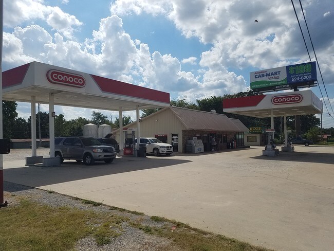
Property Record
412 Highway, Colcord, OK 74338

Property Detail
412 Highway
0001084
31-20-26 PT NW DESCRIBED AS: BEG NW COR NE NW; E 253'; S 148.07'; W 253'; N 145.79' TO BEG & BEG 145.79' S OF NW COR NE NW; S
Conveniencestore
DELAWARE
B and X Area of moderate flood hazard, usually the area between the limits of the 100-year and 500-year floods.
Oklahoma
2025
0.90 AC
2025
Oklahoma East Area
976200
Other Market Areas
2,687 SF
NEARBY LISTINGS FOR SALE OR LEASE
DEMOGRAPHICS near 412 Highway
1 mile
3 mile
5 mile
2025 Total Population
1,303
17,107
26,337
2030 Population
1,360
18,771
29,005
Pop Growth 2025-2030
+ 4.37%
+ 9.73%
+ 10.13%
Average Age
37
36
37
2025 Total Households
439
5,884
9,187
HH Growth 2025-2030
+ 4.10%
+ 9.96%
+ 10.35%
Median Household Inc
$54,843
$68,059
$68,688
Avg Household Size
2.60
2.70
2.70
2025 Avg HH Vehicles
2.00
2.00
2.00
Median Home Value
$194,999
$252,287
$252,828
Median Year Built
1984
1991
1994
Nearby Places
Map Layers
Map Styles
 Street
 Aerial
Layers
 Traffic
 Biking
Places
Listings with unknown addresses are not visible on the map
- Restaurants
- Banks
- Shops
- Fitness
- Groceries
PUBLIC TRANSPORTATION
AIRPORT
Northwest Arkansas Ntl
Drive
Walk
Distance
Northwest Arkansas Ntl
45 min
24.7 mi
Freight Ports
Tulsa Port of Inola
Drive
Walk
Distance
Tulsa Port of Inola
66 min
60.8 mi
SALE & LEASE HISTORY
LISTING DATE
SALE/LEASE

Sep 20, 2018
For Sale
Nearby Properties
Address
Land Use
TOTAL SIZE
Lot Size
Zoning
Address
Land Use
TOTAL SIZE
Lot Size
Zoning
85,903 SF
10 AC
Address
Land Use
TOTAL SIZE
Lot Size
Zoning
190,712 SF
15.73 AC
Address
Land Use
TOTAL SIZE
Lot Size
Zoning
119,258 SF
16.25 AC
Address
Land Use
TOTAL SIZE
Lot Size
Zoning
53,071 SF
2.07 AC
Address
Land Use
TOTAL SIZE
Lot Size
Zoning
264,685 SF
14.13 AC
Address
Land Use
TOTAL SIZE
Lot Size
Zoning
98,492 SF
6.33 AC
Address
Land Use
TOTAL SIZE
Lot Size
Zoning
20,475 SF
19.62 AC
Address
Land Use
TOTAL SIZE
Lot Size
Zoning
92,300 SF
6.35 AC
Address
Land Use
TOTAL SIZE
Lot Size
Zoning
144,166 SF
12.49 AC
Address
Land Use
TOTAL SIZE
Lot Size
Zoning
36,185 SF
0.78 AC
Address
Land Use
TOTAL SIZE
Lot Size
Zoning
41,748 SF
5.44 AC
Address
Land Use
TOTAL SIZE
Lot Size
Zoning
20,714 SF
0.57 AC
Address
Land Use
TOTAL SIZE
Lot Size
Zoning
40,709 SF
4.24 AC
Address
Land Use
TOTAL SIZE
Lot Size
Zoning
21,908 SF
6.44 AC
Address
Land Use
TOTAL SIZE
Lot Size
Zoning
244,674 SF
18.51 AC
Address
Land Use
TOTAL SIZE
Lot Size
Zoning
64,710 SF
2.32 AC
Address
Land Use
TOTAL SIZE
Lot Size
Zoning
59,140 SF
4.38 AC
Address
Land Use
TOTAL SIZE
Lot Size
Zoning
69,878 SF
3.69 AC
Address
Land Use
TOTAL SIZE
Lot Size
Zoning
20,484 SF
0.93 AC
Address
Land Use
TOTAL SIZE
Lot Size
Zoning
23,918 SF
1.95 AC
Address
Land Use
TOTAL SIZE
Lot Size
Zoning
16,250 SF
4.57 AC
Address
Land Use
TOTAL SIZE
Lot Size
Zoning
36,126 SF
1.97 AC
Address
Land Use
TOTAL SIZE
Lot Size
Zoning
117,300 SF
7.27 AC
Address
Land Use
TOTAL SIZE
Lot Size
Zoning
7,160 SF
2.05 AC
Address
Land Use
TOTAL SIZE
Lot Size
Zoning
88,576 SF
4.45 AC
Address
Land Use
TOTAL SIZE
Lot Size
Zoning
46,882 SF
7.62 AC
Address
Land Use
TOTAL SIZE
Lot Size
Zoning
6,547 SF
2.19 AC
Address
Land Use
TOTAL SIZE
Lot Size
Zoning
19,395 SF
2.21 AC
Address
Land Use
TOTAL SIZE
Lot Size
Zoning
5,650 SF
0.18 AC
Address
Land Use
TOTAL SIZE
Lot Size
Zoning
2,548 SF
4 AC
The World's #1 Commercial Real Estate Marketplace
Connect with us
© 2026 CoStar Group
The information above has been obtained from sources believed reliable. While we do not doubt its accuracy we have not verified it and make no guarantee, warranty or representation about it. It is your responsibility to independently confirm its accuracy and completeness. Any projections, opinions, assumptions, or estimates used are for example only and do not represent the current or future performance of the property. The value of this transaction to you depends on tax and other factors which should be evaluated by your tax, financial, and legal advisors. You and your advisors should conduct a careful, independent investigation of the property to determine to your satisfaction the suitability of the property for your needs.