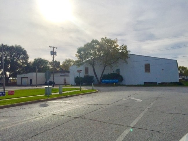
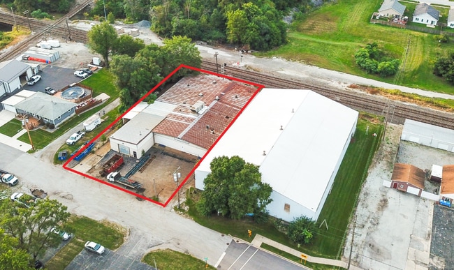
Property Record
412 Matteson St, Dyer, IN 46311

Current Lease Availabilities
NEARBY LISTINGS FOR SALE OR LEASE
Property Detail
412 Matteson St
Chicago-Naperville-Elgin, IL-IN-WI
Hadady Second Addition
45-10-12-407-001.000-034
HADADY SECOND ADDITION LOT 1
Industrialgeneral
Lake
X
Indiana
17197C0385G
1
2024
0.50 AC
2025
Indiana
042803
Chicago
DEMOGRAPHICS near 412 Matteson St
1 Mile
3 Mile
5 Mile
2024 Total Population
7,372
48,414
132,950
2029 Population
7,298
47,947
131,528
Pop Growth 2024-2029
(1.00%)
(0.96%)
(1.07%)
Average Age
42
42
43
2024 Total Households
2,900
18,581
51,689
HH Growth 2024-2029
(1.10%)
(1.07%)
(1.19%)
Median Household Inc
$79,151
$82,986
$82,457
Avg Household Size
2.50
2.50
2.50
2024 Avg HH Vehicles
2.00
2.00
2.00
Median Home Value
$228,557
$255,249
$241,685
Median Year Built
1987
1988
1977
Nearby Places
Map Layers
Map Styles
 Street
 Aerial
- Restaurants
- Banks
- Shops
- Fitness
- Groceries
PUBLIC TRANSPORTATION
COMMUTER RAIL
Dyer Amtrak (Cardinal - Amtrak)
DRIVE
WALK
Distance
Dyer Amtrak (Cardinal - Amtrak)
3 min
1.2 mi
AIRPORT
Chicago Midway International
DRIVE
WALK
Distance
Chicago Midway International
46 min
30.1 mi
Freight Ports
Port Milwaukee
DRIVE
WALK
Distance
Port Milwaukee
149 min
116.3 mi
Nearby Properties
Address
Land Use
TOTAL SIZE
Lot Size
Zoning
Address
Land Use
TOTAL SIZE
Lot Size
Zoning
308,022 SF
31.99 AC
R33
Address
Land Use
TOTAL SIZE
Lot Size
Zoning
552,813 SF
26.48 AC
Address
Land Use
TOTAL SIZE
Lot Size
Zoning
296,588 SF
36.83 AC
R33
Address
Land Use
TOTAL SIZE
Lot Size
Zoning
454,750 SF
21.15 AC
Address
Land Use
TOTAL SIZE
Lot Size
Zoning
143,274 SF
17.90 AC
1116
Address
Land Use
TOTAL SIZE
Lot Size
Zoning
130,558 SF
9.89 AC
R33
Address
Land Use
TOTAL SIZE
Lot Size
Zoning
190,457 SF
10.63 AC
Address
Land Use
TOTAL SIZE
Lot Size
Zoning
668,326 SF
28.87 AC
Address
Land Use
TOTAL SIZE
Lot Size
Zoning
81,622 SF
9.20 AC
Address
Land Use
TOTAL SIZE
Lot Size
Zoning
246,302 SF
13.08 AC
Address
Land Use
TOTAL SIZE
Lot Size
Zoning
90,526 SF
22.99 AC
R33
Address
Land Use
TOTAL SIZE
Lot Size
Zoning
64,855 SF
5 AC
Address
Land Use
TOTAL SIZE
Lot Size
Zoning
70,017 SF
11 AC
R33
Address
Land Use
TOTAL SIZE
Lot Size
Zoning
87,836 SF
14.12 AC
R33
Address
Land Use
TOTAL SIZE
Lot Size
Zoning
134,623 SF
7.08 AC
Address
Land Use
TOTAL SIZE
Lot Size
Zoning
62,026 SF
9.70 AC
Address
Land Use
TOTAL SIZE
Lot Size
Zoning
64,971 SF
6.98 AC
Address
Land Use
TOTAL SIZE
Lot Size
Zoning
66,240 SF
0.45 AC
Address
Land Use
TOTAL SIZE
Lot Size
Zoning
176,859 SF
12.01 AC
R33
Address
Land Use
TOTAL SIZE
Lot Size
Zoning
25,910 SF
2.06 AC
Address
Land Use
TOTAL SIZE
Lot Size
Zoning
119,059 SF
10.12 AC
R33
Address
Land Use
TOTAL SIZE
Lot Size
Zoning
60,992 SF
11.38 AC
R33
Address
Land Use
TOTAL SIZE
Lot Size
Zoning
63,711 SF
6.98 AC
Address
Land Use
TOTAL SIZE
Lot Size
Zoning
158,292 SF
8.20 AC
Address
Land Use
TOTAL SIZE
Lot Size
Zoning
61,214 SF
2.06 AC
Address
Land Use
TOTAL SIZE
Lot Size
Zoning
129,320 SF
3.96 AC
Address
Land Use
TOTAL SIZE
Lot Size
Zoning
134,080 SF
10 AC
Address
Land Use
TOTAL SIZE
Lot Size
Zoning
78,221 SF
6.37 AC
Address
Land Use
TOTAL SIZE
Lot Size
Zoning
119,758 SF
3.80 AC
Address
Land Use
TOTAL SIZE
Lot Size
Zoning
8.27 AC
The World's #1 Commercial Real Estate Marketplace
Connect with us
© 2026 CoStar Group
The information above has been obtained from sources believed reliable. While we do not doubt its accuracy we have not verified it and make no guarantee, warranty or representation about it. It is your responsibility to independently confirm its accuracy and completeness. Any projections, opinions, assumptions, or estimates used are for example only and do not represent the current or future performance of the property. The value of this transaction to you depends on tax and other factors which should be evaluated by your tax, financial, and legal advisors. You and your advisors should conduct a careful, independent investigation of the property to determine to your satisfaction the suitability of the property for your needs.