Property Record
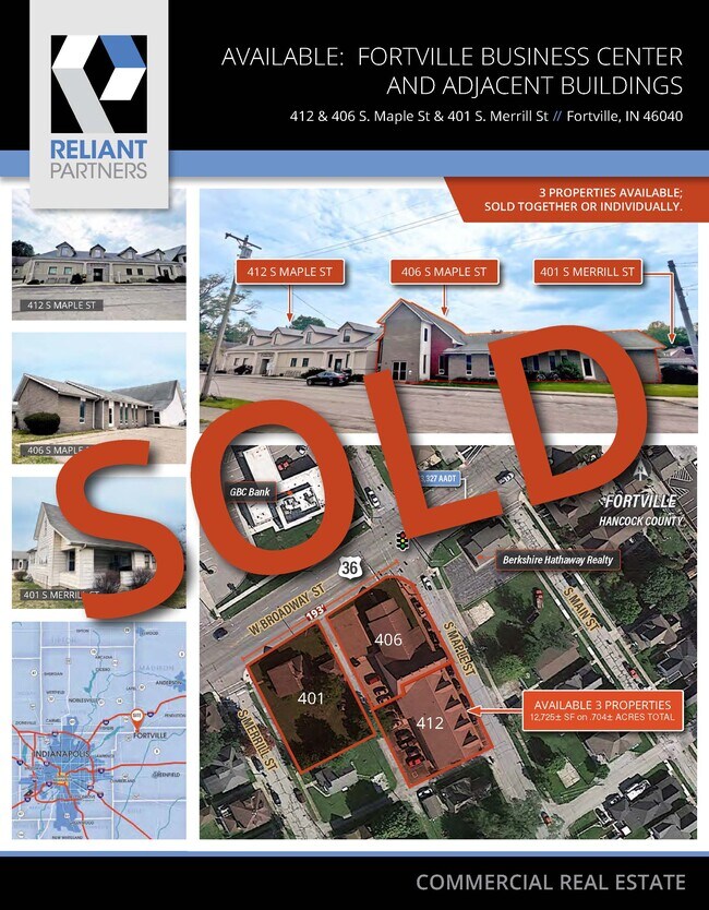
412 S Maple St, Fortville, IN 46040


NEARBY LISTINGS FOR SALE OR LEASE
-
-
View all Fortville listings for sale on LoopNet.com
Property Detail
412 S Maple St
30-02-09-401-006.002-017
J S Merrils Elizabeth Hagans
Officebuilding
MERRILL L2 & PT L1
X
Hancock
18057C0286G
Indiana
2024
0.21 AC
2024
Hancock County
410202
Indianapolis
6,753 SF
Indianapolis-Carmel-Greenwood, IN
DEMOGRAPHICS near 412 S Maple St
1 Mile
3 Mile
5 Mile
2024 Total Population
4,907
17,634
53,033
2029 Population
5,469
19,698
59,419
Pop Growth 2024-2029
+ 11.45%
+ 11.70%
+ 12.04%
Average Age
38
37
38
2024 Total Households
2,023
6,121
18,251
HH Growth 2024-2029
+ 11.62%
+ 11.57%
+ 12.03%
Median Household Inc
$81,714
$98,991
$113,493
Avg Household Size
2.40
2.80
2.90
2024 Avg HH Vehicles
2.00
2.00
2.00
Median Home Value
$211,290
$316,055
$342,475
Median Year Built
1994
2003
2009
Nearby Places
Map Layers
Map Styles
 Street
 Aerial
- Restaurants
- Banks
- Shops
- Fitness
- Groceries
PUBLIC TRANSPORTATION
AIRPORT
Indianapolis International
DRIVE
WALK
Distance
Indianapolis International
50 min
39.0 mi
Freight Ports
Virginia Port Authority - Richmond
DRIVE
WALK
Distance
Virginia Port Authority - Richmond
1 min
485.3 mi
SALE & LEASE HISTORY
LISTING DATE
SALE/LEASE

Sep 09, 2020
For Lease
Oct 12, 2017
For Sale
May 31, 2022
For Lease
Jun 29, 2017
For Lease
Jun 28, 2017
For Sale
Jun 03, 2024
For Sale
Nearby Properties
Address
Land Use
TOTAL SIZE
Lot Size
Zoning
Address
Land Use
TOTAL SIZE
Lot Size
Zoning
1,200 SF
18.67 AC
Address
Land Use
TOTAL SIZE
Lot Size
Zoning
18,512 SF
4.26 AC
Address
Land Use
TOTAL SIZE
Lot Size
Zoning
134,063 SF
14.43 AC
Address
Land Use
TOTAL SIZE
Lot Size
Zoning
78.98 AC
Address
Land Use
TOTAL SIZE
Lot Size
Zoning
6,720 SF
3.35 AC
Address
Land Use
TOTAL SIZE
Lot Size
Zoning
45,000 SF
30.16 AC
Address
Land Use
TOTAL SIZE
Lot Size
Zoning
20,000 SF
9.04 AC
Address
Land Use
TOTAL SIZE
Lot Size
Zoning
5,370 SF
6.97 AC
Address
Land Use
TOTAL SIZE
Lot Size
Zoning
43,039 SF
2.56 AC
Address
Land Use
TOTAL SIZE
Lot Size
Zoning
15,140 SF
2.73 AC
Address
Land Use
TOTAL SIZE
Lot Size
Zoning
1,792 SF
9.96 AC
Address
Land Use
TOTAL SIZE
Lot Size
Zoning
60,406 SF
2.91 AC
Address
Land Use
TOTAL SIZE
Lot Size
Zoning
44,732 SF
1.60 AC
Address
Land Use
TOTAL SIZE
Lot Size
Zoning
46.13 AC
Address
Land Use
TOTAL SIZE
Lot Size
Zoning
9,000 SF
1.74 AC
Address
Land Use
TOTAL SIZE
Lot Size
Zoning
3,900 SF
3.66 AC
Address
Land Use
TOTAL SIZE
Lot Size
Zoning
6,798 SF
3.23 AC
Address
Land Use
TOTAL SIZE
Lot Size
Zoning
8,511 SF
3 AC
Address
Land Use
TOTAL SIZE
Lot Size
Zoning
18,145 SF
18.60 AC
Address
Land Use
TOTAL SIZE
Lot Size
Zoning
10,000 SF
2.94 AC
Address
Land Use
TOTAL SIZE
Lot Size
Zoning
25,763 SF
6.30 AC
Address
Land Use
TOTAL SIZE
Lot Size
Zoning
17,425 SF
2 AC
Address
Land Use
TOTAL SIZE
Lot Size
Zoning
9,219 SF
0.63 AC
Address
Land Use
TOTAL SIZE
Lot Size
Zoning
6,247 SF
0.67 AC
Address
Land Use
TOTAL SIZE
Lot Size
Zoning
3,863 SF
1.42 AC
Address
Land Use
TOTAL SIZE
Lot Size
Zoning
4,038 SF
1.21 AC
Address
Land Use
TOTAL SIZE
Lot Size
Zoning
10,940 SF
2.15 AC
Address
Land Use
TOTAL SIZE
Lot Size
Zoning
3,044 SF
1.02 AC
Address
Land Use
TOTAL SIZE
Lot Size
Zoning
3,945 SF
0.65 AC
Address
Land Use
TOTAL SIZE
Lot Size
Zoning
5,000 SF
3.22 AC
The World's #1 Commercial Real Estate Marketplace
Connect with us
© 2026 CoStar Group
The information above has been obtained from sources believed reliable. While we do not doubt its accuracy we have not verified it and make no guarantee, warranty or representation about it. It is your responsibility to independently confirm its accuracy and completeness. Any projections, opinions, assumptions, or estimates used are for example only and do not represent the current or future performance of the property. The value of this transaction to you depends on tax and other factors which should be evaluated by your tax, financial, and legal advisors. You and your advisors should conduct a careful, independent investigation of the property to determine to your satisfaction the suitability of the property for your needs.