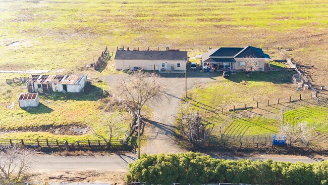
Property Record
4120 Camino Diablo, Byron, CA 94514


Save to a Folder
{{folder.Name}}
{{folder.ListingIds.length}} Properties
{{folder.ListingIds.length}} Property
Create a New Folder
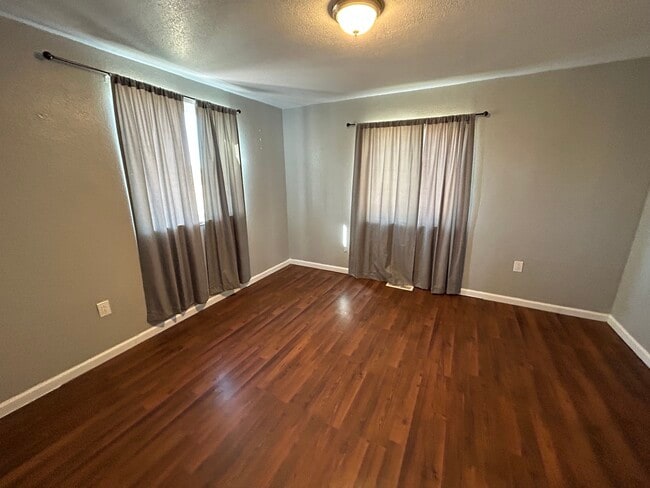
Property Detail
4120 Camino Diablo
002-180-003-2
POR NW 1/4 SEC 11 T1S R3E EX 1/2 MR
Orchard
CONTRA COSTA
A3
California
AE The base floodplain where base flood elevations are provided. AE Zones are now used on new format FIRMs instead of A1-A30 Zones.
128.79 AC
2025
Danville/Alamo
2026
East Bay/Oakland
304002
Oakland-Fremont-Berkeley, CA
1,542 SF
NEARBY LISTINGS FOR SALE OR LEASE
DEMOGRAPHICS near 4120 Camino Diablo
1 mile
3 mile
5 mile
2025 Total Population
196
9,201
18,056
2030 Population
184
9,225
18,223
Pop Growth 2025-2030
(6.12%)
+ 0.26%
+ 0.92%
Average Age
41
45
43
2025 Total Households
64
3,450
6,461
HH Growth 2025-2030
(7.81%)
+ 0.61%
+ 1.18%
Median Household Inc
$74,374
$140,484
$149,932
Avg Household Size
3.00
2.70
2.80
2025 Avg HH Vehicles
3.00
2.00
3.00
Median Home Value
$882,352
$838,813
$800,665
Median Year Built
1976
1991
1994
Nearby Places
Map Layers
Map Styles
 Street
 Aerial
Layers
 Traffic
 Biking
Places
Listings with unknown addresses are not visible on the map
- Restaurants
- Banks
- Shops
- Fitness
- Groceries
PUBLIC TRANSPORTATION
AIRPORT
Stockton Metro
Drive
Walk
Distance
Stockton Metro
44 min
28.3 mi
Freight Ports
Port of Stockton
Drive
Walk
Distance
Port of Stockton
40 min
25.7 mi
SALE & LEASE HISTORY
LISTING DATE
SALE/LEASE

Feb 01, 2023
For Sale
Nearby Properties
Address
Land Use
TOTAL SIZE
Lot Size
Zoning
Address
Land Use
TOTAL SIZE
Lot Size
Zoning
48,000 SF
9.98 AC
P1
Address
Land Use
TOTAL SIZE
Lot Size
Zoning
176.43 AC
A3
Address
Land Use
TOTAL SIZE
Lot Size
Zoning
63,600 SF
8.60 AC
Address
Land Use
TOTAL SIZE
Lot Size
Zoning
2,070 SF
5.82 AC
A2
Address
Land Use
TOTAL SIZE
Lot Size
Zoning
55,183 SF
5.45 AC
P1
Address
Land Use
TOTAL SIZE
Lot Size
Zoning
713.51 AC
P1
Address
Land Use
TOTAL SIZE
Lot Size
Zoning
4,548 SF
3.73 AC
P1
Address
Land Use
TOTAL SIZE
Lot Size
Zoning
14,400 SF
5.99 AC
P1
Address
Land Use
TOTAL SIZE
Lot Size
Zoning
2,964 SF
44 AC
A40
Address
Land Use
TOTAL SIZE
Lot Size
Zoning
28,050 SF
2.71 AC
P1
Address
Land Use
TOTAL SIZE
Lot Size
Zoning
18,469 SF
1.84 AC
P1
Address
Land Use
TOTAL SIZE
Lot Size
Zoning
251.31 AC
A3
Address
Land Use
TOTAL SIZE
Lot Size
Zoning
50 AC
A2
Address
Land Use
TOTAL SIZE
Lot Size
Zoning
10.88 AC
A3
Address
Land Use
TOTAL SIZE
Lot Size
Zoning
4,023 SF
5.40 AC
Address
Land Use
TOTAL SIZE
Lot Size
Zoning
9,075 SF
0.58 AC
P1
Address
Land Use
TOTAL SIZE
Lot Size
Zoning
177.47 AC
A3
Address
Land Use
TOTAL SIZE
Lot Size
Zoning
176.26 AC
A3
Address
Land Use
TOTAL SIZE
Lot Size
Zoning
7,500 SF
0.48 AC
P1
Address
Land Use
TOTAL SIZE
Lot Size
Zoning
8,280 SF
0.56 AC
P1
Address
Land Use
TOTAL SIZE
Lot Size
Zoning
10 AC
A3
Address
Land Use
TOTAL SIZE
Lot Size
Zoning
2,172 SF
47.99 AC
A3
Address
Land Use
TOTAL SIZE
Lot Size
Zoning
11,800 SF
6 AC
P1
Address
Land Use
TOTAL SIZE
Lot Size
Zoning
5,734 SF
10.46 AC
A2
Address
Land Use
TOTAL SIZE
Lot Size
Zoning
6,816 SF
12.29 AC
A40
Address
Land Use
TOTAL SIZE
Lot Size
Zoning
319.93 AC
A3
Address
Land Use
TOTAL SIZE
Lot Size
Zoning
5,172 SF
18.27 AC
A2
Address
Land Use
TOTAL SIZE
Lot Size
Zoning
4.64 AC
P1
Address
Land Use
TOTAL SIZE
Lot Size
Zoning
135.96 AC
A3
Address
Land Use
TOTAL SIZE
Lot Size
Zoning
7,474 SF
25.32 AC
A40
The World's #1 Commercial Real Estate Marketplace
Connect with us
© 2026 CoStar Group
The information above has been obtained from sources believed reliable. While we do not doubt its accuracy we have not verified it and make no guarantee, warranty or representation about it. It is your responsibility to independently confirm its accuracy and completeness. Any projections, opinions, assumptions, or estimates used are for example only and do not represent the current or future performance of the property. The value of this transaction to you depends on tax and other factors which should be evaluated by your tax, financial, and legal advisors. You and your advisors should conduct a careful, independent investigation of the property to determine to your satisfaction the suitability of the property for your needs.