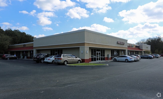
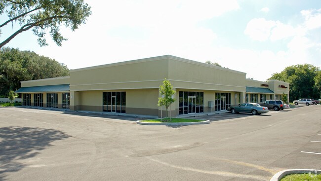
Property Record
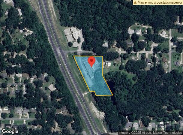
4120 S Corley Island Rd, Leesburg, FL 34748
NEARBY LISTINGS FOR SALE OR LEASE
Property Detail
4120 S Corley Island Rd
02-20-24-0003-000-03409
FROM W 1/4 COR OF SEC RUN S ALONG W LINE OF SAID SEC A DIST OF 913 FT S 89-37-0 E 529.65 FT TO A POINT ON ELY R/W LINE OF US HWY 27 & POB CONT S 89-37-0 E 363.55 FT S 240 FT S 25-26-10 E 255.62 FT N 89-37-0 W 199.64 FT TO A POINT THAT IS S 89-37-0 E
Stripcommercialcenter
Lake
AE
Florida
12069C0320E
34
2024
2.64 AC
2026
Lake County
030701
Orlando
14,430 SF
Orlando-Kissimmee-Sanford, FL
DEMOGRAPHICS near 4120 S Corley Island Rd
1 Mile
3 Mile
5 Mile
2024 Total Population
2,722
22,015
49,409
2029 Population
3,251
26,052
58,102
Pop Growth 2024-2029
+ 19.43%
+ 18.34%
+ 17.59%
Average Age
41
51
51
2024 Total Households
1,141
10,238
22,950
HH Growth 2024-2029
+ 19.19%
+ 18.38%
+ 17.59%
Median Household Inc
$38,565
$48,464
$50,748
Avg Household Size
2.30
2.10
2.10
2024 Avg HH Vehicles
2.00
1.00
1.00
Median Home Value
$142,548
$172,584
$201,911
Median Year Built
1985
1985
1989
Nearby Places
Map Layers
Map Styles
 Street
 Aerial
- Restaurants
- Banks
- Shops
- Fitness
- Groceries
SALE & LEASE HISTORY
LISTING DATE
SALE/LEASE

Sep 25, 2016
For Lease
Nearby Properties
Address
Land Use
TOTAL SIZE
Lot Size
Zoning
Address
Land Use
TOTAL SIZE
Lot Size
Zoning
3,531 SF
23.43 AC
P
Address
Land Use
TOTAL SIZE
Lot Size
Zoning
36,358 SF
276.18 AC
RMRP
Address
Land Use
TOTAL SIZE
Lot Size
Zoning
73,144 SF
75 AC
Address
Land Use
TOTAL SIZE
Lot Size
Zoning
63,584 SF
22.24 AC
PUD
Address
Land Use
TOTAL SIZE
Lot Size
Zoning
46,020 SF
6.11 AC
Address
Land Use
TOTAL SIZE
Lot Size
Zoning
290,514 SF
50.14 AC
PUD
Address
Land Use
TOTAL SIZE
Lot Size
Zoning
2,000 SF
57.83 AC
P
Address
Land Use
TOTAL SIZE
Lot Size
Zoning
299,920 SF
7.45 AC
PUD
Address
Land Use
TOTAL SIZE
Lot Size
Zoning
79,305 SF
17.45 AC
C3
Address
Land Use
TOTAL SIZE
Lot Size
Zoning
96,507 SF
3.45 AC
C1
Address
Land Use
TOTAL SIZE
Lot Size
Zoning
35,820 SF
3.71 AC
R3
Address
Land Use
TOTAL SIZE
Lot Size
Zoning
17,141 SF
113.94 AC
R1
Address
Land Use
TOTAL SIZE
Lot Size
Zoning
147,000 SF
9.04 AC
M1
Address
Land Use
TOTAL SIZE
Lot Size
Zoning
144,336 SF
18.32 AC
R3
Address
Land Use
TOTAL SIZE
Lot Size
Zoning
154,635 SF
11.75 AC
C3
Address
Land Use
TOTAL SIZE
Lot Size
Zoning
61,743 SF
9.79 AC
C3
Address
Land Use
TOTAL SIZE
Lot Size
Zoning
74,035 SF
6.34 AC
M1
Address
Land Use
TOTAL SIZE
Lot Size
Zoning
75,356 SF
8.43 AC
C3
Address
Land Use
TOTAL SIZE
Lot Size
Zoning
60,603 SF
8.40 AC
C3
Address
Land Use
TOTAL SIZE
Lot Size
Zoning
81,060 SF
8.66 AC
C2
Address
Land Use
TOTAL SIZE
Lot Size
Zoning
123,990 SF
19.68 AC
MP
Address
Land Use
TOTAL SIZE
Lot Size
Zoning
59,664 SF
2.33 AC
C3
Address
Land Use
TOTAL SIZE
Lot Size
Zoning
2,000 SF
41.73 AC
R2
Address
Land Use
TOTAL SIZE
Lot Size
Zoning
35,568 SF
2.87 AC
C3
Address
Land Use
TOTAL SIZE
Lot Size
Zoning
15.48 AC
Address
Land Use
TOTAL SIZE
Lot Size
Zoning
63,805 SF
4.25 AC
C2
Address
Land Use
TOTAL SIZE
Lot Size
Zoning
96,236 SF
9.79 AC
HM
Address
Land Use
TOTAL SIZE
Lot Size
Zoning
43,980 SF
0.56 AC
C2
Address
Land Use
TOTAL SIZE
Lot Size
Zoning
96.69 AC
CFD
Address
Land Use
TOTAL SIZE
Lot Size
Zoning
4,888 SF
3.98 AC
RMRP
The World's #1 Commercial Real Estate Marketplace
Connect with us
© 2025 CoStar Group
The information above has been obtained from sources believed reliable. While we do not doubt its accuracy we have not verified it and make no guarantee, warranty or representation about it. It is your responsibility to independently confirm its accuracy and completeness. Any projections, opinions, assumptions, or estimates used are for example only and do not represent the current or future performance of the property. The value of this transaction to you depends on tax and other factors which should be evaluated by your tax, financial, and legal advisors. You and your advisors should conduct a careful, independent investigation of the property to determine to your satisfaction the suitability of the property for your needs.