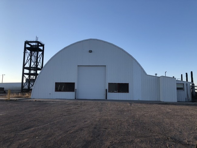
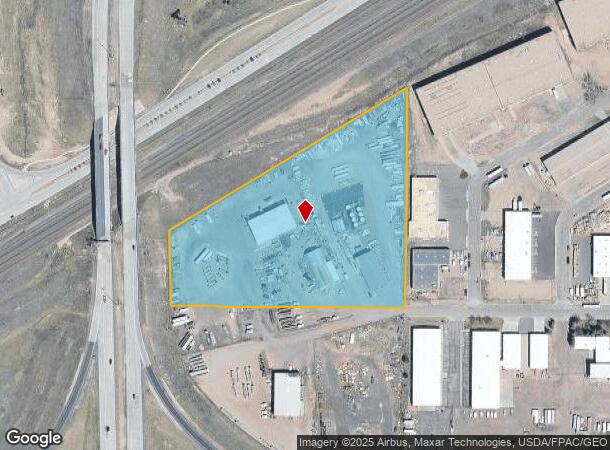
Property Record
4120 W 5Th St, Cheyenne, WY 82007
NEARBY LISTINGS FOR SALE OR LEASE
Property Detail
4120 W 5Th St
0-0013-0067-0201-0
13-67: POR SE1/4 SE1/4 SEC 2, LYING SOUTH OF SOUTH RW OF UPRR, DESC AS: BEG AT SOUTHEAST COR OF SEC 2; TH NORTH ALONG EAST LINE OF SEC 2, 649.6 TO A PNT ON SOUTH R/W LINE OF UPRR; TH S.58 DEG 28W, ALONG SD RW LINE, 1231.8 TO AN INTERSECTION WITH SOUT
Commercialnec
Laramie
X
Wyoming
08123C0025E
7 AC
2024
I-80 Corridor/Cheyenne
2025
Other Market Areas
000200
Cheyenne, WY
6,514 SF
DEMOGRAPHICS near 4120 W 5Th St
1 Mile
3 Mile
5 Mile
2024 Total Population
99
27,186
60,192
2029 Population
100
27,666
61,230
Pop Growth 2024-2029
+ 1.01%
+ 1.77%
+ 1.72%
Average Age
37
38
39
2024 Total Households
38
11,850
25,881
HH Growth 2024-2029
+ 2.63%
+ 1.92%
+ 1.84%
Median Household Inc
$59,166
$47,519
$55,556
Avg Household Size
2.60
2.20
2.20
2024 Avg HH Vehicles
2.00
2.00
2.00
Median Home Value
$246,875
$228,250
$252,845
Median Year Built
1972
1964
1972
Nearby Places
Map Layers
Map Styles
 Street
 Aerial
- Restaurants
- Banks
- Shops
- Fitness
- Groceries
SALE & LEASE HISTORY
LISTING DATE
SALE/LEASE

Jan 03, 2019
For Lease
Nearby Properties
Address
Land Use
TOTAL SIZE
Lot Size
Zoning
Address
Land Use
TOTAL SIZE
Lot Size
Zoning
267,555 SF
50.65 AC
Address
Land Use
TOTAL SIZE
Lot Size
Zoning
373,978 SF
30.24 AC
Address
Land Use
TOTAL SIZE
Lot Size
Zoning
Address
Land Use
TOTAL SIZE
Lot Size
Zoning
934,716 SF
147.40 AC
LI
Address
Land Use
TOTAL SIZE
Lot Size
Zoning
189,952 SF
11.15 AC
HR2
Address
Land Use
TOTAL SIZE
Lot Size
Zoning
Address
Land Use
TOTAL SIZE
Lot Size
Zoning
148,018 SF
Address
Land Use
TOTAL SIZE
Lot Size
Zoning
69,726 SF
0.80 AC
CBD
Address
Land Use
TOTAL SIZE
Lot Size
Zoning
135,427 SF
6.61 AC
Address
Land Use
TOTAL SIZE
Lot Size
Zoning
108,716 SF
12.45 AC
Address
Land Use
TOTAL SIZE
Lot Size
Zoning
69,941 SF
4.31 AC
LI
Address
Land Use
TOTAL SIZE
Lot Size
Zoning
86,860 SF
1.70 AC
CB
Address
Land Use
TOTAL SIZE
Lot Size
Zoning
59,325 SF
0.85 AC
CBD
Address
Land Use
TOTAL SIZE
Lot Size
Zoning
108,332 SF
0.80 AC
MUB
Address
Land Use
TOTAL SIZE
Lot Size
Zoning
225,824 SF
32.58 AC
CB
Address
Land Use
TOTAL SIZE
Lot Size
Zoning
56,724 SF
2.25 AC
Address
Land Use
TOTAL SIZE
Lot Size
Zoning
210,518 SF
20.50 AC
LI
Address
Land Use
TOTAL SIZE
Lot Size
Zoning
71,841 SF
8.11 AC
Address
Land Use
TOTAL SIZE
Lot Size
Zoning
30,024 SF
9.53 AC
Address
Land Use
TOTAL SIZE
Lot Size
Zoning
55,750 SF
1.58 AC
Address
Land Use
TOTAL SIZE
Lot Size
Zoning
56,714 SF
5.69 AC
CB
Address
Land Use
TOTAL SIZE
Lot Size
Zoning
91,109 SF
24.34 AC
LI
Address
Land Use
TOTAL SIZE
Lot Size
Zoning
43,820 SF
4.34 AC
Address
Land Use
TOTAL SIZE
Lot Size
Zoning
58,352 SF
2.28 AC
Address
Land Use
TOTAL SIZE
Lot Size
Zoning
103,144 SF
10.24 AC
LI
Address
Land Use
TOTAL SIZE
Lot Size
Zoning
51,723 SF
2.71 AC
Address
Land Use
TOTAL SIZE
Lot Size
Zoning
116,121 SF
12.45 AC
CB
Address
Land Use
TOTAL SIZE
Lot Size
Zoning
46,094 SF
1.63 AC
CB
Address
Land Use
TOTAL SIZE
Lot Size
Zoning
52,023 SF
2.42 AC
CB
Address
Land Use
TOTAL SIZE
Lot Size
Zoning
25,477 SF
5.37 AC
CB
The World's #1 Commercial Real Estate Marketplace
Connect with us
© 2025 CoStar Group
The information above has been obtained from sources believed reliable. While we do not doubt its accuracy we have not verified it and make no guarantee, warranty or representation about it. It is your responsibility to independently confirm its accuracy and completeness. Any projections, opinions, assumptions, or estimates used are for example only and do not represent the current or future performance of the property. The value of this transaction to you depends on tax and other factors which should be evaluated by your tax, financial, and legal advisors. You and your advisors should conduct a careful, independent investigation of the property to determine to your satisfaction the suitability of the property for your needs.