Property Record
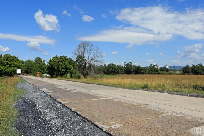
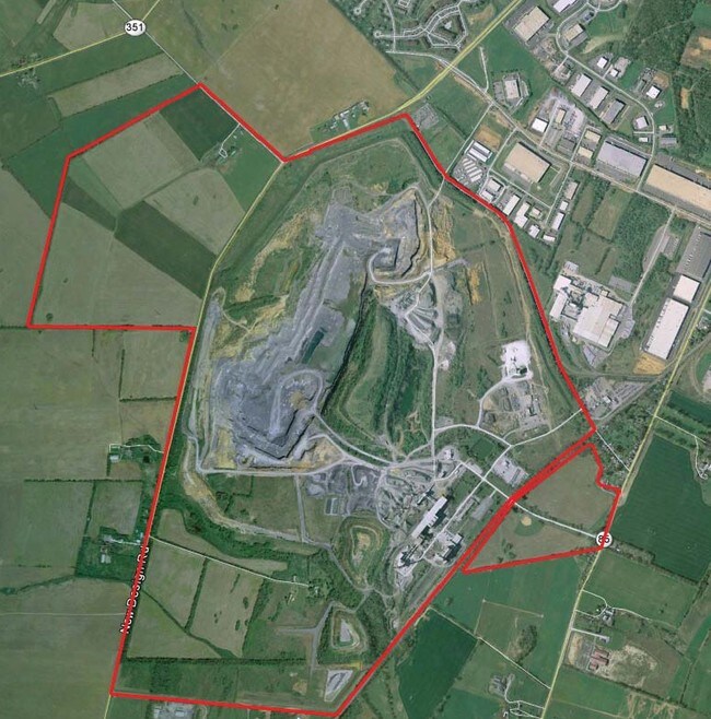
4120B Buckeystown Pike, Adamstown, MD 21710

NEARBY LISTINGS FOR SALE OR LEASE
-
-
-
-
-
-
No Photo
-
View all Adamstown listings for sale on LoopNet.com
Property Detail
4120B Buckeystown Pike
01-000136
Additional Plat Rogers Farm Llc 2059/686
Heavyindustrial
51.32 ACRES S/S NEW DESIGN RD W/LIME KILN RD
AE
Frederick
24021C0431E
Maryland
2024
132.20 AC
2025
Frederick
752302
Washington, DC
84,185 SF
Washington-Arlington-Alexandria, DC-VA-MD-WV
DEMOGRAPHICS near 4120B Buckeystown Pike
1 Mile
3 Mile
5 Mile
2024 Total Population
283
22,228
75,166
2029 Population
322
25,350
85,484
Pop Growth 2024-2029
+ 13.78%
+ 14.05%
+ 13.73%
Average Age
41
38
38
2024 Total Households
105
8,185
27,581
HH Growth 2024-2029
+ 14.29%
+ 14.49%
+ 14.22%
Median Household Inc
$103,125
$104,758
$99,625
Avg Household Size
2.50
2.60
2.60
2024 Avg HH Vehicles
2.00
2.00
2.00
Median Home Value
$444,642
$363,356
$374,784
Median Year Built
1990
1996
1994
Nearby Places
Map Layers
Map Styles
 Street
 Aerial
- Restaurants
- Banks
- Shops
- Fitness
- Groceries
PUBLIC TRANSPORTATION
COMMUTER RAIL
Monocacy Marc Eb (BRUNSWICK - WASHINGTON - Maryland Transit Administration)
DRIVE
WALK
Distance
Monocacy Marc Eb (BRUNSWICK - WASHINGTON - Maryland Transit Administration)
14 min
4.8 mi
Monocacy Marc Eb (BRUNSWICK - WASHINGTON - Maryland Transit Administration)
DRIVE
WALK
Distance
Monocacy Marc Eb (BRUNSWICK - WASHINGTON - Maryland Transit Administration)
14 min
4.8 mi
AIRPORT
Hagerstown Regional/Richard A Henson Field
DRIVE
WALK
Distance
Hagerstown Regional/Richard A Henson Field
52 min
34.6 mi
Washington Dulles International
DRIVE
WALK
Distance
Washington Dulles International
73 min
41.9 mi
Freight Ports
Port of Baltimore
DRIVE
WALK
Distance
Port of Baltimore
73 min
53.4 mi
Nearby Properties
Address
Land Use
TOTAL SIZE
Lot Size
Zoning
Address
Land Use
TOTAL SIZE
Lot Size
Zoning
747,653 SF
57.55 AC
LI
Address
Land Use
TOTAL SIZE
Lot Size
Zoning
3,478 SF
571.39 AC
GI
Address
Land Use
TOTAL SIZE
Lot Size
Zoning
668,533 SF
45.39 AC
MXD
Address
Land Use
TOTAL SIZE
Lot Size
Zoning
719,578 SF
48.06 AC
GC
Address
Land Use
TOTAL SIZE
Lot Size
Zoning
459,536 SF
65.48 AC
LI
Address
Land Use
TOTAL SIZE
Lot Size
Zoning
252,725 SF
46.49 AC
IE
Address
Land Use
TOTAL SIZE
Lot Size
Zoning
243,719 SF
37.59 AC
IE
Address
Land Use
TOTAL SIZE
Lot Size
Zoning
108.96 AC
I
Address
Land Use
TOTAL SIZE
Lot Size
Zoning
281,360 SF
21.16 AC
MXD
Address
Land Use
TOTAL SIZE
Lot Size
Zoning
134,300 SF
12.62 AC
PUD
Address
Land Use
TOTAL SIZE
Lot Size
Zoning
327,022 SF
15.61 AC
PUD
Address
Land Use
TOTAL SIZE
Lot Size
Zoning
82,480 SF
17.84 AC
LI
Address
Land Use
TOTAL SIZE
Lot Size
Zoning
185,639 SF
22.94 AC
ORI
Address
Land Use
TOTAL SIZE
Lot Size
Zoning
378,000 SF
20.28 AC
LI
Address
Land Use
TOTAL SIZE
Lot Size
Zoning
152,684 SF
30.10 AC
A
Address
Land Use
TOTAL SIZE
Lot Size
Zoning
169,802 SF
11.76 AC
PUD
Address
Land Use
TOTAL SIZE
Lot Size
Zoning
38,428 SF
74.89 AC
GI
Address
Land Use
TOTAL SIZE
Lot Size
Zoning
103,258 SF
10.46 AC
MXD
Address
Land Use
TOTAL SIZE
Lot Size
Zoning
170,940 SF
10.02 AC
LI
Address
Land Use
TOTAL SIZE
Lot Size
Zoning
213,234 SF
16.89 AC
ORI
Address
Land Use
TOTAL SIZE
Lot Size
Zoning
65,000 SF
5.16 AC
ORI
Address
Land Use
TOTAL SIZE
Lot Size
Zoning
67,961 SF
5.34 AC
LI
Address
Land Use
TOTAL SIZE
Lot Size
Zoning
348,955 SF
13.84 AC
PUD
Address
Land Use
TOTAL SIZE
Lot Size
Zoning
83,910 SF
13.40 AC
PUD
Address
Land Use
TOTAL SIZE
Lot Size
Zoning
149,806 SF
14.16 AC
MXD
Address
Land Use
TOTAL SIZE
Lot Size
Zoning
2,925 SF
423.90 AC
GI
Address
Land Use
TOTAL SIZE
Lot Size
Zoning
75,400 SF
4.53 AC
GC
Address
Land Use
TOTAL SIZE
Lot Size
Zoning
169,592 SF
10.21 AC
LI
Address
Land Use
TOTAL SIZE
Lot Size
Zoning
113,647 SF
15.33 AC
GC
Address
Land Use
TOTAL SIZE
Lot Size
Zoning
196,854 SF
17.88 AC
ORI
The World's #1 Commercial Real Estate Marketplace
Connect with us
© 2026 CoStar Group
The information above has been obtained from sources believed reliable. While we do not doubt its accuracy we have not verified it and make no guarantee, warranty or representation about it. It is your responsibility to independently confirm its accuracy and completeness. Any projections, opinions, assumptions, or estimates used are for example only and do not represent the current or future performance of the property. The value of this transaction to you depends on tax and other factors which should be evaluated by your tax, financial, and legal advisors. You and your advisors should conduct a careful, independent investigation of the property to determine to your satisfaction the suitability of the property for your needs.