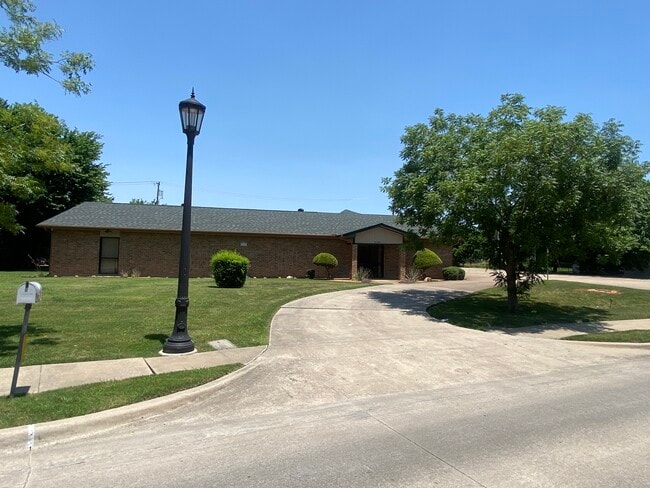
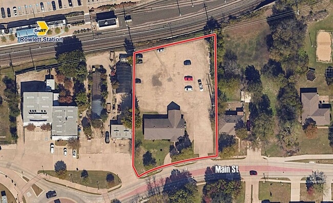
Property Record
4121 Main St, Rowlett, TX 75088

Property Detail
4121 Main St
65116536040090000
THOMAS PAYNE ABST 1165 PG 360 TR 9 ACS 0.822 LOC OT ROWLETT SH 3 INT200600013080 DD01032006 CO-DC 1165360400900 2CW11653604
Officebuilding
DALLAS
Z205
Texas
B and X Area of moderate flood hazard, usually the area between the limits of the 100-year and 500-year floods.
0.82 AC
2025
Garland
2025
Dallas/Ft Worth
018133
Dallas-Fort Worth-Arlington, TX
3,635 SF
NEARBY LISTINGS FOR SALE OR LEASE
DEMOGRAPHICS near 4121 Main St
1 mile
3 mile
5 mile
2025 Total Population
7,410
69,619
207,090
2030 Population
7,704
72,560
215,476
Pop Growth 2025-2030
+ 3.97%
+ 4.22%
+ 4.05%
Average Age
40
40
38
2025 Total Households
2,691
23,422
68,945
HH Growth 2025-2030
+ 4.09%
+ 4.30%
+ 4.23%
Median Household Inc
$100,158
$103,328
$87,232
Avg Household Size
2.70
2.90
2.90
2025 Avg HH Vehicles
2.00
2.00
2.00
Median Home Value
$356,166
$357,110
$319,401
Median Year Built
1987
1993
1987
Nearby Places
Map Layers
Map Styles
 Street
 Aerial
Layers
 Traffic
 Biking
Places
Listings with unknown addresses are not visible on the map
- Restaurants
- Banks
- Shops
- Fitness
- Groceries
PUBLIC TRANSPORTATION
TRANSIT/SUBWAY
Downtown Rowlett (Blue Line - Dallas Area Rapid Transit (DART))
Drive
Walk
Distance
Downtown Rowlett (Blue Line - Dallas Area Rapid Transit (DART))
2 min
5 min
0.3 mi
AIRPORT
Dallas Love Field
Drive
Walk
Distance
Dallas Love Field
38 min
24.0 mi
Dallas-Fort Worth International
Drive
Walk
Distance
Dallas-Fort Worth International
48 min
36.0 mi
SALE & LEASE HISTORY
LISTING DATE
SALE/LEASE

Jun 11, 2025
For Sale
Nearby Properties
Address
Land Use
TOTAL SIZE
Lot Size
Zoning
Address
Land Use
TOTAL SIZE
Lot Size
Zoning
559,567 SF
10.85 AC
Z80
Address
Land Use
TOTAL SIZE
Lot Size
Zoning
261,164 SF
32.58 AC
Address
Land Use
TOTAL SIZE
Lot Size
Zoning
283,096 SF
10.18 AC
Z80
Address
Land Use
TOTAL SIZE
Lot Size
Zoning
260,782 SF
16.30 AC
Z77
Address
Land Use
TOTAL SIZE
Lot Size
Zoning
427,231 SF
9.96 AC
Z38
Address
Land Use
TOTAL SIZE
Lot Size
Zoning
313,217 SF
3.61 AC
Z205
Address
Land Use
TOTAL SIZE
Lot Size
Zoning
228,458 SF
5.56 AC
Z236
Address
Land Use
TOTAL SIZE
Lot Size
Zoning
178,125 SF
10.50 AC
Z77
Address
Land Use
TOTAL SIZE
Lot Size
Zoning
138,183 SF
4.76 AC
Z80
Address
Land Use
TOTAL SIZE
Lot Size
Zoning
0.12 AC
Z63
Address
Land Use
TOTAL SIZE
Lot Size
Zoning
43,600 SF
62.86 AC
Z306
Address
Land Use
TOTAL SIZE
Lot Size
Zoning
420,500 SF
33.25 AC
Address
Land Use
TOTAL SIZE
Lot Size
Zoning
261,000 SF
1 AC
Z318
Address
Land Use
TOTAL SIZE
Lot Size
Zoning
271,051 SF
10.28 AC
Z01
Address
Land Use
TOTAL SIZE
Lot Size
Zoning
145,203 SF
12.86 AC
Z239
Address
Land Use
TOTAL SIZE
Lot Size
Zoning
76,812 SF
9.22 AC
Z144
Address
Land Use
TOTAL SIZE
Lot Size
Zoning
92,413 SF
4.98 AC
Z85
Address
Land Use
TOTAL SIZE
Lot Size
Zoning
226,800 SF
4.98 AC
Z340
Address
Land Use
TOTAL SIZE
Lot Size
Zoning
151,893 SF
5.40 AC
Z308
Address
Land Use
TOTAL SIZE
Lot Size
Zoning
82,847 SF
4.87 AC
Z236
Address
Land Use
TOTAL SIZE
Lot Size
Zoning
78,017 SF
1.75 AC
Z236
Address
Land Use
TOTAL SIZE
Lot Size
Zoning
140,000 SF
12.76 AC
Address
Land Use
TOTAL SIZE
Lot Size
Zoning
141,200 SF
10.81 AC
Address
Land Use
TOTAL SIZE
Lot Size
Zoning
150,926 SF
9.33 AC
Address
Land Use
TOTAL SIZE
Lot Size
Zoning
52,797 SF
5.41 AC
Z92
Address
Land Use
TOTAL SIZE
Lot Size
Zoning
147.23 AC
Z114
Address
Land Use
TOTAL SIZE
Lot Size
Zoning
0.02 AC
Z236
Address
Land Use
TOTAL SIZE
Lot Size
Zoning
203,983 SF
31.19 AC
Z92
Address
Land Use
TOTAL SIZE
Lot Size
Zoning
65,518 SF
1.34 AC
Z01
Address
Land Use
TOTAL SIZE
Lot Size
Zoning
178,197 SF
4.42 AC
Z239
The World's #1 Commercial Real Estate Marketplace
Connect with us
© 2026 CoStar Group
The information above has been obtained from sources believed reliable. While we do not doubt its accuracy we have not verified it and make no guarantee, warranty or representation about it. It is your responsibility to independently confirm its accuracy and completeness. Any projections, opinions, assumptions, or estimates used are for example only and do not represent the current or future performance of the property. The value of this transaction to you depends on tax and other factors which should be evaluated by your tax, financial, and legal advisors. You and your advisors should conduct a careful, independent investigation of the property to determine to your satisfaction the suitability of the property for your needs.