Property Record
1836 E 41St St, Los Angeles, CA 90058
Current Lease Availabilities
NEARBY LISTINGS FOR SALE OR LEASE
Property Detail
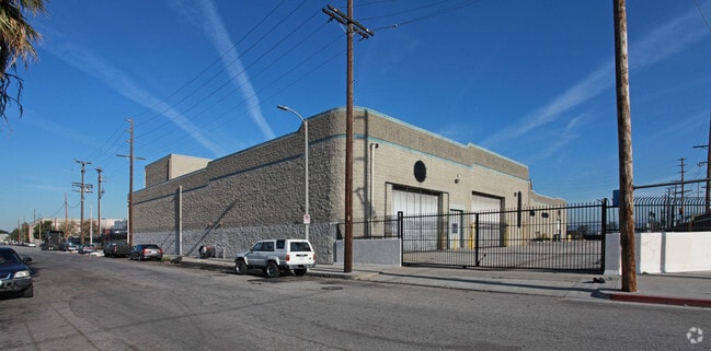
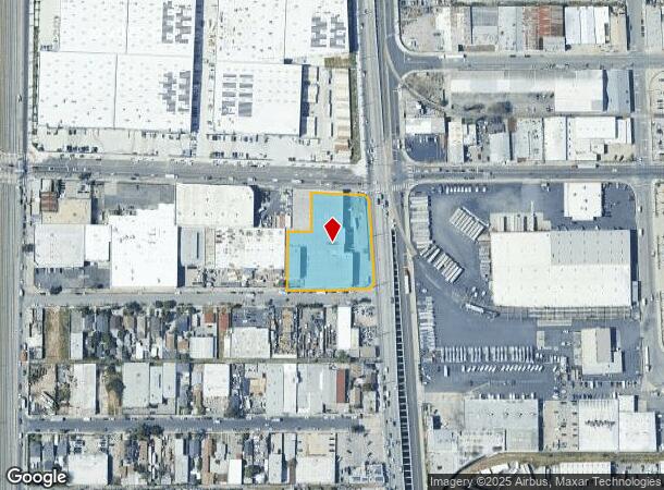
1836 E 41St St
Los Angeles-Long Beach-Glendale, CA
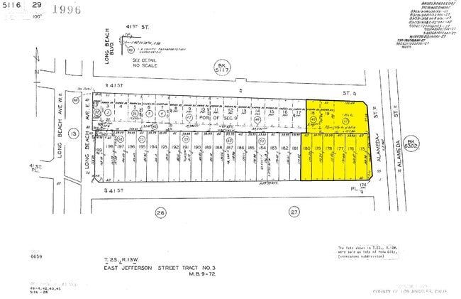
East Jefferson Street Tract #3
5116-029-057
FOR DESC SEE ASSESSORS MAPS
Warehouse
Los Angeles
X
California
06037C1638G
174
2024
1.45 AC
2025
Central Los Angeles
980016
Los Angeles
54,745 SF
DEMOGRAPHICS near 1836 E 41St St
1 Mile
3 Mile
5 Mile
2024 Total Population
25,805
354,573
1,177,175
2029 Population
23,974
338,668
1,130,573
Pop Growth 2024-2029
(7.10%)
(4.49%)
(3.96%)
Average Age
34
36
36
2024 Total Households
5,809
104,675
355,033
HH Growth 2024-2029
(7.85%)
(4.12%)
(3.81%)
Median Household Inc
$47,142
$48,500
$49,490
Avg Household Size
4.00
3.10
3.10
2024 Avg HH Vehicles
2.00
1.00
2.00
Median Home Value
$539,795
$613,082
$624,542
Median Year Built
1953
1956
1955
Nearby Places
Map Layers
Map Styles
 Street
 Aerial
- Restaurants
- Banks
- Shops
- Fitness
- Groceries
PUBLIC TRANSPORTATION
TRANSIT/SUBWAY
Vernon Station (Blue Line - Los Angeles County Metropolitan Transportation Authority (Metro))
DRIVE
WALK
Distance
Vernon Station (Blue Line - Los Angeles County Metropolitan Transportation Authority (Metro))
1 min
10 min
0.5 mi
COMMUTER RAIL
DRIVE
WALK
Distance
8 min
3.4 mi
Union Station (91 Line - Southern California Regional Rail Authority (Metrolink), Antelope Valley Line - Southern California Regional Rail Authority (Metrolink), Orange County Line - Southern California Regional Rail Authority (Metrolink), Riverside Line - Southern California Regional Rail Authority (Metrolink), San Bernardino Line - Southern California Regional Rail Authority (Metrolink), Ventura County Line - Southern California Regional Rail Authority (Metrolink))
DRIVE
WALK
Distance
Union Station (91 Line - Southern California Regional Rail Authority (Metrolink), Antelope Valley Line - Southern California Regional Rail Authority (Metrolink), Orange County Line - Southern California Regional Rail Authority (Metrolink), Riverside Line - Southern California Regional Rail Authority (Metrolink), San Bernardino Line - Southern California Regional Rail Authority (Metrolink), Ventura County Line - Southern California Regional Rail Authority (Metrolink))
11 min
3.8 mi
AIRPORT
Los Angeles International
DRIVE
WALK
Distance
Los Angeles International
24 min
13.4 mi
Long Beach (Daugherty Field)
DRIVE
WALK
Distance
Long Beach (Daugherty Field)
29 min
16.1 mi
Bob Hope
DRIVE
WALK
Distance
Bob Hope
28 min
20.4 mi
Freight Ports
Port of Long Beach
DRIVE
WALK
Distance
Port of Long Beach
30 min
18.5 mi
Nearby Properties
Address
Land Use
TOTAL SIZE
Lot Size
Zoning
Address
Land Use
TOTAL SIZE
Lot Size
Zoning
969,516 SF
14.75 AC
Address
Land Use
TOTAL SIZE
Lot Size
Zoning
717,065 SF
0.99 AC
LAC2
Address
Land Use
TOTAL SIZE
Lot Size
Zoning
200,811 SF
4.59 AC
LALASED
Address
Land Use
TOTAL SIZE
Lot Size
Zoning
1,178,786 SF
3.89 AC
LAC2
Address
Land Use
TOTAL SIZE
Lot Size
Zoning
764,804 SF
1.48 AC
Address
Land Use
TOTAL SIZE
Lot Size
Zoning
634,863 SF
2.97 AC
LAC2-4D
Address
Land Use
TOTAL SIZE
Lot Size
Zoning
420,864 SF
63.07 AC
LAUSC-1A
Address
Land Use
TOTAL SIZE
Lot Size
Zoning
574,047 SF
1.70 AC
LAR5
Address
Land Use
TOTAL SIZE
Lot Size
Zoning
773,409 SF
1.39 AC
LAC4
Address
Land Use
TOTAL SIZE
Lot Size
Zoning
2,697,158 SF
20.18 AC
LAM2
Address
Land Use
TOTAL SIZE
Lot Size
Zoning
256,059 SF
Address
Land Use
TOTAL SIZE
Lot Size
Zoning
581,956 SF
0.89 AC
LAR5
Address
Land Use
TOTAL SIZE
Lot Size
Zoning
387,421 SF
1.08 AC
LAR5
Address
Land Use
TOTAL SIZE
Lot Size
Zoning
195,675 SF
LAC2
Address
Land Use
TOTAL SIZE
Lot Size
Zoning
377,377 SF
0.65 AC
LAC2
Address
Land Use
TOTAL SIZE
Lot Size
Zoning
200,689 SF
5.79 AC
LAUSC-1A
Address
Land Use
TOTAL SIZE
Lot Size
Zoning
364,997 SF
1.24 AC
LAR5
Address
Land Use
TOTAL SIZE
Lot Size
Zoning
50,048 SF
1.16 AC
LAR5
Address
Land Use
TOTAL SIZE
Lot Size
Zoning
337,025 SF
14.59 AC
LAUSC-1A
Address
Land Use
TOTAL SIZE
Lot Size
Zoning
666,499 SF
10.63 AC
LAC2
Address
Land Use
TOTAL SIZE
Lot Size
Zoning
298,630 SF
4.64 AC
LAUSC-1B
Address
Land Use
TOTAL SIZE
Lot Size
Zoning
461,090 SF
0.47 AC
LAC2
Address
Land Use
TOTAL SIZE
Lot Size
Zoning
329,487 SF
0.94 AC
LAC2
Address
Land Use
TOTAL SIZE
Lot Size
Zoning
466,058 SF
2.54 AC
Address
Land Use
TOTAL SIZE
Lot Size
Zoning
320,925 SF
0.88 AC
LAC2
Address
Land Use
TOTAL SIZE
Lot Size
Zoning
444,139 SF
3.63 AC
LAM3
Address
Land Use
TOTAL SIZE
Lot Size
Zoning
9.17 AC
LALASED
Address
Land Use
TOTAL SIZE
Lot Size
Zoning
448,914 SF
2.67 AC
LAC2
Address
Land Use
TOTAL SIZE
Lot Size
Zoning
311,717 SF
1.45 AC
LAR5
Address
Land Use
TOTAL SIZE
Lot Size
Zoning
274,675 SF
1.34 AC
LAR5
The World's #1 Commercial Real Estate Marketplace
Connect with us
© 2026 CoStar Group
The information above has been obtained from sources believed reliable. While we do not doubt its accuracy we have not verified it and make no guarantee, warranty or representation about it. It is your responsibility to independently confirm its accuracy and completeness. Any projections, opinions, assumptions, or estimates used are for example only and do not represent the current or future performance of the property. The value of this transaction to you depends on tax and other factors which should be evaluated by your tax, financial, and legal advisors. You and your advisors should conduct a careful, independent investigation of the property to determine to your satisfaction the suitability of the property for your needs.