Property Record
4123 142Nd Ave E, Sumner, WA 98390
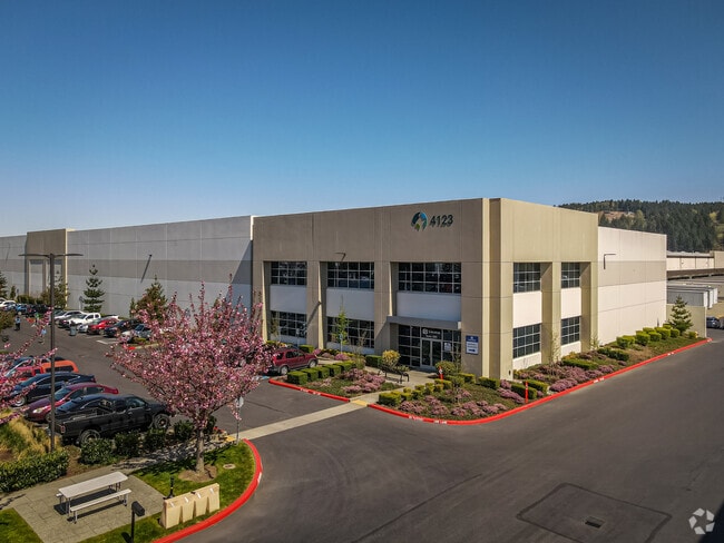

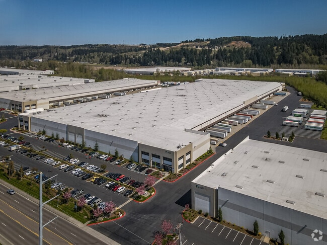
Property Detail
4123 142Nd Ave E
042013-4711
SECTION 13 TOWNSHIP 20 RANGE 04 QUARTER 42 PARCEL A OF BLA 2015-07-27-5002 DESC AS BEG AT NW COR OF PARCEL C OF BLA 2013-07-11-5001 DESC AS COM AT INTER OF N LI OF A MORRISON DLC & N & S C/L OF SEC TH N 89 DEG 01 MIN 16 SEC E 146 FT TH CONT N 89 DEG
Warehouse
Pierce
M1
Washington
AE The base floodplain where base flood elevations are provided. AE Zones are now used on new format FIRMs instead of A1-A30 Zones.
27.43 AC
2024
Puyallup/S Hill
2025
Seattle/Puget Sound
073301
Seattle-Tacoma-Bellevue, WA
648,679 SF
NEARBY LISTINGS FOR SALE OR LEASE
DEMOGRAPHICS near 4123 142Nd Ave E
1 mile
3 mile
5 mile
2025 Total Population
2,467
50,248
162,805
2030 Population
2,482
51,047
166,136
Pop Growth 2025-2030
+ 0.61%
+ 1.59%
+ 2.05%
Average Age
38
39
39
2025 Total Households
991
19,400
59,781
HH Growth 2025-2030
+ 0.50%
+ 1.61%
+ 2.04%
Median Household Inc
$92,576
$110,801
$108,276
Avg Household Size
2.50
2.60
2.70
2025 Avg HH Vehicles
2.00
2.00
2.00
Median Home Value
$558,654
$652,831
$618,289
Median Year Built
1980
1994
1989
Nearby Places
Map Layers
Map Styles
 Street
 Aerial
Layers
 Traffic
 Biking
Places
Listings with unknown addresses are not visible on the map
- Restaurants
- Banks
- Shops
- Fitness
- Groceries
PUBLIC TRANSPORTATION
AIRPORT
Seattle-Tacoma International
Drive
Walk
Distance
Seattle-Tacoma International
35 min
20.0 mi
Freight Ports
Port of Tacoma
Drive
Walk
Distance
Port of Tacoma
22 min
11.9 mi
SALE & LEASE HISTORY
LISTING DATE
SALE/LEASE

May 30, 2018
For Lease
Jul 24, 2019
For Lease
Jul 10, 2020
For Lease
Jan 11, 2017
For Lease
Feb 14, 2019
For Lease
Nearby Properties
Address
Land Use
TOTAL SIZE
Lot Size
Zoning
Address
Land Use
TOTAL SIZE
Lot Size
Zoning
833,773 SF
94.01 AC
M1
Address
Land Use
TOTAL SIZE
Lot Size
Zoning
957,681 SF
56.53 AC
ML
Address
Land Use
TOTAL SIZE
Lot Size
Zoning
438,065 SF
20.43 AC
PUY
Address
Land Use
TOTAL SIZE
Lot Size
Zoning
425,832 SF
11 AC
RM-20
Address
Land Use
TOTAL SIZE
Lot Size
Zoning
Address
Land Use
TOTAL SIZE
Lot Size
Zoning
501,104 SF
21.73 AC
Address
Land Use
TOTAL SIZE
Lot Size
Zoning
506,925 SF
24.22 AC
M1
Address
Land Use
TOTAL SIZE
Lot Size
Zoning
521,674 SF
24.55 AC
M1
Address
Land Use
TOTAL SIZE
Lot Size
Zoning
255,871 SF
11.17 AC
EDGWD
Address
Land Use
TOTAL SIZE
Lot Size
Zoning
208,900 SF
8.72 AC
EDGWD
Address
Land Use
TOTAL SIZE
Lot Size
Zoning
492,124 SF
21.54 AC
M1
Address
Land Use
TOTAL SIZE
Lot Size
Zoning
441,316 SF
20.26 AC
Address
Land Use
TOTAL SIZE
Lot Size
Zoning
251,498 SF
13.79 AC
LAKELAND H
Address
Land Use
TOTAL SIZE
Lot Size
Zoning
476,362 SF
26.61 AC
Address
Land Use
TOTAL SIZE
Lot Size
Zoning
503,526 SF
16.52 AC
M1
Address
Land Use
TOTAL SIZE
Lot Size
Zoning
215,619 SF
21.57 AC
TV
Address
Land Use
TOTAL SIZE
Lot Size
Zoning
430,880 SF
23.46 AC
M1
Address
Land Use
TOTAL SIZE
Lot Size
Zoning
428,056 SF
17.45 AC
M1
Address
Land Use
TOTAL SIZE
Lot Size
Zoning
204,727 SF
18.63 AC
TV
Address
Land Use
TOTAL SIZE
Lot Size
Zoning
218,293 SF
12.20 AC
RM-20
Address
Land Use
TOTAL SIZE
Lot Size
Zoning
223,969 SF
16.97 AC
RM-20
Address
Land Use
TOTAL SIZE
Lot Size
Zoning
401,076 SF
16.77 AC
M1
Address
Land Use
TOTAL SIZE
Lot Size
Zoning
385,468 SF
18.22 AC
M1
Address
Land Use
TOTAL SIZE
Lot Size
Zoning
427,253 SF
18.46 AC
M1
Address
Land Use
TOTAL SIZE
Lot Size
Zoning
382,800 SF
19.15 AC
M1
Address
Land Use
TOTAL SIZE
Lot Size
Zoning
370,087 SF
15.61 AC
M1
Address
Land Use
TOTAL SIZE
Lot Size
Zoning
350,075 SF
16.66 AC
M1
Address
Land Use
TOTAL SIZE
Lot Size
Zoning
333,180 SF
18.13 AC
Address
Land Use
TOTAL SIZE
Lot Size
Zoning
127,096 SF
12.48 AC
LAKELAND H
The World's #1 Commercial Real Estate Marketplace
Connect with us
© 2026 CoStar Group
The information above has been obtained from sources believed reliable. While we do not doubt its accuracy we have not verified it and make no guarantee, warranty or representation about it. It is your responsibility to independently confirm its accuracy and completeness. Any projections, opinions, assumptions, or estimates used are for example only and do not represent the current or future performance of the property. The value of this transaction to you depends on tax and other factors which should be evaluated by your tax, financial, and legal advisors. You and your advisors should conduct a careful, independent investigation of the property to determine to your satisfaction the suitability of the property for your needs.