Property Record
4124 S Mooney Blvd, Visalia, CA 93277


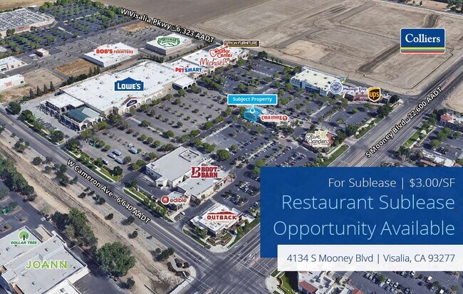

Property Detail
4124 S Mooney Blvd
122-420-006-000
PARCEL 9 PARCEL MAP 4547PM 46-52
Regionalshoppingcenterormallwithanchorstore
TULARE
CR
California
C and X Area of minimal flood hazard, usually depicted on FIRMs as above the 500-year flood level.
1.25 AC
2024
Southwest Visalia
2025
Visalia/Porterville
002011
Visalia, CA
9,400 SF
NEARBY LISTINGS FOR SALE OR LEASE
DEMOGRAPHICS near 4124 S Mooney Blvd
1 mile
3 mile
5 mile
2025 Total Population
8,995
72,201
162,888
2030 Population
9,191
73,835
166,738
Pop Growth 2025-2030
+ 2.18%
+ 2.26%
+ 2.36%
Average Age
39
38
37
2025 Total Households
3,190
25,571
53,628
HH Growth 2025-2030
+ 2.16%
+ 2.26%
+ 2.33%
Median Household Inc
$76,198
$82,055
$87,356
Avg Household Size
2.70
2.70
3.00
2025 Avg HH Vehicles
2.00
2.00
2.00
Median Home Value
$321,709
$354,510
$377,030
Median Year Built
1984
1979
1988
Nearby Places
Map Layers
Map Styles
 Street
 Aerial
Layers
 Traffic
 Biking
Places
Listings with unknown addresses are not visible on the map
- Restaurants
- Banks
- Shops
- Fitness
- Groceries
SALE & LEASE HISTORY
LISTING DATE
SALE/LEASE

Jan 19, 2024
For Lease
Aug 25, 2021
For Sale
Apr 25, 2023
For Lease
Apr 18, 2023
For Lease
Nearby Properties
Address
Land Use
TOTAL SIZE
Lot Size
Zoning
Address
Land Use
TOTAL SIZE
Lot Size
Zoning
393,784 SF
17.79 AC
CR
Address
Land Use
TOTAL SIZE
Lot Size
Zoning
47,768 SF
6.76 AC
RM2
Address
Land Use
TOTAL SIZE
Lot Size
Zoning
42,084 SF
9.18 AC
RM2
Address
Land Use
TOTAL SIZE
Lot Size
Zoning
159,023 SF
14.82 AC
CR
Address
Land Use
TOTAL SIZE
Lot Size
Zoning
24.81 AC
Address
Land Use
TOTAL SIZE
Lot Size
Zoning
121,380 SF
24.96 AC
QP
Address
Land Use
TOTAL SIZE
Lot Size
Zoning
91,492 SF
4.80 AC
RM3
Address
Land Use
TOTAL SIZE
Lot Size
Zoning
148,667 SF
11.35 AC
CR
Address
Land Use
TOTAL SIZE
Lot Size
Zoning
6.96 AC
Address
Land Use
TOTAL SIZE
Lot Size
Zoning
61,587 SF
0.43 AC
PA
Address
Land Use
TOTAL SIZE
Lot Size
Zoning
178,626 SF
11.39 AC
PA
Address
Land Use
TOTAL SIZE
Lot Size
Zoning
4.24 AC
Address
Land Use
TOTAL SIZE
Lot Size
Zoning
134,561 SF
11.55 AC
CR
Address
Land Use
TOTAL SIZE
Lot Size
Zoning
92,298 SF
7.32 AC
CR
Address
Land Use
TOTAL SIZE
Lot Size
Zoning
33,981 SF
18.12 AC
Address
Land Use
TOTAL SIZE
Lot Size
Zoning
126,532 SF
8.63 AC
RM2
Address
Land Use
TOTAL SIZE
Lot Size
Zoning
47,242 SF
3.94 AC
QP-PA
Address
Land Use
TOTAL SIZE
Lot Size
Zoning
103,000 SF
11.17 AC
CCM
Address
Land Use
TOTAL SIZE
Lot Size
Zoning
78,751 SF
2.67 AC
R-M-2
Address
Land Use
TOTAL SIZE
Lot Size
Zoning
134,055 SF
3.49 AC
CDT
Address
Land Use
TOTAL SIZE
Lot Size
Zoning
82,200 SF
6.29 AC
CSO
Address
Land Use
TOTAL SIZE
Lot Size
Zoning
69,120 SF
5.23 AC
CR
Address
Land Use
TOTAL SIZE
Lot Size
Zoning
28,557 SF
2.88 AC
CR
Address
Land Use
TOTAL SIZE
Lot Size
Zoning
83,011 SF
4.46 AC
QP
Address
Land Use
TOTAL SIZE
Lot Size
Zoning
88,589 SF
7.98 AC
CR
Address
Land Use
TOTAL SIZE
Lot Size
Zoning
133,910 SF
14.35 AC
CSO
Address
Land Use
TOTAL SIZE
Lot Size
Zoning
36.46 AC
The World's #1 Commercial Real Estate Marketplace
Connect with us
© 2026 CoStar Group
The information above has been obtained from sources believed reliable. While we do not doubt its accuracy we have not verified it and make no guarantee, warranty or representation about it. It is your responsibility to independently confirm its accuracy and completeness. Any projections, opinions, assumptions, or estimates used are for example only and do not represent the current or future performance of the property. The value of this transaction to you depends on tax and other factors which should be evaluated by your tax, financial, and legal advisors. You and your advisors should conduct a careful, independent investigation of the property to determine to your satisfaction the suitability of the property for your needs.