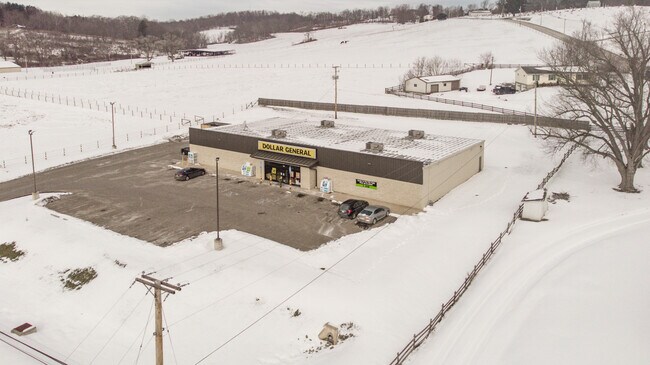
Property Record
4125 West Pike, Zanesville, OH 43701


NEARBY LISTINGS FOR SALE OR LEASE
-
-
View all Zanesville listings for sale on LoopNet.com
Property Detail
4125 West Pike
17-82-02-39-003
R 8 T 1 QT3 1.795A
Storebuilding
Muskingum
X
Ohio
39119C0280G
1.80 AC
2024
Ohio South Area
2024
Other Market Areas
911300
Zanesville, OH
9,283 SF
DEMOGRAPHICS near 4125 West Pike
1 Mile
3 Mile
5 Mile
2024 Total Population
769
8,990
43,974
2029 Population
764
8,979
44,166
Pop Growth 2024-2029
(0.65%)
(0.12%)
+ 0.44%
Average Age
41
41
41
2024 Total Households
317
3,681
18,735
HH Growth 2024-2029
(0.63%)
(0.19%)
+ 0.37%
Median Household Inc
$52,500
$53,000
$44,543
Avg Household Size
2.40
2.40
2.30
2024 Avg HH Vehicles
2.00
2.00
2.00
Median Home Value
$149,019
$148,459
$130,721
Median Year Built
1964
1967
1960
Nearby Places
Map Layers
Map Styles
 Street
 Aerial
- Restaurants
- Banks
- Shops
- Fitness
- Groceries
SALE & LEASE HISTORY
LISTING DATE
SALE/LEASE

Feb 04, 2022
For Sale
Dec 14, 2018
For Sale
Apr 01, 2019
For Sale
Nearby Properties
Address
Land Use
TOTAL SIZE
Lot Size
Zoning
Address
Land Use
TOTAL SIZE
Lot Size
Zoning
41,718 SF
165.54 AC
Address
Land Use
TOTAL SIZE
Lot Size
Zoning
149,148 SF
61.69 AC
RS2
Address
Land Use
TOTAL SIZE
Lot Size
Zoning
74,060 SF
47.47 AC
Address
Land Use
TOTAL SIZE
Lot Size
Zoning
2,485 SF
28.07 AC
Address
Land Use
TOTAL SIZE
Lot Size
Zoning
83,031 SF
7.30 AC
RS4
Address
Land Use
TOTAL SIZE
Lot Size
Zoning
42,255 SF
6.51 AC
Address
Land Use
TOTAL SIZE
Lot Size
Zoning
58,396 SF
9.83 AC
Address
Land Use
TOTAL SIZE
Lot Size
Zoning
64,732 SF
6.37 AC
RM1
Address
Land Use
TOTAL SIZE
Lot Size
Zoning
10,469 SF
8.63 AC
RM1
Address
Land Use
TOTAL SIZE
Lot Size
Zoning
28,906 SF
4.75 AC
COMM
Address
Land Use
TOTAL SIZE
Lot Size
Zoning
32,592 SF
8.22 AC
RES
Address
Land Use
TOTAL SIZE
Lot Size
Zoning
132,528 SF
2.27 AC
I1
Address
Land Use
TOTAL SIZE
Lot Size
Zoning
98.11 AC
Address
Land Use
TOTAL SIZE
Lot Size
Zoning
32,138 SF
5.36 AC
Address
Land Use
TOTAL SIZE
Lot Size
Zoning
31,261 SF
74.04 AC
AE
Address
Land Use
TOTAL SIZE
Lot Size
Zoning
12,279 SF
8.52 AC
RS-3
Address
Land Use
TOTAL SIZE
Lot Size
Zoning
35,476 SF
1.62 AC
RS4
Address
Land Use
TOTAL SIZE
Lot Size
Zoning
60,680 SF
22.79 AC
Address
Land Use
TOTAL SIZE
Lot Size
Zoning
20.06 AC
Address
Land Use
TOTAL SIZE
Lot Size
Zoning
40,915 SF
1.76 AC
RS4
Address
Land Use
TOTAL SIZE
Lot Size
Zoning
37,896 SF
3.04 AC
RES
Address
Land Use
TOTAL SIZE
Lot Size
Zoning
20,314 SF
4.65 AC
Address
Land Use
TOTAL SIZE
Lot Size
Zoning
6,256 SF
24.63 AC
COMM
Address
Land Use
TOTAL SIZE
Lot Size
Zoning
2,838 SF
1.94 AC
RM1
Address
Land Use
TOTAL SIZE
Lot Size
Zoning
11.22 AC
Address
Land Use
TOTAL SIZE
Lot Size
Zoning
2,464 SF
21.16 AC
C4
Address
Land Use
TOTAL SIZE
Lot Size
Zoning
3,456 SF
2.89 AC
RES
Address
Land Use
TOTAL SIZE
Lot Size
Zoning
7,321 SF
2 AC
Address
Land Use
TOTAL SIZE
Lot Size
Zoning
5.29 AC
Address
Land Use
TOTAL SIZE
Lot Size
Zoning
5.18 AC
The World's #1 Commercial Real Estate Marketplace
Connect with us
© 2026 CoStar Group
The information above has been obtained from sources believed reliable. While we do not doubt its accuracy we have not verified it and make no guarantee, warranty or representation about it. It is your responsibility to independently confirm its accuracy and completeness. Any projections, opinions, assumptions, or estimates used are for example only and do not represent the current or future performance of the property. The value of this transaction to you depends on tax and other factors which should be evaluated by your tax, financial, and legal advisors. You and your advisors should conduct a careful, independent investigation of the property to determine to your satisfaction the suitability of the property for your needs.