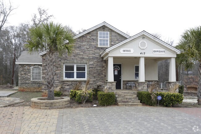
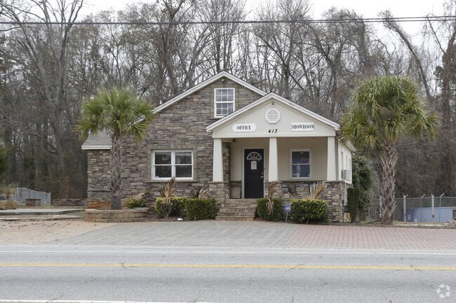
Property Record
501 Highway 29 Byp N, Anderson, SC 29621
Property Detail
501 Highway 29 Byp N
Greenville-Anderson-Greer, SC
CP 1521/5A F098 D322 PP 193/4B HWY 29 BYP N 1.63 AC
149-20-02-007
ANDERSON
Commercialnec
South Carolina
B and X Area of moderate flood hazard, usually the area between the limits of the 100-year and 500-year floods.
1.63 AC
2025
Anderson County
2025
Greenville/Spartanburg
000300
NEARBY LISTINGS FOR SALE OR LEASE
DEMOGRAPHICS near 501 Highway 29 Byp N
1 mile
3 mile
5 mile
2025 Total Population
3,394
31,709
66,986
2030 Population
3,569
33,633
70,826
Pop Growth 2025-2030
+ 5.16%
+ 6.07%
+ 5.73%
Average Age
36
39
40
2025 Total Households
1,294
12,206
26,428
HH Growth 2025-2030
+ 5.33%
+ 6.17%
+ 5.85%
Median Household Inc
$38,853
$51,241
$52,238
Avg Household Size
2.60
2.30
2.40
2025 Avg HH Vehicles
2.00
2.00
2.00
Median Home Value
$183,794
$195,637
$202,657
Median Year Built
1974
1977
1979
Nearby Places
Map Layers
Map Styles
 Street
 Aerial
Layers
 Traffic
 Biking
Places
Listings with unknown addresses are not visible on the map
- Restaurants
- Banks
- Shops
- Fitness
- Groceries
SALE & LEASE HISTORY
LISTING DATE
SALE/LEASE

Sep 18, 2017
For Sale
Jul 05, 2018
For Lease
Nearby Properties
Address
Land Use
TOTAL SIZE
Lot Size
Zoning
Address
Land Use
TOTAL SIZE
Lot Size
Zoning
17,286 SF
19.71 AC
Address
Land Use
TOTAL SIZE
Lot Size
Zoning
13,220 SF
13.49 AC
Address
Land Use
TOTAL SIZE
Lot Size
Zoning
15,168 SF
11.99 AC
Address
Land Use
TOTAL SIZE
Lot Size
Zoning
7,568 SF
10.99 AC
Address
Land Use
TOTAL SIZE
Lot Size
Zoning
25,908 SF
12.50 AC
Address
Land Use
TOTAL SIZE
Lot Size
Zoning
91,698 SF
10.04 AC
Address
Land Use
TOTAL SIZE
Lot Size
Zoning
40,071 SF
18.83 AC
Address
Land Use
TOTAL SIZE
Lot Size
Zoning
61,281 SF
0.74 AC
Address
Land Use
TOTAL SIZE
Lot Size
Zoning
0.74 AC
Address
Land Use
TOTAL SIZE
Lot Size
Zoning
110,140 SF
6 AC
Address
Land Use
TOTAL SIZE
Lot Size
Zoning
80,205 SF
9.58 AC
Address
Land Use
TOTAL SIZE
Lot Size
Zoning
149,148 SF
16.87 AC
Address
Land Use
TOTAL SIZE
Lot Size
Zoning
70,821 SF
3.57 AC
Address
Land Use
TOTAL SIZE
Lot Size
Zoning
45,014 SF
0.29 AC
Address
Land Use
TOTAL SIZE
Lot Size
Zoning
46,410 SF
4.88 AC
Address
Land Use
TOTAL SIZE
Lot Size
Zoning
24.90 AC
Address
Land Use
TOTAL SIZE
Lot Size
Zoning
9,406 SF
7.92 AC
Address
Land Use
TOTAL SIZE
Lot Size
Zoning
44,568 SF
2.47 AC
Address
Land Use
TOTAL SIZE
Lot Size
Zoning
1,408 SF
20.24 AC
Address
Land Use
TOTAL SIZE
Lot Size
Zoning
31,970 SF
2.87 AC
Address
Land Use
TOTAL SIZE
Lot Size
Zoning
2,315 SF
Address
Land Use
TOTAL SIZE
Lot Size
Zoning
4,068 SF
3.58 AC
Address
Land Use
TOTAL SIZE
Lot Size
Zoning
44,358 SF
6.25 AC
Address
Land Use
TOTAL SIZE
Lot Size
Zoning
1.48 AC
Address
Land Use
TOTAL SIZE
Lot Size
Zoning
14,749 SF
1.58 AC
Address
Land Use
TOTAL SIZE
Lot Size
Zoning
30,796 SF
3.56 AC
Address
Land Use
TOTAL SIZE
Lot Size
Zoning
3,080 SF
1 AC
Address
Land Use
TOTAL SIZE
Lot Size
Zoning
24,661 SF
41.82 AC
The World's #1 Commercial Real Estate Marketplace
Connect with us
© 2026 CoStar Group
The information above has been obtained from sources believed reliable. While we do not doubt its accuracy we have not verified it and make no guarantee, warranty or representation about it. It is your responsibility to independently confirm its accuracy and completeness. Any projections, opinions, assumptions, or estimates used are for example only and do not represent the current or future performance of the property. The value of this transaction to you depends on tax and other factors which should be evaluated by your tax, financial, and legal advisors. You and your advisors should conduct a careful, independent investigation of the property to determine to your satisfaction the suitability of the property for your needs.