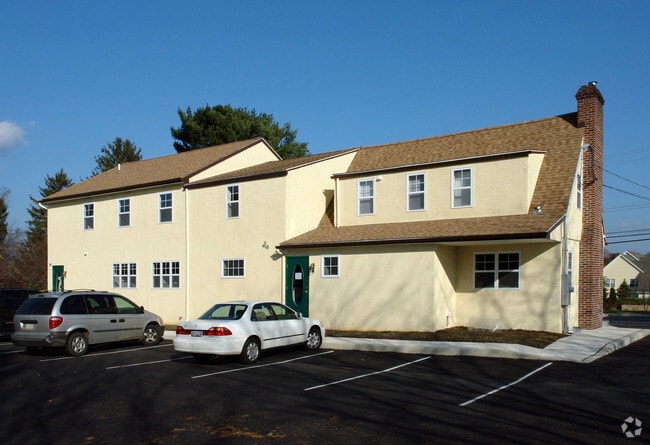
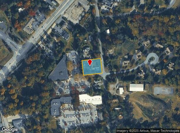
Property Record
413 Mcfarlan Rd, Kennett Square, PA 19348

NEARBY LISTINGS FOR SALE OR LEASE
Property Detail
413 Mcfarlan Rd
Philadelphia-Camden-Wilmington, PA-NJ-DE-MD
Dominico Vincenti
62-004-0063.0000
LOT & COMM BLDG
Officebuilding
Chester
X
Pennsylvania
42029C0295G
16
2024
0.69 AC
2025
Outer Chester County
303301
Philadelphia
4,682 SF
DEMOGRAPHICS near 413 Mcfarlan Rd
1 Mile
3 Mile
5 Mile
2024 Total Population
5,949
25,953
47,524
2029 Population
6,321
27,375
49,477
Pop Growth 2024-2029
+ 6.25%
+ 5.48%
+ 4.11%
Average Age
40
43
43
2024 Total Households
2,110
9,596
16,859
HH Growth 2024-2029
+ 6.45%
+ 5.66%
+ 4.42%
Median Household Inc
$100,558
$112,842
$127,037
Avg Household Size
2.70
2.60
2.70
2024 Avg HH Vehicles
2.00
2.00
2.00
Median Home Value
$446,035
$462,838
$486,011
Median Year Built
1982
1986
1985
Nearby Places
Map Layers
Map Styles
 Street
 Aerial
- Restaurants
- Banks
- Shops
- Fitness
- Groceries
PUBLIC TRANSPORTATION
AIRPORT
Philadelphia International
DRIVE
WALK
Distance
Philadelphia International
43 min
26.5 mi
Freight Ports
Port of Wilmington, RI
DRIVE
WALK
Distance
Port of Wilmington, RI
34 min
15.6 mi
Nearby Properties
Address
Land Use
TOTAL SIZE
Lot Size
Zoning
Address
Land Use
TOTAL SIZE
Lot Size
Zoning
260,160 SF
315.10 AC
RB
Address
Land Use
TOTAL SIZE
Lot Size
Zoning
387,796 SF
41.80 AC
ES1
Address
Land Use
TOTAL SIZE
Lot Size
Zoning
458,327 SF
122.55 AC
R4
Address
Land Use
TOTAL SIZE
Lot Size
Zoning
412,884 SF
100.50 AC
R5
Address
Land Use
TOTAL SIZE
Lot Size
Zoning
215,130 SF
11.80 AC
R2
Address
Land Use
TOTAL SIZE
Lot Size
Zoning
144,384 SF
25.30 AC
HC
Address
Land Use
TOTAL SIZE
Lot Size
Zoning
238,215 SF
35.70 AC
R3
Address
Land Use
TOTAL SIZE
Lot Size
Zoning
159,484 SF
22.01 AC
HC
Address
Land Use
TOTAL SIZE
Lot Size
Zoning
121,326 SF
14.98 AC
R2
Address
Land Use
TOTAL SIZE
Lot Size
Zoning
121,326 SF
14.98 AC
R2
Address
Land Use
TOTAL SIZE
Lot Size
Zoning
131,082 SF
35.70 AC
RB
Address
Land Use
TOTAL SIZE
Lot Size
Zoning
99,228 SF
0.57 AC
C2
Address
Land Use
TOTAL SIZE
Lot Size
Zoning
67,011 SF
6.78 AC
R2A
Address
Land Use
TOTAL SIZE
Lot Size
Zoning
114,126 SF
18.10 AC
CI
Address
Land Use
TOTAL SIZE
Lot Size
Zoning
67,244 SF
9.50 AC
MU
Address
Land Use
TOTAL SIZE
Lot Size
Zoning
59,836 SF
6.33 AC
R2
Address
Land Use
TOTAL SIZE
Lot Size
Zoning
74,992 SF
16.26 AC
R2
Address
Land Use
TOTAL SIZE
Lot Size
Zoning
200,337 SF
14 AC
CI
Address
Land Use
TOTAL SIZE
Lot Size
Zoning
64,946 SF
0.18 AC
C1
Address
Land Use
TOTAL SIZE
Lot Size
Zoning
65,227 SF
24.50 AC
R2
Address
Land Use
TOTAL SIZE
Lot Size
Zoning
53,134 SF
1.76 AC
R2
Address
Land Use
TOTAL SIZE
Lot Size
Zoning
60,936 SF
3.53 AC
R2
Address
Land Use
TOTAL SIZE
Lot Size
Zoning
65,310 SF
5.07 AC
RB
Address
Land Use
TOTAL SIZE
Lot Size
Zoning
35,784 SF
119.80 AC
R2
Address
Land Use
TOTAL SIZE
Lot Size
Zoning
17,781 SF
6.70 AC
MU
Address
Land Use
TOTAL SIZE
Lot Size
Zoning
175,250 SF
50 AC
SA
Address
Land Use
TOTAL SIZE
Lot Size
Zoning
54,097 SF
3.80 AC
R3
Address
Land Use
TOTAL SIZE
Lot Size
Zoning
46,364 SF
2.15 AC
RB
Address
Land Use
TOTAL SIZE
Lot Size
Zoning
85,568 SF
6.20 AC
C1
Address
Land Use
TOTAL SIZE
Lot Size
Zoning
70,448 SF
11.40 AC
CI
The World's #1 Commercial Real Estate Marketplace
Connect with us
© 2025 CoStar Group
The information above has been obtained from sources believed reliable. While we do not doubt its accuracy we have not verified it and make no guarantee, warranty or representation about it. It is your responsibility to independently confirm its accuracy and completeness. Any projections, opinions, assumptions, or estimates used are for example only and do not represent the current or future performance of the property. The value of this transaction to you depends on tax and other factors which should be evaluated by your tax, financial, and legal advisors. You and your advisors should conduct a careful, independent investigation of the property to determine to your satisfaction the suitability of the property for your needs.