Property Record
4131 Fescue Ct, Hope Mills, NC 28348

NEARBY LISTINGS FOR SALE OR LEASE
-
-
View all Hope Mills listings for sale on LoopNet.com
Property Detail
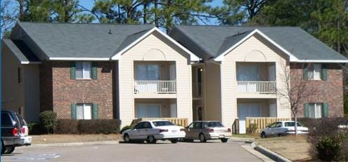
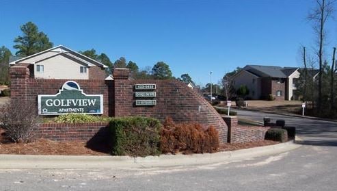
4131 Fescue Ct
Fayetteville, NC
Golfview Apartments
0404-81-8265
UNITED REALTY OF FAY & VFW LO:1 SE:01 PL:0092-0120
Apartment
Cumberland
AE
North Carolina
3720040400J
1
2025
6.08 AC
2025
South View
001605
Fayetteville
1,726 SF
DEMOGRAPHICS near 4131 Fescue Ct
1 Mile
3 Mile
5 Mile
2024 Total Population
6,627
34,553
92,097
2029 Population
6,498
34,309
91,752
Pop Growth 2024-2029
(1.95%)
(0.71%)
(0.37%)
Average Age
36
36
36
2024 Total Households
2,466
12,600
34,040
HH Growth 2024-2029
(1.95%)
(0.74%)
(0.38%)
Median Household Inc
$55,883
$59,260
$60,132
Avg Household Size
2.60
2.70
2.70
2024 Avg HH Vehicles
2.00
2.00
2.00
Median Home Value
$158,794
$169,838
$163,739
Median Year Built
1990
1993
1991
Nearby Places
Map Layers
Map Styles
 Street
 Aerial
- Restaurants
- Banks
- Shops
- Fitness
- Groceries
PUBLIC TRANSPORTATION
COMMUTER RAIL
Fayetteville Amtrak Station (Palmetto - Amtrak, Silver Meteor - Amtrak)
DRIVE
WALK
Distance
Fayetteville Amtrak Station (Palmetto - Amtrak, Silver Meteor - Amtrak)
18 min
9.6 mi
AIRPORT
Fayetteville Regional/Grannis Field
DRIVE
WALK
Distance
Fayetteville Regional/Grannis Field
15 min
8.0 mi
Freight Ports
Port of Wilmington
DRIVE
WALK
Distance
Port of Wilmington
129 min
90.0 mi
Nearby Properties
Address
Land Use
TOTAL SIZE
Lot Size
Zoning
Address
Land Use
TOTAL SIZE
Lot Size
Zoning
161,719 SF
107.14 AC
RR
Address
Land Use
TOTAL SIZE
Lot Size
Zoning
4,956 SF
11.26 AC
R5
Address
Land Use
TOTAL SIZE
Lot Size
Zoning
56,622 SF
104.70 AC
R10
Address
Land Use
TOTAL SIZE
Lot Size
Zoning
66,637 SF
25.83 AC
RR
Address
Land Use
TOTAL SIZE
Lot Size
Zoning
120,262 SF
12.45 AC
CP
Address
Land Use
TOTAL SIZE
Lot Size
Zoning
182,425 SF
23.13 AC
CP
Address
Land Use
TOTAL SIZE
Lot Size
Zoning
121,079 SF
15.39 AC
CP
Address
Land Use
TOTAL SIZE
Lot Size
Zoning
7,418 SF
10 AC
OIP
Address
Land Use
TOTAL SIZE
Lot Size
Zoning
54,706 SF
27.30 AC
R10
Address
Land Use
TOTAL SIZE
Lot Size
Zoning
2,476 SF
7.36 AC
R5A
Address
Land Use
TOTAL SIZE
Lot Size
Zoning
53,457 SF
10.07 AC
MXD
Address
Land Use
TOTAL SIZE
Lot Size
Zoning
2,126 SF
6.67 AC
MXDCU
Address
Land Use
TOTAL SIZE
Lot Size
Zoning
12,550 SF
6.87 AC
RR
Address
Land Use
TOTAL SIZE
Lot Size
Zoning
4,956 SF
3.82 AC
R5
Address
Land Use
TOTAL SIZE
Lot Size
Zoning
26,366 SF
1.35 AC
MXD
Address
Land Use
TOTAL SIZE
Lot Size
Zoning
53,351 SF
5.90 AC
CP
Address
Land Use
TOTAL SIZE
Lot Size
Zoning
51,180 SF
26 AC
R6
Address
Land Use
TOTAL SIZE
Lot Size
Zoning
8,754 SF
4.46 AC
R5A
Address
Land Use
TOTAL SIZE
Lot Size
Zoning
2,347 SF
7.22 AC
R5A
Address
Land Use
TOTAL SIZE
Lot Size
Zoning
1,970 SF
5.04 AC
R5A
Address
Land Use
TOTAL SIZE
Lot Size
Zoning
6,477 SF
10.71 AC
CPCU
Address
Land Use
TOTAL SIZE
Lot Size
Zoning
3,236 SF
16.32 AC
R6
Address
Land Use
TOTAL SIZE
Lot Size
Zoning
19,420 SF
14.04 AC
PND
Address
Land Use
TOTAL SIZE
Lot Size
Zoning
2,499 SF
5.15 AC
R10
Address
Land Use
TOTAL SIZE
Lot Size
Zoning
49,085 SF
16.55 AC
R10
Address
Land Use
TOTAL SIZE
Lot Size
Zoning
29,750 SF
1.86 AC
CP
Address
Land Use
TOTAL SIZE
Lot Size
Zoning
7,246 SF
10.01 AC
RRCZ-RURAL
Address
Land Use
TOTAL SIZE
Lot Size
Zoning
8,950 SF
1.19 AC
CP
Address
Land Use
TOTAL SIZE
Lot Size
Zoning
1,200 SF
11.40 AC
CP
Address
Land Use
TOTAL SIZE
Lot Size
Zoning
45,374 SF
4.71 AC
C3
The World's #1 Commercial Real Estate Marketplace
Connect with us
© 2026 CoStar Group
The information above has been obtained from sources believed reliable. While we do not doubt its accuracy we have not verified it and make no guarantee, warranty or representation about it. It is your responsibility to independently confirm its accuracy and completeness. Any projections, opinions, assumptions, or estimates used are for example only and do not represent the current or future performance of the property. The value of this transaction to you depends on tax and other factors which should be evaluated by your tax, financial, and legal advisors. You and your advisors should conduct a careful, independent investigation of the property to determine to your satisfaction the suitability of the property for your needs.