Property Record
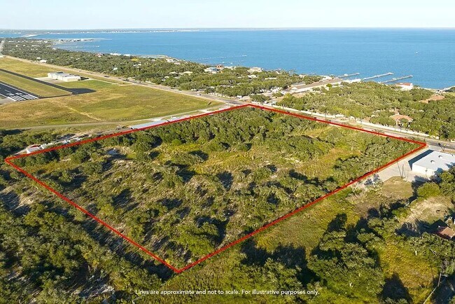
4131 Highway 35 N, Rockport, TX 78382


Property Detail
4131 Highway 35 N
Corpus Christi, TX
FULTON OUTLOTS, LOT N/2 OF 8 ALL OF 9 THRU 11 & S/2 OF 12 - WEST OF HWY 35, ACRES 13.5634
R50529
ARANSAS
Residentialacreage
Texas
B and X Area of moderate flood hazard, usually the area between the limits of the 100-year and 500-year floods.
13.56 AC
2025
Rockport/N Aransas
2025
Corpus Christi
950102
NEARBY LISTINGS FOR SALE OR LEASE
DEMOGRAPHICS near 4131 Highway 35 N
1 mile
3 mile
5 mile
2025 Total Population
356
8,671
17,839
2030 Population
351
9,058
18,797
Pop Growth 2025-2030
(1.40%)
+ 4.46%
+ 5.37%
Average Age
53
52
48
2025 Total Households
183
4,069
7,826
HH Growth 2025-2030
(0.55%)
+ 5.16%
+ 5.89%
Median Household Inc
$78,030
$74,664
$63,838
Avg Household Size
1.90
2.10
2.20
2025 Avg HH Vehicles
2.00
2.00
2.00
Median Home Value
$303,409
$346,354
$287,374
Median Year Built
1985
1995
1992
Nearby Places
Map Layers
Map Styles
 Street
 Aerial
Layers
 Traffic
 Biking
Places
Listings with unknown addresses are not visible on the map
- Restaurants
- Banks
- Shops
- Fitness
- Groceries
SALE & LEASE HISTORY
LISTING DATE
SALE/LEASE

May 07, 2022
For Sale
Dec 13, 2023
For Sale
Nearby Properties
Address
Land Use
TOTAL SIZE
Lot Size
Zoning
Address
Land Use
TOTAL SIZE
Lot Size
Zoning
395,335 SF
57.39 AC
Address
Land Use
TOTAL SIZE
Lot Size
Zoning
100,891 SF
7.78 AC
Address
Land Use
TOTAL SIZE
Lot Size
Zoning
32,302 SF
14.42 AC
Address
Land Use
TOTAL SIZE
Lot Size
Zoning
125,197 SF
14.61 AC
Address
Land Use
TOTAL SIZE
Lot Size
Zoning
79,033 SF
649.69 AC
Address
Land Use
TOTAL SIZE
Lot Size
Zoning
75,772 SF
13.74 AC
Address
Land Use
TOTAL SIZE
Lot Size
Zoning
126,886 AC
Address
Land Use
TOTAL SIZE
Lot Size
Zoning
288 SF
129.13 AC
Address
Land Use
TOTAL SIZE
Lot Size
Zoning
47,169 SF
85.55 AC
Address
Land Use
TOTAL SIZE
Lot Size
Zoning
33,524 SF
2.06 AC
Address
Land Use
TOTAL SIZE
Lot Size
Zoning
155,264 SF
21.60 AC
Address
Land Use
TOTAL SIZE
Lot Size
Zoning
18,998 SF
20 AC
Address
Land Use
TOTAL SIZE
Lot Size
Zoning
2,980 SF
47.98 AC
Address
Land Use
TOTAL SIZE
Lot Size
Zoning
59,220 AC
Address
Land Use
TOTAL SIZE
Lot Size
Zoning
41,075 SF
11.93 AC
Address
Land Use
TOTAL SIZE
Lot Size
Zoning
152.58 AC
Address
Land Use
TOTAL SIZE
Lot Size
Zoning
91,025 SF
8.22 AC
Address
Land Use
TOTAL SIZE
Lot Size
Zoning
16,791 SF
2.65 AC
Address
Land Use
TOTAL SIZE
Lot Size
Zoning
14,925 SF
1.66 AC
Address
Land Use
TOTAL SIZE
Lot Size
Zoning
68,265 SF
8.15 AC
Address
Land Use
TOTAL SIZE
Lot Size
Zoning
9,886 SF
7.96 AC
Address
Land Use
TOTAL SIZE
Lot Size
Zoning
12,072 SF
126.99 AC
Address
Land Use
TOTAL SIZE
Lot Size
Zoning
13,518 SF
1.82 AC
Address
Land Use
TOTAL SIZE
Lot Size
Zoning
2,739 SF
117.62 AC
Address
Land Use
TOTAL SIZE
Lot Size
Zoning
14,770 SF
1.92 AC
Address
Land Use
TOTAL SIZE
Lot Size
Zoning
17,370 SF
10.10 AC
Address
Land Use
TOTAL SIZE
Lot Size
Zoning
3,917 SF
6.60 AC
Address
Land Use
TOTAL SIZE
Lot Size
Zoning
15,600 SF
3.11 AC
Address
Land Use
TOTAL SIZE
Lot Size
Zoning
21,676 SF
6.87 AC
Address
Land Use
TOTAL SIZE
Lot Size
Zoning
14,812 SF
10.35 AC
The World's #1 Commercial Real Estate Marketplace
Connect with us
© 2026 CoStar Group
The information above has been obtained from sources believed reliable. While we do not doubt its accuracy we have not verified it and make no guarantee, warranty or representation about it. It is your responsibility to independently confirm its accuracy and completeness. Any projections, opinions, assumptions, or estimates used are for example only and do not represent the current or future performance of the property. The value of this transaction to you depends on tax and other factors which should be evaluated by your tax, financial, and legal advisors. You and your advisors should conduct a careful, independent investigation of the property to determine to your satisfaction the suitability of the property for your needs.