Property Record
4131 Smith St, Bacliff, TX 77518
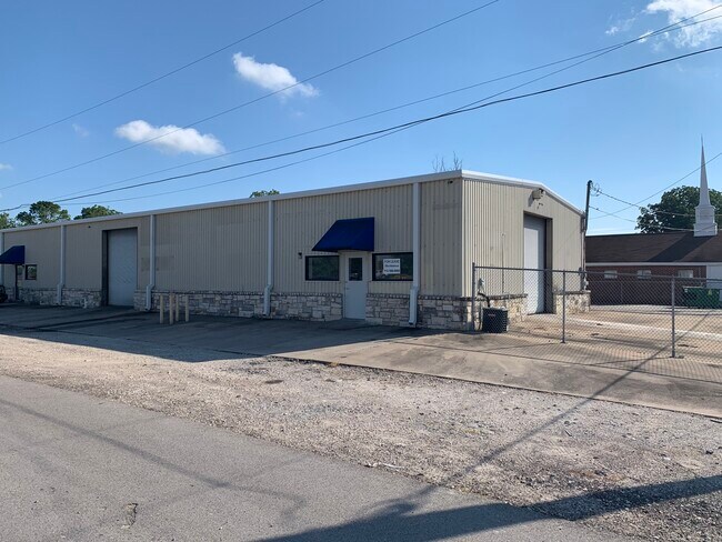


Property Detail
4131 Smith St
Houston-Pasadena-The Woodlands, TX
ABST 154 S G MCCLENNY SUR LOTS 22 THRU 32 BLK 42 BAY CLIFF
1295-0042-0022-000
Galveston
Commercialnec
Texas
C and X Area of minimal flood hazard, usually depicted on FIRMs as above the 500-year flood level.
22-32
2024
0.63 AC
2025
East-Southeast Far
721702
Houston
10,875 SF
NEARBY LISTINGS FOR SALE OR LEASE
DEMOGRAPHICS near 4131 Smith St
1 mile
3 mile
5 mile
2025 Total Population
10,150
31,493
89,804
2030 Population
10,581
32,553
93,006
Pop Growth 2025-2030
+ 4.25%
+ 3.37%
+ 3.57%
Average Age
37
37
39
2025 Total Households
3,485
11,061
33,605
HH Growth 2025-2030
+ 4.28%
+ 3.34%
+ 3.56%
Median Household Inc
$69,033
$96,635
$96,469
Avg Household Size
2.80
2.80
2.60
2025 Avg HH Vehicles
2.00
2.00
2.00
Median Home Value
$244,891
$314,707
$324,223
Median Year Built
1989
1997
1994
Nearby Places
Map Layers
Map Styles
 Street
 Aerial
Layers
 Traffic
 Biking
Places
Listings with unknown addresses are not visible on the map
- Restaurants
- Banks
- Shops
- Fitness
- Groceries
PUBLIC TRANSPORTATION
AIRPORT
William P Hobby
Drive
Walk
Distance
William P Hobby
39 min
24.4 mi
Freight Ports
Port of Galveston
Drive
Walk
Distance
Port of Galveston
26 min
21.2 mi
SALE & LEASE HISTORY
LISTING DATE
SALE/LEASE

Jun 16, 2020
For Lease
Jan 18, 2017
For Lease
Nearby Properties
Address
Land Use
TOTAL SIZE
Lot Size
Zoning
Address
Land Use
TOTAL SIZE
Lot Size
Zoning
500,000 SF
125.06 AC
Address
Land Use
TOTAL SIZE
Lot Size
Zoning
320,892 SF
15 AC
Address
Land Use
TOTAL SIZE
Lot Size
Zoning
372,456 SF
20.15 AC
Address
Land Use
TOTAL SIZE
Lot Size
Zoning
415,941 SF
14.35 AC
Address
Land Use
TOTAL SIZE
Lot Size
Zoning
291,161 SF
68.71 AC
Address
Land Use
TOTAL SIZE
Lot Size
Zoning
Address
Land Use
TOTAL SIZE
Lot Size
Zoning
38.73 AC
Address
Land Use
TOTAL SIZE
Lot Size
Zoning
181,500 SF
47.24 AC
Address
Land Use
TOTAL SIZE
Lot Size
Zoning
120,000 SF
23.37 AC
Address
Land Use
TOTAL SIZE
Lot Size
Zoning
254,503 SF
17.70 AC
Address
Land Use
TOTAL SIZE
Lot Size
Zoning
437,619 SF
29.38 AC
NONE
Address
Land Use
TOTAL SIZE
Lot Size
Zoning
90,291 SF
1.81 AC
Address
Land Use
TOTAL SIZE
Lot Size
Zoning
206,147 SF
20.51 AC
Address
Land Use
TOTAL SIZE
Lot Size
Zoning
79,018 SF
9.34 AC
Address
Land Use
TOTAL SIZE
Lot Size
Zoning
114,488 SF
20 AC
Address
Land Use
TOTAL SIZE
Lot Size
Zoning
171,990 SF
11.85 AC
Address
Land Use
TOTAL SIZE
Lot Size
Zoning
105,218 SF
4.91 AC
Address
Land Use
TOTAL SIZE
Lot Size
Zoning
60,216 SF
5.99 AC
Address
Land Use
TOTAL SIZE
Lot Size
Zoning
130,457 SF
14.12 AC
Address
Land Use
TOTAL SIZE
Lot Size
Zoning
121,266 SF
9.09 AC
Address
Land Use
TOTAL SIZE
Lot Size
Zoning
98,011 SF
13.88 AC
Address
Land Use
TOTAL SIZE
Lot Size
Zoning
94,720 SF
10.73 AC
Address
Land Use
TOTAL SIZE
Lot Size
Zoning
137,088 SF
10.08 AC
Address
Land Use
TOTAL SIZE
Lot Size
Zoning
95,882 SF
5.41 AC
Address
Land Use
TOTAL SIZE
Lot Size
Zoning
107,500 SF
10.02 AC
Address
Land Use
TOTAL SIZE
Lot Size
Zoning
103,138 SF
4.84 AC
Address
Land Use
TOTAL SIZE
Lot Size
Zoning
82,342 SF
7.78 AC
Address
Land Use
TOTAL SIZE
Lot Size
Zoning
33,788 SF
3.06 AC
Address
Land Use
TOTAL SIZE
Lot Size
Zoning
Address
Land Use
TOTAL SIZE
Lot Size
Zoning
23,764 SF
2.36 AC
The World's #1 Commercial Real Estate Marketplace
Connect with us
© 2026 CoStar Group
The information above has been obtained from sources believed reliable. While we do not doubt its accuracy we have not verified it and make no guarantee, warranty or representation about it. It is your responsibility to independently confirm its accuracy and completeness. Any projections, opinions, assumptions, or estimates used are for example only and do not represent the current or future performance of the property. The value of this transaction to you depends on tax and other factors which should be evaluated by your tax, financial, and legal advisors. You and your advisors should conduct a careful, independent investigation of the property to determine to your satisfaction the suitability of the property for your needs.