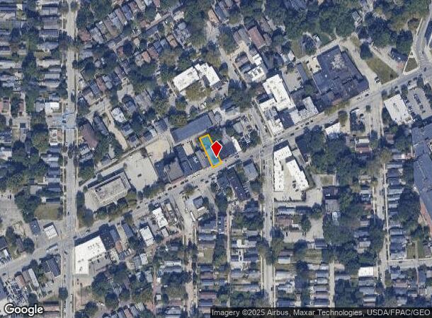
Property Record
4134 Lorain Ave, Cleveland, OH 44113
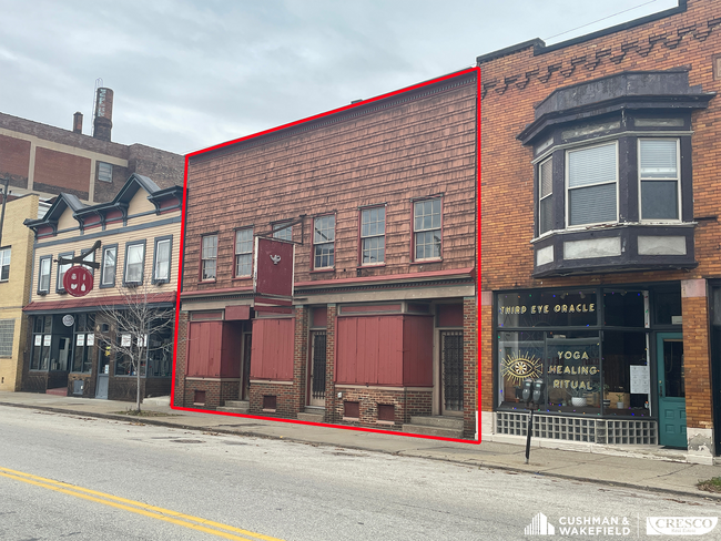
This Property Is For Sale
NEARBY LISTINGS FOR SALE OR LEASE
-
-
-
-
-
-
-
-
-
-
-
-
-
-
-
No Photo
-
-
View all Cleveland listings for sale on LoopNet.com
Property Detail
4134 Lorain Ave
Cleveland-Elyria, OH
Sargent
003-35-070
52 S&D 0005 ALL
Storebuilding
Cuyahoga
X
Ohio
39035C0177F
5
2024
0.12 AC
2024
West
103500
Cleveland
6,688 SF
DEMOGRAPHICS near 4134 Lorain Ave
1 Mile
3 Mile
5 Mile
2024 Total Population
19,372
114,288
268,721
2029 Population
19,089
111,665
261,429
Pop Growth 2024-2029
(1.46%)
(2.30%)
(2.71%)
Average Age
38
36
38
2024 Total Households
9,728
53,677
123,718
HH Growth 2024-2029
(1.32%)
(1.93%)
(2.65%)
Median Household Inc
$47,056
$40,650
$42,302
Avg Household Size
1.90
2.00
2.00
2024 Avg HH Vehicles
1.00
1.00
1.00
Median Home Value
$244,683
$119,264
$121,932
Median Year Built
1947
1947
1948
Nearby Places
- Restaurants
- Banks
- Shops
- Fitness
- Groceries
PUBLIC TRANSPORTATION
TRANSIT/SUBWAY
West 25 - Ohio City (Red Line - Greater Cleveland Regional Transit Authority Rapid Transit (The Rapid))
DRIVE
WALK
Distance
West 25 - Ohio City (Red Line - Greater Cleveland Regional Transit Authority Rapid Transit (The Rapid))
2 min
15 min
0.7 mi
West 65 - Lorain (Red Line - Greater Cleveland Regional Transit Authority Rapid Transit (The Rapid))
DRIVE
WALK
Distance
West 65 - Lorain (Red Line - Greater Cleveland Regional Transit Authority Rapid Transit (The Rapid))
3 min
18 min
0.9 mi
COMMUTER RAIL
Cleveland Lakefront Station (Blue Line - Greater Cleveland Regional Transit Authority Rapid Transit (The Rapid), Green Line - Greater Cleveland Regional Transit Authority Rapid Transit (The Rapid))
DRIVE
WALK
Distance
Cleveland Lakefront Station (Blue Line - Greater Cleveland Regional Transit Authority Rapid Transit (The Rapid), Green Line - Greater Cleveland Regional Transit Authority Rapid Transit (The Rapid))
10 min
3.5 mi
AIRPORT
Cleveland-Hopkins International
DRIVE
WALK
Distance
Cleveland-Hopkins International
21 min
11.4 mi
Nearby Properties
Address
Land Use
TOTAL SIZE
Lot Size
Zoning
Address
Land Use
TOTAL SIZE
Lot Size
Zoning
3,491,901 SF
34.32 AC
Address
Land Use
TOTAL SIZE
Lot Size
Zoning
753,970 SF
9.31 AC
GR
Address
Land Use
TOTAL SIZE
Lot Size
Zoning
1,570,958 SF
1.33 AC
GR
Address
Land Use
TOTAL SIZE
Lot Size
Zoning
17.45 AC
GI
Address
Land Use
TOTAL SIZE
Lot Size
Zoning
16.78 AC
SI
Address
Land Use
TOTAL SIZE
Lot Size
Zoning
710,780 SF
4.33 AC
GR
Address
Land Use
TOTAL SIZE
Lot Size
Zoning
765,607 SF
12.15 AC
GR
Address
Land Use
TOTAL SIZE
Lot Size
Zoning
788,580 SF
4.85 AC
GR
Address
Land Use
TOTAL SIZE
Lot Size
Zoning
434,475 SF
0.53 AC
Address
Land Use
TOTAL SIZE
Lot Size
Zoning
1,191,268 SF
3.94 AC
SI
Address
Land Use
TOTAL SIZE
Lot Size
Zoning
6.98 AC
SI
Address
Land Use
TOTAL SIZE
Lot Size
Zoning
148,486 SF
489.21 AC
GI
Address
Land Use
TOTAL SIZE
Lot Size
Zoning
5,100 SF
9.41 AC
GI
Address
Land Use
TOTAL SIZE
Lot Size
Zoning
652,455 SF
2.04 AC
GR
Address
Land Use
TOTAL SIZE
Lot Size
Zoning
263,723 SF
7.48 AC
GI
Address
Land Use
TOTAL SIZE
Lot Size
Zoning
1,130,924 SF
4.02 AC
SI
Address
Land Use
TOTAL SIZE
Lot Size
Zoning
299,515 SF
1.30 AC
GR
Address
Land Use
TOTAL SIZE
Lot Size
Zoning
1,181,536 SF
27.82 AC
RO
Address
Land Use
TOTAL SIZE
Lot Size
Zoning
228,154 SF
0.48 AC
GR
Address
Land Use
TOTAL SIZE
Lot Size
Zoning
3.23 AC
LLR
Address
Land Use
TOTAL SIZE
Lot Size
Zoning
2.74 AC
Address
Land Use
TOTAL SIZE
Lot Size
Zoning
1,003,787 SF
2.12 AC
GR
Address
Land Use
TOTAL SIZE
Lot Size
Zoning
1,467,599 SF
1.66 AC
GR
Address
Land Use
TOTAL SIZE
Lot Size
Zoning
758,394 SF
2.25 AC
GR
Address
Land Use
TOTAL SIZE
Lot Size
Zoning
493,911 SF
1.88 AC
LLR
Address
Land Use
TOTAL SIZE
Lot Size
Zoning
257,857 SF
8.03 AC
GR
Address
Land Use
TOTAL SIZE
Lot Size
Zoning
1.53 AC
LLR
Address
Land Use
TOTAL SIZE
Lot Size
Zoning
299,507 SF
2.14 AC
LR
Address
Land Use
TOTAL SIZE
Lot Size
Zoning
194,478 SF
9.61 AC
SI
Address
Land Use
TOTAL SIZE
Lot Size
Zoning
2.83 AC
LLR
The World's #1 Commercial Real Estate Marketplace
Connect with us
© 2025 CoStar Group
The information above has been obtained from sources believed reliable. While we do not doubt its accuracy we have not verified it and make no guarantee, warranty or representation about it. It is your responsibility to independently confirm its accuracy and completeness. Any projections, opinions, assumptions, or estimates used are for example only and do not represent the current or future performance of the property. The value of this transaction to you depends on tax and other factors which should be evaluated by your tax, financial, and legal advisors. You and your advisors should conduct a careful, independent investigation of the property to determine to your satisfaction the suitability of the property for your needs.