Property Record
41347 S Range Rd, Ponchatoula, LA 70454
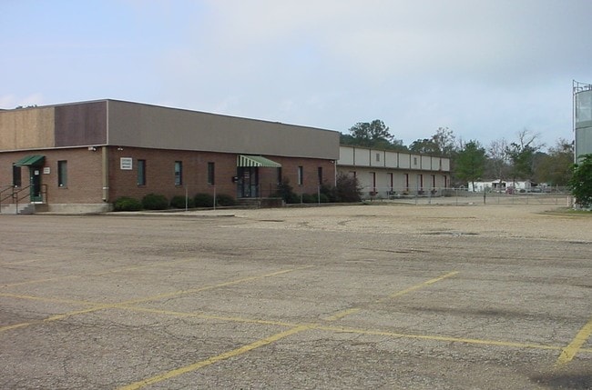

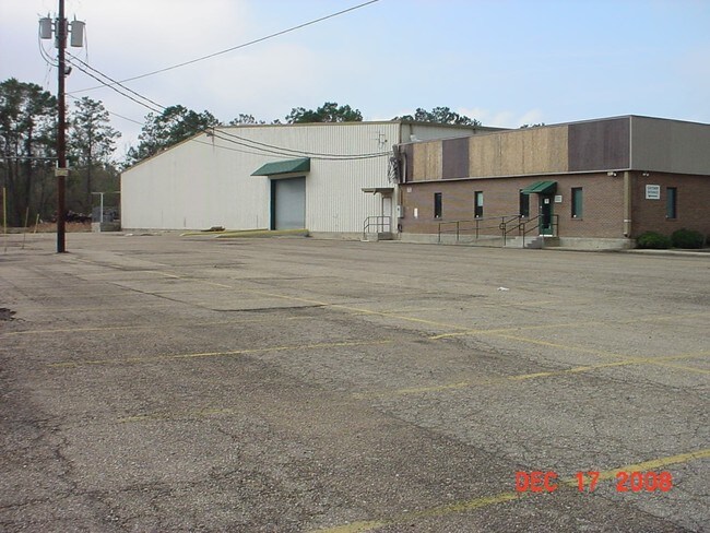

Property Detail
41347 S Range Rd
01761005
11.02A TOTAL 10.80 A IN W12 OF NW14 OF SEC 7 T7SR8E B309 P545 B643 P870 B776 P544-560 MAP 776543 0.22A IN SEC 7 T7SR8E B656 P
Commercialnec
Tangipahoa
B and X Area of moderate flood hazard, usually the area between the limits of the 100-year and 500-year floods.
Louisiana
2025
11.02 AC
2025
Louisiana South Area
954504
Other Market Areas
80,000 SF
Hammond, LA
NEARBY LISTINGS FOR SALE OR LEASE
DEMOGRAPHICS near 41347 S Range Rd
1 mile
3 mile
5 mile
2025 Total Population
4,525
26,961
59,925
2030 Population
4,687
28,001
62,320
Pop Growth 2025-2030
+ 3.58%
+ 3.86%
+ 4.00%
Average Age
39
39
38
2025 Total Households
1,783
10,724
23,156
HH Growth 2025-2030
+ 3.70%
+ 4.02%
+ 4.23%
Median Household Inc
$70,320
$56,883
$56,099
Avg Household Size
2.50
2.40
2.40
2025 Avg HH Vehicles
2.00
2.00
2.00
Median Home Value
$216,986
$227,358
$239,145
Median Year Built
2002
2000
1997
Nearby Places
Map Layers
Map Styles
 Street
 Aerial
Layers
 Traffic
 Biking
Places
Listings with unknown addresses are not visible on the map
- Restaurants
- Banks
- Shops
- Fitness
- Groceries
PUBLIC TRANSPORTATION
COMMUTER RAIL
Hammond Amtrak Station (City of New Orleans - Amtrak)
Drive
Walk
Distance
Hammond Amtrak Station (City of New Orleans - Amtrak)
9 min
4.3 mi
Freight Ports
Port of New Orleans
Drive
Walk
Distance
Port of New Orleans
71 min
54.5 mi
SALE & LEASE HISTORY
LISTING DATE
SALE/LEASE

Apr 12, 2019
For Lease
Nearby Properties
Address
Land Use
TOTAL SIZE
Lot Size
Zoning
Address
Land Use
TOTAL SIZE
Lot Size
Zoning
124,912 SF
12.50 AC
Address
Land Use
TOTAL SIZE
Lot Size
Zoning
22.56 AC
Address
Land Use
TOTAL SIZE
Lot Size
Zoning
Address
Land Use
TOTAL SIZE
Lot Size
Zoning
170,004 SF
17.06 AC
Address
Land Use
TOTAL SIZE
Lot Size
Zoning
327,625 SF
14.78 AC
Address
Land Use
TOTAL SIZE
Lot Size
Zoning
152,841 SF
20.69 AC
Address
Land Use
TOTAL SIZE
Lot Size
Zoning
84,000 SF
8.32 AC
Address
Land Use
TOTAL SIZE
Lot Size
Zoning
82,860 SF
11.42 AC
Address
Land Use
TOTAL SIZE
Lot Size
Zoning
24,931 SF
2.67 AC
Address
Land Use
TOTAL SIZE
Lot Size
Zoning
24,823 SF
3 AC
Address
Land Use
TOTAL SIZE
Lot Size
Zoning
61,000 SF
11.91 AC
Address
Land Use
TOTAL SIZE
Lot Size
Zoning
432 SF
14.80 AC
Address
Land Use
TOTAL SIZE
Lot Size
Zoning
127,380 SF
9.70 AC
Address
Land Use
TOTAL SIZE
Lot Size
Zoning
36,593 SF
1.54 AC
Address
Land Use
TOTAL SIZE
Lot Size
Zoning
73,922 SF
9.99 AC
Address
Land Use
TOTAL SIZE
Lot Size
Zoning
36,000 SF
17.87 AC
Address
Land Use
TOTAL SIZE
Lot Size
Zoning
108,000 SF
9.78 AC
Address
Land Use
TOTAL SIZE
Lot Size
Zoning
22,000 SF
5.56 AC
Address
Land Use
TOTAL SIZE
Lot Size
Zoning
27,215 SF
7.58 AC
Address
Land Use
TOTAL SIZE
Lot Size
Zoning
47,960 SF
9.16 AC
Address
Land Use
TOTAL SIZE
Lot Size
Zoning
96,064 SF
5.03 AC
Address
Land Use
TOTAL SIZE
Lot Size
Zoning
85,430 SF
6.44 AC
Address
Land Use
TOTAL SIZE
Lot Size
Zoning
60,480 SF
7.28 AC
Address
Land Use
TOTAL SIZE
Lot Size
Zoning
20,128 SF
20.77 AC
Address
Land Use
TOTAL SIZE
Lot Size
Zoning
22,507 SF
0.63 AC
Address
Land Use
TOTAL SIZE
Lot Size
Zoning
43,595 SF
10.17 AC
Address
Land Use
TOTAL SIZE
Lot Size
Zoning
35,100 SF
3.20 AC
Address
Land Use
TOTAL SIZE
Lot Size
Zoning
90,605 SF
9.76 AC
Address
Land Use
TOTAL SIZE
Lot Size
Zoning
71,300 SF
7.02 AC
Address
Land Use
TOTAL SIZE
Lot Size
Zoning
120,800 SF
10 AC
The World's #1 Commercial Real Estate Marketplace
Connect with us
© 2026 CoStar Group
The information above has been obtained from sources believed reliable. While we do not doubt its accuracy we have not verified it and make no guarantee, warranty or representation about it. It is your responsibility to independently confirm its accuracy and completeness. Any projections, opinions, assumptions, or estimates used are for example only and do not represent the current or future performance of the property. The value of this transaction to you depends on tax and other factors which should be evaluated by your tax, financial, and legal advisors. You and your advisors should conduct a careful, independent investigation of the property to determine to your satisfaction the suitability of the property for your needs.