Property Record
4136 River Rd, Cincinnati, OH 45204
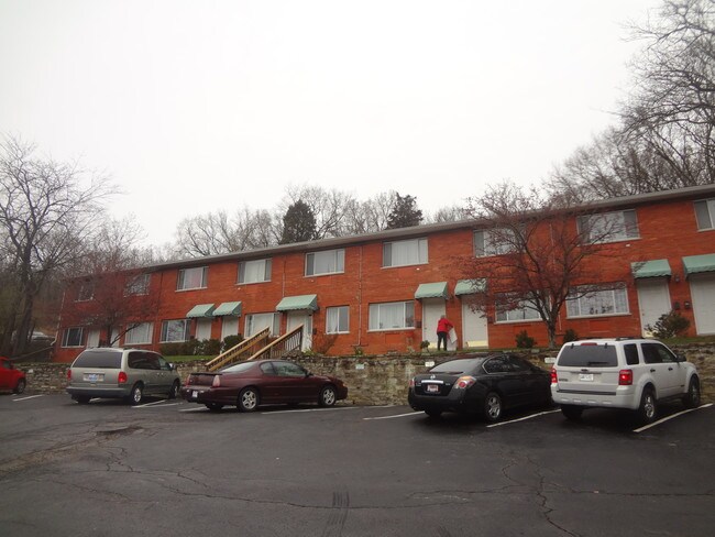

Property Detail
4136 River Rd
160-0071-0008
NS RIVER RD 137.69 X 287.17 PT LOT 2 L GEISSLERS SUB
Apartment
Hamilton
RM20
Ohio
AE The base floodplain where base flood elevations are provided. AE Zones are now used on new format FIRMs instead of A1-A30 Zones.
2
2025
0.90 AC
2025
Riverside
010400
Cincinnati/Dayton
6,960 SF
Cincinnati, OH-KY-IN
NEARBY LISTINGS FOR SALE OR LEASE
-
-
View all Cincinnati listings for sale on LoopNet.com
DEMOGRAPHICS near 4136 River Rd
1 mile
3 mile
5 mile
2025 Total Population
5,771
56,081
174,220
2030 Population
5,771
57,023
177,764
Pop Growth 2025-2030
0.00%
+ 1.68%
+ 2.03%
Average Age
41
40
39
2025 Total Households
2,367
21,955
70,724
HH Growth 2025-2030
+ 0.13%
+ 1.69%
+ 2.08%
Median Household Inc
$81,906
$75,273
$67,027
Avg Household Size
2.40
2.50
2.40
2025 Avg HH Vehicles
2.00
2.00
2.00
Median Home Value
$222,651
$212,063
$218,888
Median Year Built
1973
1967
1964
Nearby Places
Map Layers
Map Styles
 Street
 Aerial
Transit
 Traffic
 Biking
Places
Listings with unknown addresses are not visible on the map
- Restaurants
- Banks
- Shops
- Fitness
- Groceries
PUBLIC TRANSPORTATION
COMMUTER RAIL
Cincinnati Union Terminal (Cardinal - Amtrak)
Drive
Walk
Distance
Cincinnati Union Terminal (Cardinal - Amtrak)
12 min
6.2 mi
AIRPORT
Cincinnati/Northern Kentucky International
Drive
Walk
Distance
Cincinnati/Northern Kentucky International
33 min
5.2 mi
Freight Ports
Port of Toledo
Drive
Walk
Distance
Port of Toledo
250 min
211.0 mi
SALE & LEASE HISTORY
LISTING DATE
SALE/LEASE

Sep 11, 2019
For Sale
Dec 13, 2019
For Sale
Nearby Properties
Address
Land Use
TOTAL SIZE
Lot Size
Zoning
Address
Land Use
TOTAL SIZE
Lot Size
Zoning
4,150.90 AC
Address
Land Use
TOTAL SIZE
Lot Size
Zoning
82.25 AC
Address
Land Use
TOTAL SIZE
Lot Size
Zoning
157.77 AC
Address
Land Use
TOTAL SIZE
Lot Size
Zoning
46.68 AC
Address
Land Use
TOTAL SIZE
Lot Size
Zoning
20.38 AC
Address
Land Use
TOTAL SIZE
Lot Size
Zoning
177,092 SF
8.64 AC
Address
Land Use
TOTAL SIZE
Lot Size
Zoning
38.97 AC
Address
Land Use
TOTAL SIZE
Lot Size
Zoning
12.85 AC
Address
Land Use
TOTAL SIZE
Lot Size
Zoning
769,604 SF
14 AC
Address
Land Use
TOTAL SIZE
Lot Size
Zoning
64,481 SF
16.99 AC
Address
Land Use
TOTAL SIZE
Lot Size
Zoning
177,200 SF
16.27 AC
Address
Land Use
TOTAL SIZE
Lot Size
Zoning
26.62 AC
Address
Land Use
TOTAL SIZE
Lot Size
Zoning
157,520 SF
18.05 AC
Address
Land Use
TOTAL SIZE
Lot Size
Zoning
50,536 SF
34.12 AC
Address
Land Use
TOTAL SIZE
Lot Size
Zoning
99.35 AC
Address
Land Use
TOTAL SIZE
Lot Size
Zoning
493,680 SF
25 AC
Address
Land Use
TOTAL SIZE
Lot Size
Zoning
16,406 SF
223.20 AC
Address
Land Use
TOTAL SIZE
Lot Size
Zoning
458,800 SF
49.35 AC
Address
Land Use
TOTAL SIZE
Lot Size
Zoning
85,726 SF
15.07 AC
Address
Land Use
TOTAL SIZE
Lot Size
Zoning
30.43 AC
AA
Address
Land Use
TOTAL SIZE
Lot Size
Zoning
426,420 SF
20.59 AC
Address
Land Use
TOTAL SIZE
Lot Size
Zoning
194,304 SF
15.77 AC
Address
Land Use
TOTAL SIZE
Lot Size
Zoning
326,000 SF
19.16 AC
Address
Land Use
TOTAL SIZE
Lot Size
Zoning
Address
Land Use
TOTAL SIZE
Lot Size
Zoning
8.27 AC
Address
Land Use
TOTAL SIZE
Lot Size
Zoning
66,040 SF
22.34 AC
Address
Land Use
TOTAL SIZE
Lot Size
Zoning
5.89 AC
Address
Land Use
TOTAL SIZE
Lot Size
Zoning
316,800 SF
15.66 AC
Address
Land Use
TOTAL SIZE
Lot Size
Zoning
14.86 AC
Address
Land Use
TOTAL SIZE
Lot Size
Zoning
1,132,632 SF
7.11 AC
The World's #1 Commercial Real Estate Marketplace
Connect with us
© 2026 CoStar Group
The information above has been obtained from sources believed reliable. While we do not doubt its accuracy we have not verified it and make no guarantee, warranty or representation about it. It is your responsibility to independently confirm its accuracy and completeness. Any projections, opinions, assumptions, or estimates used are for example only and do not represent the current or future performance of the property. The value of this transaction to you depends on tax and other factors which should be evaluated by your tax, financial, and legal advisors. You and your advisors should conduct a careful, independent investigation of the property to determine to your satisfaction the suitability of the property for your needs.