Property Record
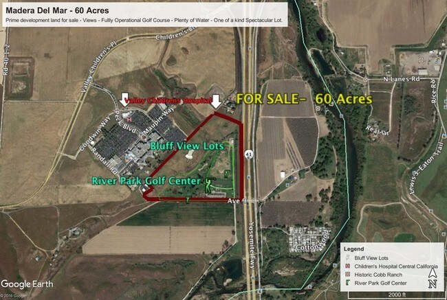
41389 Avenue 9, Fresno, CA 93720


NEARBY LISTINGS FOR SALE OR LEASE
Property Detail
41389 Avenue 9
049-085-015
SEC 16 T12S R20E
Commercialnec
Madera
X
California
06019C1020H
57.03 AC
2024
Outlying Madera County
2025
Fresno
005507
Madera, CA
2,835 SF
DEMOGRAPHICS near 41389 Avenue 9
1 Mile
3 Mile
5 Mile
2024 Total Population
719
49,464
140,040
2029 Population
763
51,112
143,584
Pop Growth 2024-2029
+ 6.12%
+ 3.33%
+ 2.53%
Average Age
42
40
40
2024 Total Households
275
19,296
54,107
HH Growth 2024-2029
+ 5.82%
+ 3.16%
+ 2.46%
Median Household Inc
$166,025
$108,236
$92,759
Avg Household Size
2.60
2.50
2.50
2024 Avg HH Vehicles
2.00
2.00
2.00
Median Home Value
$552,325
$468,311
$427,126
Median Year Built
1990
1992
1988
Nearby Places
Map Layers
Map Styles
 Street
 Aerial
- Restaurants
- Banks
- Shops
- Fitness
- Groceries
PUBLIC TRANSPORTATION
AIRPORT
Fresno Yosemite International
DRIVE
WALK
Distance
Fresno Yosemite International
22 min
14.0 mi
Freight Ports
Port of Stockton
DRIVE
WALK
Distance
Port of Stockton
157 min
124.5 mi
SALE & LEASE HISTORY
LISTING DATE
SALE/LEASE

Apr 01, 2017
For Sale
Nearby Properties
Address
Land Use
TOTAL SIZE
Lot Size
Zoning
Address
Land Use
TOTAL SIZE
Lot Size
Zoning
39.39 AC
Address
Land Use
TOTAL SIZE
Lot Size
Zoning
413,093 SF
33.19 AC
CP
Address
Land Use
TOTAL SIZE
Lot Size
Zoning
143,370 SF
6.92 AC
CP
Address
Land Use
TOTAL SIZE
Lot Size
Zoning
180,161 SF
10.38 AC
Address
Land Use
TOTAL SIZE
Lot Size
Zoning
119,869 SF
11.08 AC
C1
Address
Land Use
TOTAL SIZE
Lot Size
Zoning
328,887 SF
16.34 AC
R3
Address
Land Use
TOTAL SIZE
Lot Size
Zoning
212,354 SF
13.12 AC
R2
Address
Land Use
TOTAL SIZE
Lot Size
Zoning
188,177 SF
5.58 AC
CP
Address
Land Use
TOTAL SIZE
Lot Size
Zoning
181,538 SF
0.01 AC
CP
Address
Land Use
TOTAL SIZE
Lot Size
Zoning
104,902 SF
8 AC
C6
Address
Land Use
TOTAL SIZE
Lot Size
Zoning
251,904 SF
16.70 AC
SPLIT
Address
Land Use
TOTAL SIZE
Lot Size
Zoning
200,826 SF
19.23 AC
R2
Address
Land Use
TOTAL SIZE
Lot Size
Zoning
152,550 SF
9.23 AC
R3
Address
Land Use
TOTAL SIZE
Lot Size
Zoning
78,774 SF
2.10 AC
CP
Address
Land Use
TOTAL SIZE
Lot Size
Zoning
8.80 AC
AE5
Address
Land Use
TOTAL SIZE
Lot Size
Zoning
105,916 SF
2.61 AC
C6
Address
Land Use
TOTAL SIZE
Lot Size
Zoning
137,094 SF
4.88 AC
CM
Address
Land Use
TOTAL SIZE
Lot Size
Zoning
117,490 SF
0.01 AC
CP
Address
Land Use
TOTAL SIZE
Lot Size
Zoning
122,486 SF
6.24 AC
CP
Address
Land Use
TOTAL SIZE
Lot Size
Zoning
70,678 SF
4.23 AC
Address
Land Use
TOTAL SIZE
Lot Size
Zoning
152,392 SF
14.95 AC
C6
Address
Land Use
TOTAL SIZE
Lot Size
Zoning
98,530 SF
9.26 AC
RP
Address
Land Use
TOTAL SIZE
Lot Size
Zoning
67,677 SF
4 AC
CP
Address
Land Use
TOTAL SIZE
Lot Size
Zoning
126,286 SF
9.60 AC
C6
Address
Land Use
TOTAL SIZE
Lot Size
Zoning
66,859 SF
1.99 AC
SPLIT
Address
Land Use
TOTAL SIZE
Lot Size
Zoning
42,166 SF
1.63 AC
CM
Address
Land Use
TOTAL SIZE
Lot Size
Zoning
67,677 SF
3.72 AC
CP
The World's #1 Commercial Real Estate Marketplace
Connect with us
© 2026 CoStar Group
The information above has been obtained from sources believed reliable. While we do not doubt its accuracy we have not verified it and make no guarantee, warranty or representation about it. It is your responsibility to independently confirm its accuracy and completeness. Any projections, opinions, assumptions, or estimates used are for example only and do not represent the current or future performance of the property. The value of this transaction to you depends on tax and other factors which should be evaluated by your tax, financial, and legal advisors. You and your advisors should conduct a careful, independent investigation of the property to determine to your satisfaction the suitability of the property for your needs.