Property Record
414 Bemis Rd, Saline, MI 48176
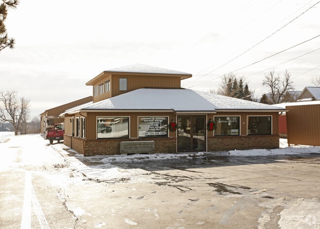

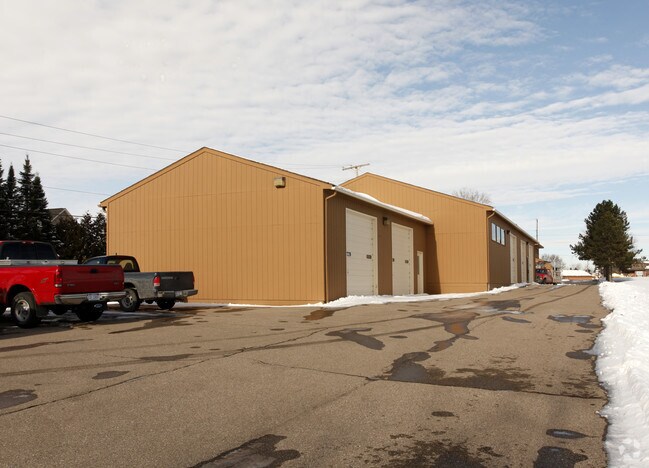
Property Detail
414 Bemis Rd
19-06-226-001
E4RODS LOT 45
Commercialnec
Washtenaw
C-2
Michigan
B and X Area of moderate flood hazard, usually the area between the limits of the 100-year and 500-year floods.
45
2025
0.95 AC
2025
Washtenaw W of 23
423600
Detroit
8,784 SF
Ann Arbor, MI
NEARBY LISTINGS FOR SALE OR LEASE
DEMOGRAPHICS near 414 Bemis Rd
1 mile
3 mile
5 mile
2025 Total Population
4,952
21,140
37,750
2030 Population
4,988
21,372
38,143
Pop Growth 2025-2030
+ 0.73%
+ 1.10%
+ 1.04%
Average Age
43
43
42
2025 Total Households
2,254
8,126
14,356
HH Growth 2025-2030
+ 1.11%
+ 1.23%
+ 1.07%
Median Household Inc
$77,611
$113,067
$118,307
Avg Household Size
2.20
2.60
2.50
2025 Avg HH Vehicles
2.00
2.00
2.00
Median Home Value
$281,420
$410,580
$416,950
Median Year Built
1971
1985
1992
Nearby Places
Map Layers
Map Styles
 Street
 Aerial
Layers
 Traffic
 Biking
Places
Listings with unknown addresses are not visible on the map
- Restaurants
- Banks
- Shops
- Fitness
- Groceries
PUBLIC TRANSPORTATION
COMMUTER RAIL
Ann Arbor Amtrak Station (Wolverine - Amtrak)
Drive
Walk
Distance
Ann Arbor Amtrak Station (Wolverine - Amtrak)
19 min
9.3 mi
AIRPORT
Detroit Metro Wayne County
Drive
Walk
Distance
Detroit Metro Wayne County
35 min
26.6 mi
Freight Ports
Port of Toledo
Drive
Walk
Distance
Port of Toledo
72 min
54.1 mi
Nearby Properties
Address
Land Use
TOTAL SIZE
Lot Size
Zoning
Address
Land Use
TOTAL SIZE
Lot Size
Zoning
253,702 SF
30.23 AC
Address
Land Use
TOTAL SIZE
Lot Size
Zoning
167,294 SF
40.67 AC
Address
Land Use
TOTAL SIZE
Lot Size
Zoning
105,615 SF
26.31 AC
Address
Land Use
TOTAL SIZE
Lot Size
Zoning
283,484 SF
22.64 AC
R-3
Address
Land Use
TOTAL SIZE
Lot Size
Zoning
1,562,480 SF
189.08 AC
I-4
Address
Land Use
TOTAL SIZE
Lot Size
Zoning
191,215 SF
30.23 AC
Address
Land Use
TOTAL SIZE
Lot Size
Zoning
99,663 SF
6.89 AC
R-1A
Address
Land Use
TOTAL SIZE
Lot Size
Zoning
99,000 SF
12.22 AC
I-2
Address
Land Use
TOTAL SIZE
Lot Size
Zoning
140,284 SF
6.83 AC
I-2
Address
Land Use
TOTAL SIZE
Lot Size
Zoning
65,899 SF
6.37 AC
R-3
Address
Land Use
TOTAL SIZE
Lot Size
Zoning
8,340 SF
322.91 AC
PUD
Address
Land Use
TOTAL SIZE
Lot Size
Zoning
8,340 SF
440.85 AC
PUD
Address
Land Use
TOTAL SIZE
Lot Size
Zoning
179,324 SF
14.91 AC
I-2
Address
Land Use
TOTAL SIZE
Lot Size
Zoning
105,418 SF
9.47 AC
I-2
Address
Land Use
TOTAL SIZE
Lot Size
Zoning
86,859 SF
12.33 AC
SPA-1
Address
Land Use
TOTAL SIZE
Lot Size
Zoning
53,876 SF
SPA-1
Address
Land Use
TOTAL SIZE
Lot Size
Zoning
135,417 SF
8.19 AC
I-2
Address
Land Use
TOTAL SIZE
Lot Size
Zoning
8.80 AC
I-2
Address
Land Use
TOTAL SIZE
Lot Size
Zoning
33,000 SF
I-2
Address
Land Use
TOTAL SIZE
Lot Size
Zoning
49,311 SF
4.90 AC
SPA-1
Address
Land Use
TOTAL SIZE
Lot Size
Zoning
53,244 SF
8.10 AC
SPA-1
Address
Land Use
TOTAL SIZE
Lot Size
Zoning
76,690 SF
8.82 AC
I-2
Address
Land Use
TOTAL SIZE
Lot Size
Zoning
27,258 SF
I-4
Address
Land Use
TOTAL SIZE
Lot Size
Zoning
32,361 SF
11.40 AC
II
Address
Land Use
TOTAL SIZE
Lot Size
Zoning
32,400 SF
5.16 AC
RI
Address
Land Use
TOTAL SIZE
Lot Size
Zoning
6,888 SF
65.56 AC
DH
Address
Land Use
TOTAL SIZE
Lot Size
Zoning
43,500 SF
I-2
Address
Land Use
TOTAL SIZE
Lot Size
Zoning
111,816 SF
13.98 AC
I-2
Address
Land Use
TOTAL SIZE
Lot Size
Zoning
7,035 SF
4.58 AC
Address
Land Use
TOTAL SIZE
Lot Size
Zoning
69,916 SF
5 AC
I-2
The World's #1 Commercial Real Estate Marketplace
Connect with us
© 2026 CoStar Group
The information above has been obtained from sources believed reliable. While we do not doubt its accuracy we have not verified it and make no guarantee, warranty or representation about it. It is your responsibility to independently confirm its accuracy and completeness. Any projections, opinions, assumptions, or estimates used are for example only and do not represent the current or future performance of the property. The value of this transaction to you depends on tax and other factors which should be evaluated by your tax, financial, and legal advisors. You and your advisors should conduct a careful, independent investigation of the property to determine to your satisfaction the suitability of the property for your needs.