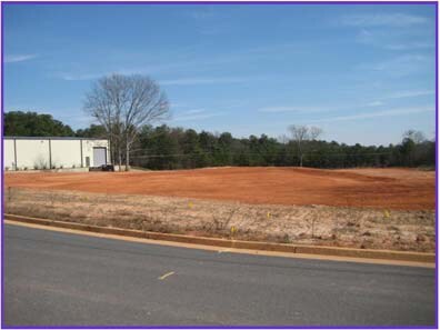
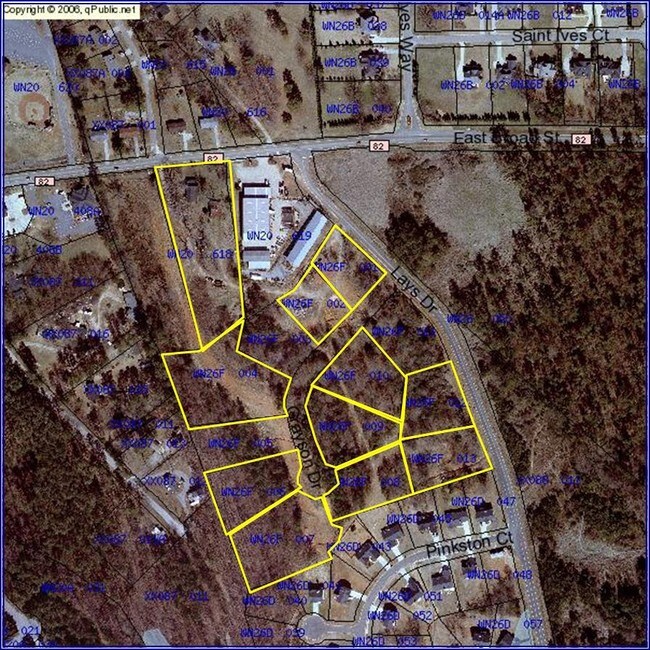
Property Record
414 Grayson Dr, Winder, GA 30680

Property Detail
414 Grayson Dr
Atlanta-Sandy Springs-Roswell, GA
LOT 10 PB 60-66 PINKSTON CORNERS
WN26F-010
BARROW
Commercialacreage
Georgia
B-2
10
B and X Area of moderate flood hazard, usually the area between the limits of the 100-year and 500-year floods.
1.06 AC
2025
Barrow County
2025
Atlanta
180203
NEARBY LISTINGS FOR SALE OR LEASE
DEMOGRAPHICS near 414 Grayson Dr
1 mile
3 mile
5 mile
2025 Total Population
6,913
26,541
47,430
2030 Population
7,853
29,977
53,713
Pop Growth 2025-2030
+ 13.60%
+ 12.95%
+ 13.25%
Average Age
39
38
38
2025 Total Households
2,527
9,532
16,673
HH Growth 2025-2030
+ 13.61%
+ 12.96%
+ 13.29%
Median Household Inc
$55,420
$57,729
$62,138
Avg Household Size
2.70
2.70
2.80
2025 Avg HH Vehicles
2.00
2.00
2.00
Median Home Value
$279,694
$272,426
$289,184
Median Year Built
2001
1996
2000
Nearby Places
Map Layers
Map Styles
 Street
 Aerial
Layers
 Traffic
 Biking
Places
Listings with unknown addresses are not visible on the map
- Restaurants
- Banks
- Shops
- Fitness
- Groceries
Nearby Properties
Address
Land Use
TOTAL SIZE
Lot Size
Zoning
Address
Land Use
TOTAL SIZE
Lot Size
Zoning
1,456 SF
1,732.81 AC
G
Address
Land Use
TOTAL SIZE
Lot Size
Zoning
105,850 SF
61 AC
G
Address
Land Use
TOTAL SIZE
Lot Size
Zoning
6,928 SF
358.89 AC
AC
Address
Land Use
TOTAL SIZE
Lot Size
Zoning
165,737 SF
9.70 AC
G
Address
Land Use
TOTAL SIZE
Lot Size
Zoning
50,000 SF
29 AC
G
Address
Land Use
TOTAL SIZE
Lot Size
Zoning
89,684 SF
64.92 AC
B-2
Address
Land Use
TOTAL SIZE
Lot Size
Zoning
20,132 SF
56.30 AC
M-2
Address
Land Use
TOTAL SIZE
Lot Size
Zoning
38,000 SF
362.35 AC
G,R-1A
Address
Land Use
TOTAL SIZE
Lot Size
Zoning
83,937 SF
17.83 AC
B-1
Address
Land Use
TOTAL SIZE
Lot Size
Zoning
35,790 SF
69.65 AC
G
Address
Land Use
TOTAL SIZE
Lot Size
Zoning
81,934 SF
30.94 AC
M-2
Address
Land Use
TOTAL SIZE
Lot Size
Zoning
6,960 SF
46.88 AC
M-2
Address
Land Use
TOTAL SIZE
Lot Size
Zoning
3,370 SF
352.38 AC
G,TNPD
Address
Land Use
TOTAL SIZE
Lot Size
Zoning
48,998 SF
15.53 AC
B-1
Address
Land Use
TOTAL SIZE
Lot Size
Zoning
3,462 SF
10.05 AC
G,R-3
Address
Land Use
TOTAL SIZE
Lot Size
Zoning
2,160 SF
23.93 AC
B-1
Address
Land Use
TOTAL SIZE
Lot Size
Zoning
4,210 SF
3.30 AC
G
Address
Land Use
TOTAL SIZE
Lot Size
Zoning
51,753 SF
9.15 AC
B-2,R-3
Address
Land Use
TOTAL SIZE
Lot Size
Zoning
4,405 SF
7.48 AC
B-1,R-1,R-
Address
Land Use
TOTAL SIZE
Lot Size
Zoning
20,592 SF
66.11 AC
G
Address
Land Use
TOTAL SIZE
Lot Size
Zoning
93,959 SF
14.28 AC
B-1
Address
Land Use
TOTAL SIZE
Lot Size
Zoning
30,575 SF
7.27 AC
G,R-1A
Address
Land Use
TOTAL SIZE
Lot Size
Zoning
50,662 SF
6.24 AC
G
Address
Land Use
TOTAL SIZE
Lot Size
Zoning
7,000 SF
10.73 AC
G
Address
Land Use
TOTAL SIZE
Lot Size
Zoning
3,116 SF
20.98 AC
G
Address
Land Use
TOTAL SIZE
Lot Size
Zoning
40,950 SF
32.90 AC
M-2
Address
Land Use
TOTAL SIZE
Lot Size
Zoning
11,914 SF
6.91 AC
G,R-2,R-3
Address
Land Use
TOTAL SIZE
Lot Size
Zoning
3,800 SF
4.49 AC
R-3
Address
Land Use
TOTAL SIZE
Lot Size
Zoning
105 SF
10.82 AC
R-3
Address
Land Use
TOTAL SIZE
Lot Size
Zoning
38,423 SF
4.11 AC
R-1
The World's #1 Commercial Real Estate Marketplace
Connect with us
© 2026 CoStar Group
The information above has been obtained from sources believed reliable. While we do not doubt its accuracy we have not verified it and make no guarantee, warranty or representation about it. It is your responsibility to independently confirm its accuracy and completeness. Any projections, opinions, assumptions, or estimates used are for example only and do not represent the current or future performance of the property. The value of this transaction to you depends on tax and other factors which should be evaluated by your tax, financial, and legal advisors. You and your advisors should conduct a careful, independent investigation of the property to determine to your satisfaction the suitability of the property for your needs.