Property Record
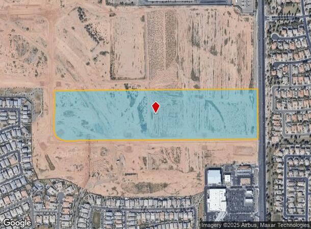
4140 S Signal Butte Rd, Mesa, AZ 85212
NEARBY LISTINGS FOR SALE OR LEASE
Property Detail
4140 S Signal Butte Rd
Phoenix
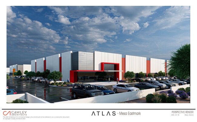
Eastmark Development Units 5 And 6
Phoenix-Mesa-Scottsdale, AZ
EASTMARK DEVELOPMENT UNITS 5 AND 6 MCR 1660-14
313-28-800
Maricopa
Commercialacreage
Arizona
2025
5
2025
38.39 AC
422647
Chandler N/Gilbert
DEMOGRAPHICS near 4140 S Signal Butte Rd
1 Mile
3 Mile
5 Mile
2024 Total Population
11,919
61,892
135,364
2029 Population
13,081
69,307
155,920
Pop Growth 2024-2029
+ 9.75%
+ 11.98%
+ 15.19%
Average Age
35
40
42
2024 Total Households
3,398
20,750
49,560
HH Growth 2024-2029
+ 9.98%
+ 12.46%
+ 16.23%
Median Household Inc
$144,807
$119,042
$92,548
Avg Household Size
3.40
2.90
2.70
2024 Avg HH Vehicles
2.00
2.00
2.00
Median Home Value
$632,462
$586,990
$444,044
Median Year Built
2010
2009
2003
Nearby Places
Map Layers
Map Styles
 Street
 Aerial
- Restaurants
- Banks
- Shops
- Fitness
- Groceries
PUBLIC TRANSPORTATION
AIRPORT
Phoenix-Mesa Gateway
DRIVE
WALK
Distance
Phoenix-Mesa Gateway
15 min
7.8 mi
Phoenix Sky Harbor International
DRIVE
WALK
Distance
Phoenix Sky Harbor International
43 min
30.9 mi
Freight Ports
Port of San Diego
DRIVE
WALK
Distance
Port of San Diego
422 min
382.0 mi
Nearby Properties
Address
Land Use
TOTAL SIZE
Lot Size
Zoning
Address
Land Use
TOTAL SIZE
Lot Size
Zoning
108,297 SF
102.46 AC
PS
Address
Land Use
TOTAL SIZE
Lot Size
Zoning
3,864 SF
67.50 AC
MH
Address
Land Use
TOTAL SIZE
Lot Size
Zoning
484,906 SF
199.48 AC
Address
Land Use
TOTAL SIZE
Lot Size
Zoning
1,195,173 SF
71.41 AC
Address
Land Use
TOTAL SIZE
Lot Size
Zoning
16.38 AC
Address
Land Use
TOTAL SIZE
Lot Size
Zoning
1,355,382 SF
83.17 AC
PAD
Address
Land Use
TOTAL SIZE
Lot Size
Zoning
467,727 SF
104.86 AC
AG
Address
Land Use
TOTAL SIZE
Lot Size
Zoning
454,704 SF
101.68 AC
AG
Address
Land Use
TOTAL SIZE
Lot Size
Zoning
15.78 AC
Address
Land Use
TOTAL SIZE
Lot Size
Zoning
18.36 AC
Address
Land Use
TOTAL SIZE
Lot Size
Zoning
12.99 AC
Address
Land Use
TOTAL SIZE
Lot Size
Zoning
449,435 SF
26.87 AC
LI
Address
Land Use
TOTAL SIZE
Lot Size
Zoning
779,546 SF
53.20 AC
LI
Address
Land Use
TOTAL SIZE
Lot Size
Zoning
965,386 SF
60.57 AC
Address
Land Use
TOTAL SIZE
Lot Size
Zoning
94,701 SF
7.89 AC
LC
Address
Land Use
TOTAL SIZE
Lot Size
Zoning
4.77 AC
LC
Address
Land Use
TOTAL SIZE
Lot Size
Zoning
14.77 AC
I-1
Address
Land Use
TOTAL SIZE
Lot Size
Zoning
281,929 SF
12.07 AC
Address
Land Use
TOTAL SIZE
Lot Size
Zoning
152,549 SF
60 AC
PC
Address
Land Use
TOTAL SIZE
Lot Size
Zoning
292,665 SF
15.26 AC
PC
Address
Land Use
TOTAL SIZE
Lot Size
Zoning
961,432 SF
63.41 AC
Address
Land Use
TOTAL SIZE
Lot Size
Zoning
4,000 SF
20 AC
CI2
Address
Land Use
TOTAL SIZE
Lot Size
Zoning
218,680 SF
8.50 AC
PC
Address
Land Use
TOTAL SIZE
Lot Size
Zoning
393,864 SF
41.21 AC
Address
Land Use
TOTAL SIZE
Lot Size
Zoning
3.88 AC
Address
Land Use
TOTAL SIZE
Lot Size
Zoning
95,886 SF
5.01 AC
Address
Land Use
TOTAL SIZE
Lot Size
Zoning
122,816 SF
12.40 AC
C-O
The World's #1 Commercial Real Estate Marketplace
Connect with us
© 2025 CoStar Group
The information above has been obtained from sources believed reliable. While we do not doubt its accuracy we have not verified it and make no guarantee, warranty or representation about it. It is your responsibility to independently confirm its accuracy and completeness. Any projections, opinions, assumptions, or estimates used are for example only and do not represent the current or future performance of the property. The value of this transaction to you depends on tax and other factors which should be evaluated by your tax, financial, and legal advisors. You and your advisors should conduct a careful, independent investigation of the property to determine to your satisfaction the suitability of the property for your needs.