Property Record
4141 Linglestown Rd, Harrisburg, PA 17112
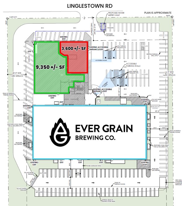

Current Lease Availabilities
NEARBY LISTINGS FOR SALE OR LEASE
Property Detail
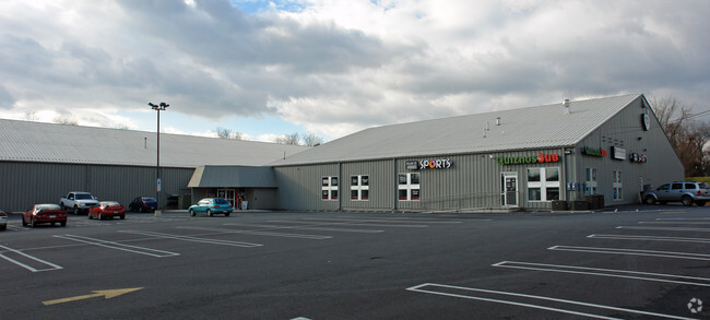
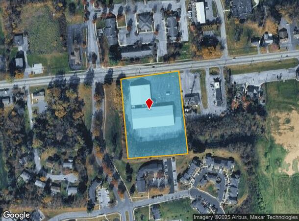
4141 Linglestown Rd
Skatingrink
Dauphin
X
Pennsylvania
42043C0330D
4 AC
2025
Harrisburg Area East
2025
Philadelphia
022401
Harrisburg-Carlisle, PA
45,824 SF
35-009-117
DEMOGRAPHICS near 4141 Linglestown Rd
1 Mile
3 Mile
5 Mile
2024 Total Population
7,913
45,219
113,438
2029 Population
8,242
46,281
116,073
Pop Growth 2024-2029
+ 4.16%
+ 2.35%
+ 2.32%
Average Age
44
42
41
2024 Total Households
3,026
18,705
46,252
HH Growth 2024-2029
+ 4.26%
+ 2.41%
+ 2.38%
Median Household Inc
$114,817
$83,472
$70,204
Avg Household Size
2.50
2.40
2.40
2024 Avg HH Vehicles
2.00
2.00
2.00
Median Home Value
$312,046
$236,465
$207,617
Median Year Built
1995
1982
1972
Nearby Places
Map Layers
Map Styles
 Street
 Aerial
- Restaurants
- Banks
- Shops
- Fitness
- Groceries
PUBLIC TRANSPORTATION
COMMUTER RAIL
Harrisburg (Keystone Service - Amtrak, Pennsylvanian - Amtrak)
DRIVE
WALK
Distance
Harrisburg (Keystone Service - Amtrak, Pennsylvanian - Amtrak)
16 min
8.4 mi
AIRPORT
Harrisburg International
DRIVE
WALK
Distance
Harrisburg International
23 min
13.7 mi
Freight Ports
Port of Baltimore
DRIVE
WALK
Distance
Port of Baltimore
123 min
88.0 mi
Nearby Properties
Address
Land Use
TOTAL SIZE
Lot Size
Zoning
Address
Land Use
TOTAL SIZE
Lot Size
Zoning
130,542 SF
28.94 AC
Address
Land Use
TOTAL SIZE
Lot Size
Zoning
192,390 SF
43.19 AC
Address
Land Use
TOTAL SIZE
Lot Size
Zoning
2,129 SF
19.90 AC
Address
Land Use
TOTAL SIZE
Lot Size
Zoning
112,388 SF
38.01 AC
Address
Land Use
TOTAL SIZE
Lot Size
Zoning
226,101 SF
46.29 AC
Address
Land Use
TOTAL SIZE
Lot Size
Zoning
82,881 SF
16.90 AC
Address
Land Use
TOTAL SIZE
Lot Size
Zoning
2,823 SF
36.87 AC
Address
Land Use
TOTAL SIZE
Lot Size
Zoning
1,989 SF
16.62 AC
Address
Land Use
TOTAL SIZE
Lot Size
Zoning
Address
Land Use
TOTAL SIZE
Lot Size
Zoning
9.88 AC
Address
Land Use
TOTAL SIZE
Lot Size
Zoning
246,276 SF
27.26 AC
Address
Land Use
TOTAL SIZE
Lot Size
Zoning
24.77 AC
Address
Land Use
TOTAL SIZE
Lot Size
Zoning
880 SF
18.68 AC
Address
Land Use
TOTAL SIZE
Lot Size
Zoning
1,920 SF
38.44 AC
Address
Land Use
TOTAL SIZE
Lot Size
Zoning
114,044 SF
23.13 AC
Address
Land Use
TOTAL SIZE
Lot Size
Zoning
29,125 SF
11.77 AC
Address
Land Use
TOTAL SIZE
Lot Size
Zoning
11,928 SF
8.40 AC
Address
Land Use
TOTAL SIZE
Lot Size
Zoning
66,864 SF
26.25 AC
Address
Land Use
TOTAL SIZE
Lot Size
Zoning
78,525 SF
15.50 AC
Address
Land Use
TOTAL SIZE
Lot Size
Zoning
64,329 SF
14.70 AC
Address
Land Use
TOTAL SIZE
Lot Size
Zoning
3,192 SF
17.32 AC
Address
Land Use
TOTAL SIZE
Lot Size
Zoning
78,519 SF
48.60 AC
Address
Land Use
TOTAL SIZE
Lot Size
Zoning
19,558 SF
12.50 AC
Address
Land Use
TOTAL SIZE
Lot Size
Zoning
371,502 SF
29.96 AC
Address
Land Use
TOTAL SIZE
Lot Size
Zoning
10,044 SF
12.94 AC
Address
Land Use
TOTAL SIZE
Lot Size
Zoning
8,230 SF
7.82 AC
Address
Land Use
TOTAL SIZE
Lot Size
Zoning
0.15 AC
Address
Land Use
TOTAL SIZE
Lot Size
Zoning
42,030 SF
10.29 AC
Address
Land Use
TOTAL SIZE
Lot Size
Zoning
54,630 SF
9.02 AC
Address
Land Use
TOTAL SIZE
Lot Size
Zoning
3,100 SF
24.70 AC
The World's #1 Commercial Real Estate Marketplace
Connect with us
© 2025 CoStar Group
The information above has been obtained from sources believed reliable. While we do not doubt its accuracy we have not verified it and make no guarantee, warranty or representation about it. It is your responsibility to independently confirm its accuracy and completeness. Any projections, opinions, assumptions, or estimates used are for example only and do not represent the current or future performance of the property. The value of this transaction to you depends on tax and other factors which should be evaluated by your tax, financial, and legal advisors. You and your advisors should conduct a careful, independent investigation of the property to determine to your satisfaction the suitability of the property for your needs.