No Photo
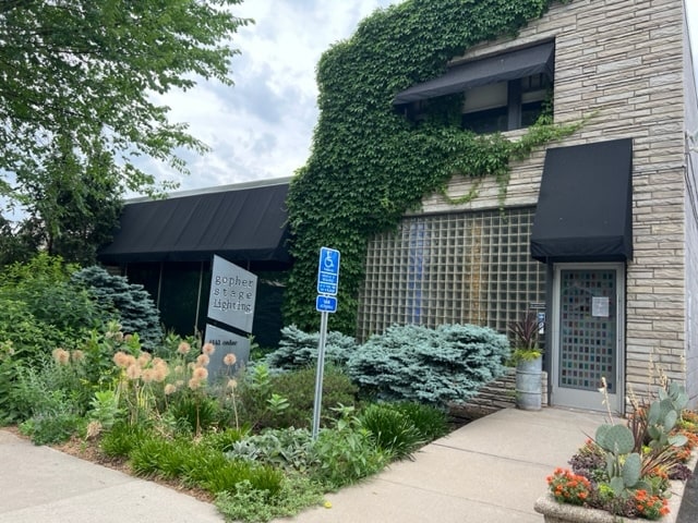
Property Record
4143 Cedar Ave S, Minneapolis, MN 55407
NEARBY LISTINGS FOR SALE OR LEASE
Property Detail
4143 Cedar Ave S
Minneapolis-St. Paul-Bloomington, MN-WI
Cedar Ave Heights 2Nd Addn To Mpls
12-028-24-23-0133
LOT 019 BLOCK 005 A CEDAR AVE HEIGHTS 2ND ADDN TO MPLS S 1/2 2436 SQ. FT.
Commercialacreage
Hennepin
X
Minnesota
27053C0386F
19
2024
0.06 AC
2024
Minneapolis
110100
Minneapolis/St Paul
DEMOGRAPHICS near 4143 Cedar Ave S
1 Mile
3 Mile
5 Mile
2024 Total Population
22,959
203,494
479,706
2029 Population
22,739
199,706
472,658
Pop Growth 2024-2029
(0.96%)
(1.86%)
(1.47%)
Average Age
39
38
38
2024 Total Households
9,600
87,881
215,304
HH Growth 2024-2029
(0.97%)
(1.95%)
(1.42%)
Median Household Inc
$87,026
$70,805
$73,553
Avg Household Size
2.30
2.20
2.10
2024 Avg HH Vehicles
2.00
1.00
1.00
Median Home Value
$299,601
$335,492
$362,777
Median Year Built
1946
1948
1956
Nearby Places
Map Layers
Map Styles
 Street
 Aerial
- Restaurants
- Banks
- Shops
- Fitness
- Groceries
PUBLIC TRANSPORTATION
COMMUTER RAIL
Target Field Station (Northstar Corridor - Northstar Commuter Rail)
DRIVE
WALK
Distance
Target Field Station (Northstar Corridor - Northstar Commuter Rail)
14 min
5.0 mi
AIRPORT
Minneapolis-St Paul International/Wold-Chamberlain
DRIVE
WALK
Distance
Minneapolis-St Paul International/Wold-Chamberlain
14 min
7.5 mi
Freight Ports
Port Milwaukee
DRIVE
WALK
Distance
Port Milwaukee
380 min
339.8 mi
SALE & LEASE HISTORY
LISTING DATE
SALE/LEASE

Jun 29, 2023
For Sale
Nearby Properties
Address
Land Use
TOTAL SIZE
Lot Size
Zoning
Address
Land Use
TOTAL SIZE
Lot Size
Zoning
141,277 SF
44.78 AC
Address
Land Use
TOTAL SIZE
Lot Size
Zoning
176,108 SF
27.45 AC
Address
Land Use
TOTAL SIZE
Lot Size
Zoning
458,470 SF
1.18 AC
OR3
Address
Land Use
TOTAL SIZE
Lot Size
Zoning
275,782 SF
2.40 AC
C3A
Address
Land Use
TOTAL SIZE
Lot Size
Zoning
2.65 AC
Address
Land Use
TOTAL SIZE
Lot Size
Zoning
386,583 SF
1.79 AC
OR2
Address
Land Use
TOTAL SIZE
Lot Size
Zoning
233,886 SF
1.63 AC
R5
Address
Land Use
TOTAL SIZE
Lot Size
Zoning
Address
Land Use
TOTAL SIZE
Lot Size
Zoning
295,036 SF
1.82 AC
R6
Address
Land Use
TOTAL SIZE
Lot Size
Zoning
346,787 SF
1.94 AC
R3
Address
Land Use
TOTAL SIZE
Lot Size
Zoning
186,691 SF
0.80 AC
C3A
Address
Land Use
TOTAL SIZE
Lot Size
Zoning
Address
Land Use
TOTAL SIZE
Lot Size
Zoning
354,346 SF
1.72 AC
R6
Address
Land Use
TOTAL SIZE
Lot Size
Zoning
160,202 SF
0.74 AC
C3A
Address
Land Use
TOTAL SIZE
Lot Size
Zoning
179,243 SF
1.05 AC
C2
Address
Land Use
TOTAL SIZE
Lot Size
Zoning
186,761 SF
1.14 AC
C3A
Address
Land Use
TOTAL SIZE
Lot Size
Zoning
283,912 SF
2.17 AC
R6
Address
Land Use
TOTAL SIZE
Lot Size
Zoning
307,923 SF
1.33 AC
R5
Address
Land Use
TOTAL SIZE
Lot Size
Zoning
184,111 SF
0.29 AC
C3A
Address
Land Use
TOTAL SIZE
Lot Size
Zoning
408,000 SF
0.97 AC
R6
Address
Land Use
TOTAL SIZE
Lot Size
Zoning
229,198 SF
1.39 AC
R3
Address
Land Use
TOTAL SIZE
Lot Size
Zoning
164,639 SF
0.96 AC
C3S
Address
Land Use
TOTAL SIZE
Lot Size
Zoning
219,788 SF
0.90 AC
C3A
Address
Land Use
TOTAL SIZE
Lot Size
Zoning
288,834 SF
1.72 AC
Address
Land Use
TOTAL SIZE
Lot Size
Zoning
263,928 SF
3.79 AC
R6
Address
Land Use
TOTAL SIZE
Lot Size
Zoning
2.18 AC
Address
Land Use
TOTAL SIZE
Lot Size
Zoning
89,000 SF
2.93 AC
R6
Address
Land Use
TOTAL SIZE
Lot Size
Zoning
263,928 SF
2.59 AC
R6
Address
Land Use
TOTAL SIZE
Lot Size
Zoning
Address
Land Use
TOTAL SIZE
Lot Size
Zoning
254,517 SF
2.22 AC
C3A
The World's #1 Commercial Real Estate Marketplace
Connect with us
© 2025 CoStar Group
The information above has been obtained from sources believed reliable. While we do not doubt its accuracy we have not verified it and make no guarantee, warranty or representation about it. It is your responsibility to independently confirm its accuracy and completeness. Any projections, opinions, assumptions, or estimates used are for example only and do not represent the current or future performance of the property. The value of this transaction to you depends on tax and other factors which should be evaluated by your tax, financial, and legal advisors. You and your advisors should conduct a careful, independent investigation of the property to determine to your satisfaction the suitability of the property for your needs.