Property Record
4142 S Loop 1604 E, San Antonio, TX 78264
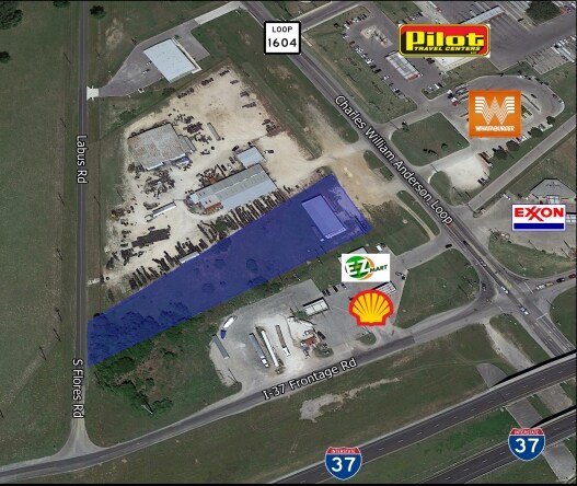


Property Detail
4142 S Loop 1604 E
San Antonio-New Braunfels, TX
NCB 16628 (QT 4058) BLK 7 LOT 1 2021-NEW PER PLAT 20001/2080 FILED 2-21-2020. CR-49631. JLF/GIS/6-16-2020
16628-007-0010
BEXAR
Servicestation
Texas
B and X Area of moderate flood hazard, usually the area between the limits of the 100-year and 500-year floods.
172
2024
4.53 AC
2025
South
152201
San Antonio
47,314 SF
NEARBY LISTINGS FOR SALE OR LEASE
-
-
View all San Antonio listings for sale on LoopNet.com
DEMOGRAPHICS near 4142 S Loop 1604 E
1 mile
3 mile
5 mile
2025 Total Population
853
9,144
22,106
2030 Population
912
9,773
23,905
Pop Growth 2025-2030
+ 6.92%
+ 6.88%
+ 8.14%
Average Age
36
36
37
2025 Total Households
268
2,733
6,680
HH Growth 2025-2030
+ 7.09%
+ 6.99%
+ 8.23%
Median Household Inc
$67,763
$53,187
$59,353
Avg Household Size
3.10
3.30
3.20
2025 Avg HH Vehicles
2.00
2.00
2.00
Median Home Value
$141,489
$161,789
$171,711
Median Year Built
2003
1998
1999
Nearby Places
Map Layers
Map Styles
 Street
 Aerial
Transit
 Traffic
 Biking
Places
Listings with unknown addresses are not visible on the map
- Restaurants
- Banks
- Shops
- Fitness
- Groceries
PUBLIC TRANSPORTATION
AIRPORT
San Antonio International
Drive
Walk
Distance
San Antonio International
29 min
24.4 mi
Freight Ports
Port of Corpus Christi
Drive
Walk
Distance
Port of Corpus Christi
128 min
126.4 mi
SALE & LEASE HISTORY
LISTING DATE
SALE/LEASE

Dec 02, 2016
For Sale
Nearby Properties
Address
Land Use
TOTAL SIZE
Lot Size
Zoning
Address
Land Use
TOTAL SIZE
Lot Size
Zoning
226,474 SF
108.81 AC
Address
Land Use
TOTAL SIZE
Lot Size
Zoning
211,505 SF
21.04 AC
Address
Land Use
TOTAL SIZE
Lot Size
Zoning
2,451,718 SF
148.17 AC
Address
Land Use
TOTAL SIZE
Lot Size
Zoning
57,863 SF
36.23 AC
Address
Land Use
TOTAL SIZE
Lot Size
Zoning
5,753,521 SF
709.61 AC
Address
Land Use
TOTAL SIZE
Lot Size
Zoning
300.90 AC
Address
Land Use
TOTAL SIZE
Lot Size
Zoning
1,890 SF
361.85 AC
Address
Land Use
TOTAL SIZE
Lot Size
Zoning
485.17 AC
Address
Land Use
TOTAL SIZE
Lot Size
Zoning
298.72 AC
Address
Land Use
TOTAL SIZE
Lot Size
Zoning
116,731 SF
9.22 AC
Address
Land Use
TOTAL SIZE
Lot Size
Zoning
1,056 SF
304.42 AC
Address
Land Use
TOTAL SIZE
Lot Size
Zoning
153.39 AC
Address
Land Use
TOTAL SIZE
Lot Size
Zoning
43,005 SF
2.48 AC
Address
Land Use
TOTAL SIZE
Lot Size
Zoning
9,673,474 SF
8.35 AC
Address
Land Use
TOTAL SIZE
Lot Size
Zoning
19,623 SF
21.04 AC
Address
Land Use
TOTAL SIZE
Lot Size
Zoning
17,500 SF
6.77 AC
Address
Land Use
TOTAL SIZE
Lot Size
Zoning
29,105 SF
2.16 AC
Address
Land Use
TOTAL SIZE
Lot Size
Zoning
16,710 SF
4 AC
Address
Land Use
TOTAL SIZE
Lot Size
Zoning
420 SF
150 AC
Address
Land Use
TOTAL SIZE
Lot Size
Zoning
346,206 SF
2.99 AC
Address
Land Use
TOTAL SIZE
Lot Size
Zoning
21,562 SF
6.88 AC
Address
Land Use
TOTAL SIZE
Lot Size
Zoning
185.13 AC
Address
Land Use
TOTAL SIZE
Lot Size
Zoning
181.82 AC
Address
Land Use
TOTAL SIZE
Lot Size
Zoning
3,672 SF
2.16 AC
Address
Land Use
TOTAL SIZE
Lot Size
Zoning
222.49 AC
Address
Land Use
TOTAL SIZE
Lot Size
Zoning
3,183 SF
2.23 AC
Address
Land Use
TOTAL SIZE
Lot Size
Zoning
56,200 SF
2.90 AC
Address
Land Use
TOTAL SIZE
Lot Size
Zoning
784 SF
20.19 AC
Address
Land Use
TOTAL SIZE
Lot Size
Zoning
162.53 AC
The World's #1 Commercial Real Estate Marketplace
Connect with us
© 2026 CoStar Group
The information above has been obtained from sources believed reliable. While we do not doubt its accuracy we have not verified it and make no guarantee, warranty or representation about it. It is your responsibility to independently confirm its accuracy and completeness. Any projections, opinions, assumptions, or estimates used are for example only and do not represent the current or future performance of the property. The value of this transaction to you depends on tax and other factors which should be evaluated by your tax, financial, and legal advisors. You and your advisors should conduct a careful, independent investigation of the property to determine to your satisfaction the suitability of the property for your needs.