Property Record
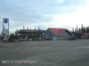
41437 Sterling Hwy, Soldotna, AK 99669


NEARBY LISTINGS FOR SALE OR LEASE
-
-
View all Soldotna listings for sale on LoopNet.com
Property Detail
41437 Sterling Hwy
Other Market Areas
Mcsmith Sub Isham Addn
058-340-89
T 5N R 10W SEC 26 SEWARD MERIDIAN KN 2007080 MCSMITH SUB ISHAM ADDN LOT 2
Commercialnec
Kenai Peninsula
2024
Alaska
2025
2
000800
2.49 AC
2,687 SF
Alaska Regional
DEMOGRAPHICS near 41437 Sterling Hwy
1 Mile
3 Mile
5 Mile
2024 Total Population
594
4,134
12,684
2029 Population
625
4,419
13,843
Pop Growth 2024-2029
+ 5.22%
+ 6.89%
+ 9.14%
Average Age
44
44
42
2024 Total Households
250
1,753
5,299
HH Growth 2024-2029
+ 5.20%
+ 6.79%
+ 9.02%
Median Household Inc
$105,092
$90,740
$74,275
Avg Household Size
2.30
2.30
2.30
2024 Avg HH Vehicles
2.00
2.00
2.00
Median Home Value
$365,789
$361,137
$299,368
Median Year Built
1990
1991
1991
Nearby Places
Map Layers
Map Styles
 Street
 Aerial
- Restaurants
- Banks
- Shops
- Fitness
- Groceries
PUBLIC TRANSPORTATION
AIRPORT
Kenai Municipal
DRIVE
WALK
Distance
Kenai Municipal
33 min
15.9 mi
Nearby Properties
Address
Land Use
TOTAL SIZE
Lot Size
Zoning
Address
Land Use
TOTAL SIZE
Lot Size
Zoning
163,358 SF
17.75 AC
Address
Land Use
TOTAL SIZE
Lot Size
Zoning
31,389 SF
7.44 AC
Address
Land Use
TOTAL SIZE
Lot Size
Zoning
31,146 SF
1.21 AC
Address
Land Use
TOTAL SIZE
Lot Size
Zoning
30,311 SF
Address
Land Use
TOTAL SIZE
Lot Size
Zoning
3,364 SF
21.14 AC
Address
Land Use
TOTAL SIZE
Lot Size
Zoning
7,164 SF
8.11 AC
Address
Land Use
TOTAL SIZE
Lot Size
Zoning
8,922 SF
1.38 AC
Address
Land Use
TOTAL SIZE
Lot Size
Zoning
12,460 SF
52.33 AC
Address
Land Use
TOTAL SIZE
Lot Size
Zoning
17,261 SF
0.86 AC
Address
Land Use
TOTAL SIZE
Lot Size
Zoning
31,924 SF
62.41 AC
Address
Land Use
TOTAL SIZE
Lot Size
Zoning
5,528 SF
33 AC
Address
Land Use
TOTAL SIZE
Lot Size
Zoning
11,091 SF
5.46 AC
Address
Land Use
TOTAL SIZE
Lot Size
Zoning
268.05 AC
Address
Land Use
TOTAL SIZE
Lot Size
Zoning
10,760 SF
0.92 AC
Address
Land Use
TOTAL SIZE
Lot Size
Zoning
40,675 SF
2.01 AC
Address
Land Use
TOTAL SIZE
Lot Size
Zoning
12,394 SF
2.14 AC
Address
Land Use
TOTAL SIZE
Lot Size
Zoning
10,216 SF
4.47 AC
Address
Land Use
TOTAL SIZE
Lot Size
Zoning
6,998 SF
0.90 AC
Address
Land Use
TOTAL SIZE
Lot Size
Zoning
8,770 SF
0.96 AC
Address
Land Use
TOTAL SIZE
Lot Size
Zoning
9,035 SF
1.79 AC
Address
Land Use
TOTAL SIZE
Lot Size
Zoning
10,664 SF
4.43 AC
Address
Land Use
TOTAL SIZE
Lot Size
Zoning
7,154 SF
3.62 AC
Address
Land Use
TOTAL SIZE
Lot Size
Zoning
6,268 SF
0.94 AC
Address
Land Use
TOTAL SIZE
Lot Size
Zoning
17,655 SF
2.93 AC
Address
Land Use
TOTAL SIZE
Lot Size
Zoning
7,679 SF
1.19 AC
Address
Land Use
TOTAL SIZE
Lot Size
Zoning
5,296 SF
50.27 AC
Address
Land Use
TOTAL SIZE
Lot Size
Zoning
3,403 SF
1.51 AC
Address
Land Use
TOTAL SIZE
Lot Size
Zoning
644 SF
5.76 AC
Address
Land Use
TOTAL SIZE
Lot Size
Zoning
9,645 SF
0.92 AC
Address
Land Use
TOTAL SIZE
Lot Size
Zoning
11,812 SF
114.70 AC
The World's #1 Commercial Real Estate Marketplace
Connect with us
© 2026 CoStar Group
The information above has been obtained from sources believed reliable. While we do not doubt its accuracy we have not verified it and make no guarantee, warranty or representation about it. It is your responsibility to independently confirm its accuracy and completeness. Any projections, opinions, assumptions, or estimates used are for example only and do not represent the current or future performance of the property. The value of this transaction to you depends on tax and other factors which should be evaluated by your tax, financial, and legal advisors. You and your advisors should conduct a careful, independent investigation of the property to determine to your satisfaction the suitability of the property for your needs.