Property Record
4145 Day Rd Nw, Conyers, GA 30012
NEARBY LISTINGS FOR SALE OR LEASE
Property Detail
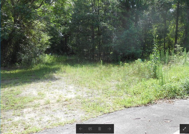
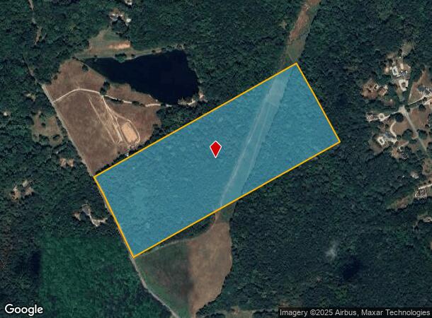
4145 Day Rd Nw
Atlanta-Sandy Springs-Roswell, GA
Rural
052-0-01-018A
DAY RD
Agriculturalland
Rockdale
A
Georgia
13247C0040D
40.59 AC
2024
I-20 East/Conyers
2024
Atlanta
060101
DEMOGRAPHICS near 4145 Day Rd Nw
1 Mile
3 Mile
5 Mile
2024 Total Population
1,064
19,995
66,058
2029 Population
1,111
20,850
68,891
Pop Growth 2024-2029
+ 4.42%
+ 4.28%
+ 4.29%
Average Age
41
38
38
2024 Total Households
357
6,516
21,566
HH Growth 2024-2029
+ 4.48%
+ 4.37%
+ 4.34%
Median Household Inc
$65,131
$77,983
$78,568
Avg Household Size
2.90
3.00
3.00
2024 Avg HH Vehicles
2.00
2.00
2.00
Median Home Value
$255,405
$240,000
$248,114
Median Year Built
1989
1998
1995
Nearby Places
Map Layers
Map Styles
 Street
 Aerial
- Restaurants
- Banks
- Shops
- Fitness
- Groceries
PUBLIC TRANSPORTATION
AIRPORT
Hartsfield - Jackson Atlanta International
DRIVE
WALK
Distance
Hartsfield - Jackson Atlanta International
48 min
31.6 mi
Freight Ports
Georgia Ports - Savannah
DRIVE
WALK
Distance
Georgia Ports - Savannah
292 min
248.5 mi
SALE & LEASE HISTORY
LISTING DATE
SALE/LEASE

Oct 12, 2018
For Sale
Nearby Properties
Address
Land Use
TOTAL SIZE
Lot Size
Zoning
Address
Land Use
TOTAL SIZE
Lot Size
Zoning
23,692 SF
112.46 AC
RA200
Address
Land Use
TOTAL SIZE
Lot Size
Zoning
350.63 AC
R100
Address
Land Use
TOTAL SIZE
Lot Size
Zoning
1,296 SF
65.93 AC
R100
Address
Land Use
TOTAL SIZE
Lot Size
Zoning
36.74 AC
R100
Address
Land Use
TOTAL SIZE
Lot Size
Zoning
20,812 SF
16.29 AC
R100
Address
Land Use
TOTAL SIZE
Lot Size
Zoning
653.65 AC
WP
Address
Land Use
TOTAL SIZE
Lot Size
Zoning
2,400 SF
10.77 AC
R100
Address
Land Use
TOTAL SIZE
Lot Size
Zoning
46,452 SF
20 AC
AR
Address
Land Use
TOTAL SIZE
Lot Size
Zoning
6,000 SF
2 AC
C1
Address
Land Use
TOTAL SIZE
Lot Size
Zoning
8,052 SF
9.44 AC
R100
Address
Land Use
TOTAL SIZE
Lot Size
Zoning
9,504 SF
0.81 AC
C1
Address
Land Use
TOTAL SIZE
Lot Size
Zoning
9,869 SF
3.20 AC
C1/C
Address
Land Use
TOTAL SIZE
Lot Size
Zoning
84.52 AC
RSM
Address
Land Use
TOTAL SIZE
Lot Size
Zoning
5,500 SF
2.11 AC
C1
Address
Land Use
TOTAL SIZE
Lot Size
Zoning
9,000 SF
21 AC
AR/WP
Address
Land Use
TOTAL SIZE
Lot Size
Zoning
7,988 SF
0.94 AC
C1
Address
Land Use
TOTAL SIZE
Lot Size
Zoning
4,822 SF
15.17 AC
WP
Address
Land Use
TOTAL SIZE
Lot Size
Zoning
5,406 SF
2.07 AC
C1
Address
Land Use
TOTAL SIZE
Lot Size
Zoning
4,310 SF
7.79 AC
AR
Address
Land Use
TOTAL SIZE
Lot Size
Zoning
2,480 SF
0.75 AC
WP/NCU
Address
Land Use
TOTAL SIZE
Lot Size
Zoning
120.71 AC
WP
Address
Land Use
TOTAL SIZE
Lot Size
Zoning
6,900 SF
4.02 AC
R100
Address
Land Use
TOTAL SIZE
Lot Size
Zoning
5,837 SF
15 AC
AR
Address
Land Use
TOTAL SIZE
Lot Size
Zoning
3,151 SF
1.47 AC
C1
Address
Land Use
TOTAL SIZE
Lot Size
Zoning
200 SF
28.27 AC
WP
Address
Land Use
TOTAL SIZE
Lot Size
Zoning
2,400 SF
1.16 AC
C1
Address
Land Use
TOTAL SIZE
Lot Size
Zoning
4,052 SF
2 AC
AR
Address
Land Use
TOTAL SIZE
Lot Size
Zoning
93.39 AC
WP
Address
Land Use
TOTAL SIZE
Lot Size
Zoning
1,312 SF
131.11 AC
WP
Address
Land Use
TOTAL SIZE
Lot Size
Zoning
92.46 AC
WP
The World's #1 Commercial Real Estate Marketplace
Connect with us
© 2025 CoStar Group
The information above has been obtained from sources believed reliable. While we do not doubt its accuracy we have not verified it and make no guarantee, warranty or representation about it. It is your responsibility to independently confirm its accuracy and completeness. Any projections, opinions, assumptions, or estimates used are for example only and do not represent the current or future performance of the property. The value of this transaction to you depends on tax and other factors which should be evaluated by your tax, financial, and legal advisors. You and your advisors should conduct a careful, independent investigation of the property to determine to your satisfaction the suitability of the property for your needs.