Property Record
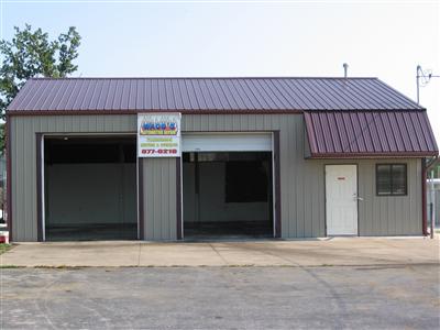
4148 W 3Rd St, Battlefield, MO 65619

Property Detail
4148 W 3Rd St
18-20-300-481
COWBOY CORNER W 66 FT LOT 2 (EX S 162.06 FT)
Autorepair
Greene
INC
Missouri
B and X Area of moderate flood hazard, usually the area between the limits of the 100-year and 500-year floods.
2
2025
0.21 AC
2025
Southwest
004104
Springfield
1,200 SF
Springfield, MO
NEARBY LISTINGS FOR SALE OR LEASE
-
-
View all Battlefield listings for sale on LoopNet.com
DEMOGRAPHICS near 4148 W 3Rd St
1 mile
3 mile
5 mile
2025 Total Population
5,531
27,885
79,777
2030 Population
5,662
28,509
81,676
Pop Growth 2025-2030
+ 2.37%
+ 2.24%
+ 2.38%
Average Age
40
40
40
2025 Total Households
2,079
11,004
33,056
HH Growth 2025-2030
+ 2.41%
+ 2.31%
+ 2.36%
Median Household Inc
$97,689
$80,343
$70,003
Avg Household Size
2.60
2.50
2.30
2025 Avg HH Vehicles
2.00
2.00
2.00
Median Home Value
$273,194
$281,252
$262,325
Median Year Built
2001
1996
1994
Nearby Places
Map Layers
Map Styles
 Street
 Aerial
Transit
 Traffic
 Biking
Places
Listings with unknown addresses are not visible on the map
- Restaurants
- Banks
- Shops
- Fitness
- Groceries
PUBLIC TRANSPORTATION
AIRPORT
Springfield-Branson Ntl
Drive
Walk
Distance
Springfield-Branson Ntl
27 min
13.0 mi
Nearby Properties
Address
Land Use
TOTAL SIZE
Lot Size
Zoning
Address
Land Use
TOTAL SIZE
Lot Size
Zoning
Address
Land Use
TOTAL SIZE
Lot Size
Zoning
6.24 AC
INC
Address
Land Use
TOTAL SIZE
Lot Size
Zoning
8.26 AC
INC
Address
Land Use
TOTAL SIZE
Lot Size
Zoning
Address
Land Use
TOTAL SIZE
Lot Size
Zoning
126,242 SF
4.75 AC
INC
Address
Land Use
TOTAL SIZE
Lot Size
Zoning
85,030 SF
8.89 AC
INC
Address
Land Use
TOTAL SIZE
Lot Size
Zoning
128,448 SF
4.30 AC
INC
Address
Land Use
TOTAL SIZE
Lot Size
Zoning
5.63 AC
INC
Address
Land Use
TOTAL SIZE
Lot Size
Zoning
6.65 AC
INC
Address
Land Use
TOTAL SIZE
Lot Size
Zoning
132,065 SF
8 AC
INC
Address
Land Use
TOTAL SIZE
Lot Size
Zoning
Address
Land Use
TOTAL SIZE
Lot Size
Zoning
94,344 SF
3.54 AC
INC
Address
Land Use
TOTAL SIZE
Lot Size
Zoning
50,250 SF
4.01 AC
INC
Address
Land Use
TOTAL SIZE
Lot Size
Zoning
80,133 SF
3.16 AC
INC
Address
Land Use
TOTAL SIZE
Lot Size
Zoning
1.93 AC
INC
Address
Land Use
TOTAL SIZE
Lot Size
Zoning
3.87 AC
INC
Address
Land Use
TOTAL SIZE
Lot Size
Zoning
79,495 SF
4.78 AC
INC
Address
Land Use
TOTAL SIZE
Lot Size
Zoning
7,946 SF
1.90 AC
INC.
Address
Land Use
TOTAL SIZE
Lot Size
Zoning
9.02 AC
R-1;INC
Address
Land Use
TOTAL SIZE
Lot Size
Zoning
1.88 AC
INC
Address
Land Use
TOTAL SIZE
Lot Size
Zoning
2.34 AC
INC
Address
Land Use
TOTAL SIZE
Lot Size
Zoning
3.09 AC
INC
Address
Land Use
TOTAL SIZE
Lot Size
Zoning
6,626 SF
2.26 AC
INC
Address
Land Use
TOTAL SIZE
Lot Size
Zoning
14,000 SF
1.34 AC
INC
Address
Land Use
TOTAL SIZE
Lot Size
Zoning
20,142 SF
2.23 AC
INC
Address
Land Use
TOTAL SIZE
Lot Size
Zoning
13,856 SF
1.74 AC
INC
Address
Land Use
TOTAL SIZE
Lot Size
Zoning
56,065 SF
3.76 AC
C-2
Address
Land Use
TOTAL SIZE
Lot Size
Zoning
18,000 SF
5.02 AC
C-2
Address
Land Use
TOTAL SIZE
Lot Size
Zoning
49,596 SF
4.22 AC
R-3
Address
Land Use
TOTAL SIZE
Lot Size
Zoning
1,336 SF
2.07 AC
C-2
The World's #1 Commercial Real Estate Marketplace
Connect with us
© 2026 CoStar Group
The information above has been obtained from sources believed reliable. While we do not doubt its accuracy we have not verified it and make no guarantee, warranty or representation about it. It is your responsibility to independently confirm its accuracy and completeness. Any projections, opinions, assumptions, or estimates used are for example only and do not represent the current or future performance of the property. The value of this transaction to you depends on tax and other factors which should be evaluated by your tax, financial, and legal advisors. You and your advisors should conduct a careful, independent investigation of the property to determine to your satisfaction the suitability of the property for your needs.