Property Record
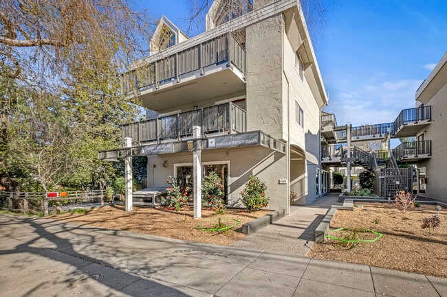
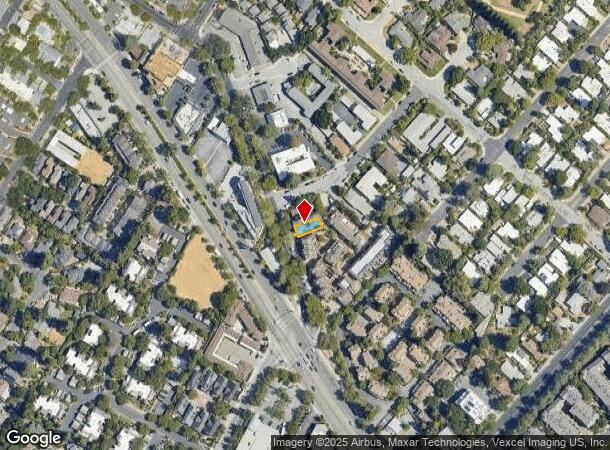
4149 El Camino Way, Palo Alto, CA 94306

This Property Is For Sale
NEARBY LISTINGS FOR SALE OR LEASE
Property Detail
4149 El Camino Way
San Jose-Sunnyvale-Santa Clara, CA
Hamlet Condo
132-60-030
Santa Clara
Condominium
California
X
0.03 AC
06085C0036H
Palo Alto
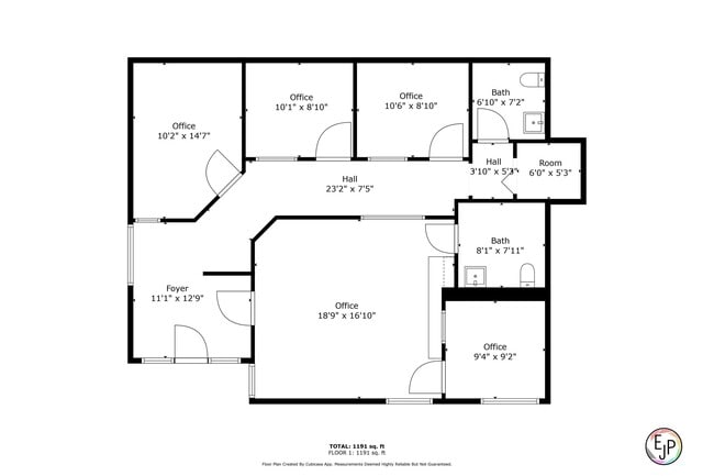
1,119 SF
South Bay/San Jose
DEMOGRAPHICS near 4149 El Camino Way
1 Mile
3 Mile
5 Mile
2024 Total Population
26,128
146,946
293,763
2029 Population
25,553
143,189
284,756
Pop Growth 2024-2029
(2.20%)
(2.56%)
(3.07%)
Average Age
41
39
39
2024 Total Households
10,309
54,997
107,556
HH Growth 2024-2029
(2.23%)
(2.52%)
(3.06%)
Median Household Inc
$197,317
$177,079
$177,598
Avg Household Size
2.50
2.40
2.50
2024 Avg HH Vehicles
2.00
2.00
2.00
Median Home Value
$1,141,674
$1,139,062
$1,134,784
Median Year Built
1968
1970
1969
Nearby Places
- Restaurants
- Banks
- Shops
- Fitness
- Groceries
PUBLIC TRANSPORTATION
COMMUTER RAIL
San Antonio (Caltrain - Caltrain (Caltrain), Limited - Caltrain (Caltrain), Local Weekday - Caltrain (Caltrain), Local Weekend - Caltrain (Caltrain))
DRIVE
WALK
Distance
San Antonio (Caltrain - Caltrain (Caltrain), Limited - Caltrain (Caltrain), Local Weekday - Caltrain (Caltrain), Local Weekend - Caltrain (Caltrain))
4 min
1.7 mi
California Avenue (Caltrain - Caltrain (Caltrain))
DRIVE
WALK
Distance
California Avenue (Caltrain - Caltrain (Caltrain))
5 min
2.0 mi
AIRPORT
Norman Y Mineta San Jose International
DRIVE
WALK
Distance
Norman Y Mineta San Jose International
20 min
12.5 mi
San Francisco International
DRIVE
WALK
Distance
San Francisco International
34 min
23.8 mi
Metro Oakland International
DRIVE
WALK
Distance
Metro Oakland International
47 min
32.5 mi
Freight Ports
Port of Redwood City
DRIVE
WALK
Distance
Port of Redwood City
19 min
10.6 mi
Nearby Properties
Address
Land Use
TOTAL SIZE
Lot Size
Zoning
Address
Land Use
TOTAL SIZE
Lot Size
Zoning
42.28 AC
PF
Address
Land Use
TOTAL SIZE
Lot Size
Zoning
499,360 SF
31.95 AC
MM40
Address
Land Use
TOTAL SIZE
Lot Size
Zoning
0.33 AC
PF
Address
Land Use
TOTAL SIZE
Lot Size
Zoning
450,575 SF
3.73 AC
P(9)
Address
Land Use
TOTAL SIZE
Lot Size
Zoning
355,490 SF
26.49 AC
P39
Address
Land Use
TOTAL SIZE
Lot Size
Zoning
440,173 SF
25.33 AC
P39
Address
Land Use
TOTAL SIZE
Lot Size
Zoning
78,277 SF
16.31 AC
RP
Address
Land Use
TOTAL SIZE
Lot Size
Zoning
265,341 SF
13.53 AC
RP
Address
Land Use
TOTAL SIZE
Lot Size
Zoning
584,389 SF
5.25 AC
P(40)
Address
Land Use
TOTAL SIZE
Lot Size
Zoning
595,000 SF
7.42 AC
P(34)
Address
Land Use
TOTAL SIZE
Lot Size
Zoning
675,100 SF
52.78 AC
RP5
Address
Land Use
TOTAL SIZE
Lot Size
Zoning
233,124 SF
9.18 AC
P(7)
Address
Land Use
TOTAL SIZE
Lot Size
Zoning
4.13 AC
P39
Address
Land Use
TOTAL SIZE
Lot Size
Zoning
458,842 SF
26.64 AC
RP5
Address
Land Use
TOTAL SIZE
Lot Size
Zoning
372,859 SF
4.71 AC
P
Address
Land Use
TOTAL SIZE
Lot Size
Zoning
298,463 SF
7 AC
P(19)
Address
Land Use
TOTAL SIZE
Lot Size
Zoning
640,105 SF
7.90 AC
R3-2*
Address
Land Use
TOTAL SIZE
Lot Size
Zoning
521,754 SF
46.72 AC
RP
Address
Land Use
TOTAL SIZE
Lot Size
Zoning
224,505 SF
5.15 AC
CORE
Address
Land Use
TOTAL SIZE
Lot Size
Zoning
322,264 SF
3.92 AC
P
Address
Land Use
TOTAL SIZE
Lot Size
Zoning
20,140.41 AC
MV
Address
Land Use
TOTAL SIZE
Lot Size
Zoning
208.82 AC
MV
Address
Land Use
TOTAL SIZE
Lot Size
Zoning
110,384 SF
10.17 AC
RP
Address
Land Use
TOTAL SIZE
Lot Size
Zoning
89,237 SF
5.51 AC
P(9)
Address
Land Use
TOTAL SIZE
Lot Size
Zoning
652,964 SF
14.99 AC
GM
Address
Land Use
TOTAL SIZE
Lot Size
Zoning
516,963 SF
36.46 AC
RP
Address
Land Use
TOTAL SIZE
Lot Size
Zoning
224,086 SF
10.80 AC
R3-1.
Address
Land Use
TOTAL SIZE
Lot Size
Zoning
2.90 AC
P(17)
Address
Land Use
TOTAL SIZE
Lot Size
Zoning
113,964 SF
6.28 AC
RP
Address
Land Use
TOTAL SIZE
Lot Size
Zoning
276,538 SF
2.19 AC
ML
The World's #1 Commercial Real Estate Marketplace
Connect with us
© 2025 CoStar Group
The information above has been obtained from sources believed reliable. While we do not doubt its accuracy we have not verified it and make no guarantee, warranty or representation about it. It is your responsibility to independently confirm its accuracy and completeness. Any projections, opinions, assumptions, or estimates used are for example only and do not represent the current or future performance of the property. The value of this transaction to you depends on tax and other factors which should be evaluated by your tax, financial, and legal advisors. You and your advisors should conduct a careful, independent investigation of the property to determine to your satisfaction the suitability of the property for your needs.