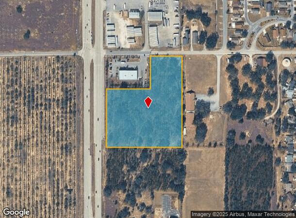
Property Record
41491 Highway 27, Davenport, FL 33837
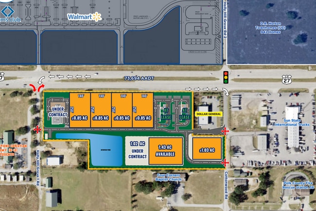
Current Lease Availabilities
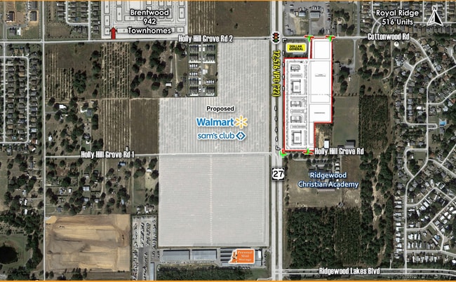
NEARBY LISTINGS FOR SALE OR LEASE
Property Detail
41491 Highway 27
Lakeland-Winter Haven, FL
Florida Development Co Subdivision
27-26-29-706500-030010
FLA DEVELOPMENT CO SUB PB 3 PG 60 TO 63 TRACTS 1 2 IN NW1/4 LESS RW FOR HWY 27 & LESS THAT PART BEING R/W PCL 100 FOR FLASHING BEACON & EMERGENCY SIGNAL AT US 27 & COTTONWOOD DR AS DESC IN OR 8659 PG 0732 & 8734 PG 2156 & LESS COMM NE COR OF TRACT 2
Commercialacreage
Polk
X
Florida
12105C0225G
1
2024
6.34 AC
2025
Polk County
012508
Tampa/St Petersburg
DEMOGRAPHICS near 41491 Highway 27
1 Mile
3 Mile
5 Mile
2024 Total Population
7,265
29,191
88,339
2029 Population
9,060
36,529
110,432
Pop Growth 2024-2029
+ 24.71%
+ 25.14%
+ 25.01%
Average Age
40
42
39
2024 Total Households
2,610
10,841
32,018
HH Growth 2024-2029
+ 24.71%
+ 25.11%
+ 25.00%
Median Household Inc
$58,348
$63,128
$64,496
Avg Household Size
2.80
2.70
2.70
2024 Avg HH Vehicles
2.00
2.00
2.00
Median Home Value
$210,092
$234,640
$256,207
Median Year Built
2006
2009
2009
Nearby Places
- Restaurants
- Banks
- Shops
- Fitness
- Groceries
PUBLIC TRANSPORTATION
AIRPORT
Orlando International
DRIVE
WALK
Distance
Orlando International
41 min
31.1 mi
Freight Ports
Port of Tampa Bay
DRIVE
WALK
Distance
Port of Tampa Bay
71 min
59.3 mi
Nearby Properties
Address
Land Use
TOTAL SIZE
Lot Size
Zoning
Address
Land Use
TOTAL SIZE
Lot Size
Zoning
1,125,150 SF
51.12 AC
RC
Address
Land Use
TOTAL SIZE
Lot Size
Zoning
969,150 SF
91.98 AC
RC
Address
Land Use
TOTAL SIZE
Lot Size
Zoning
403,448 SF
14.96 AC
Address
Land Use
TOTAL SIZE
Lot Size
Zoning
372,655 SF
17.06 AC
C5
Address
Land Use
TOTAL SIZE
Lot Size
Zoning
306,788 SF
13.35 AC
XX
Address
Land Use
TOTAL SIZE
Lot Size
Zoning
308,973 SF
18.38 AC
Address
Land Use
TOTAL SIZE
Lot Size
Zoning
310,669 SF
36.01 AC
RC
Address
Land Use
TOTAL SIZE
Lot Size
Zoning
328,817 SF
12.62 AC
Address
Land Use
TOTAL SIZE
Lot Size
Zoning
491,027 SF
18.81 AC
RC
Address
Land Use
TOTAL SIZE
Lot Size
Zoning
450,000 SF
34.23 AC
Address
Land Use
TOTAL SIZE
Lot Size
Zoning
404,725 SF
26.87 AC
Address
Land Use
TOTAL SIZE
Lot Size
Zoning
192,257 SF
5.79 AC
Address
Land Use
TOTAL SIZE
Lot Size
Zoning
319,770 SF
40.72 AC
XX
Address
Land Use
TOTAL SIZE
Lot Size
Zoning
394,505 SF
25.69 AC
Address
Land Use
TOTAL SIZE
Lot Size
Zoning
252,318 SF
31.22 AC
Address
Land Use
TOTAL SIZE
Lot Size
Zoning
148,181 SF
20.36 AC
Address
Land Use
TOTAL SIZE
Lot Size
Zoning
168,159 SF
18.10 AC
Address
Land Use
TOTAL SIZE
Lot Size
Zoning
97,278 SF
131.24 AC
Address
Land Use
TOTAL SIZE
Lot Size
Zoning
81,921 SF
21.31 AC
Address
Land Use
TOTAL SIZE
Lot Size
Zoning
126,593 SF
18.48 AC
Address
Land Use
TOTAL SIZE
Lot Size
Zoning
99,639 SF
11 AC
Address
Land Use
TOTAL SIZE
Lot Size
Zoning
80,000 SF
9.04 AC
Address
Land Use
TOTAL SIZE
Lot Size
Zoning
72,164 SF
8.45 AC
Address
Land Use
TOTAL SIZE
Lot Size
Zoning
60,240 SF
9.21 AC
RC
Address
Land Use
TOTAL SIZE
Lot Size
Zoning
46,800 SF
3.28 AC
Address
Land Use
TOTAL SIZE
Lot Size
Zoning
67.34 AC
Address
Land Use
TOTAL SIZE
Lot Size
Zoning
43,800 SF
2.14 AC
C3
Address
Land Use
TOTAL SIZE
Lot Size
Zoning
58,115 SF
2.37 AC
Address
Land Use
TOTAL SIZE
Lot Size
Zoning
65,340 SF
18.65 AC
RC
Address
Land Use
TOTAL SIZE
Lot Size
Zoning
23,385 SF
8.84 AC
RC
The World's #1 Commercial Real Estate Marketplace
Connect with us
© 2025 CoStar Group
The information above has been obtained from sources believed reliable. While we do not doubt its accuracy we have not verified it and make no guarantee, warranty or representation about it. It is your responsibility to independently confirm its accuracy and completeness. Any projections, opinions, assumptions, or estimates used are for example only and do not represent the current or future performance of the property. The value of this transaction to you depends on tax and other factors which should be evaluated by your tax, financial, and legal advisors. You and your advisors should conduct a careful, independent investigation of the property to determine to your satisfaction the suitability of the property for your needs.