Property Record
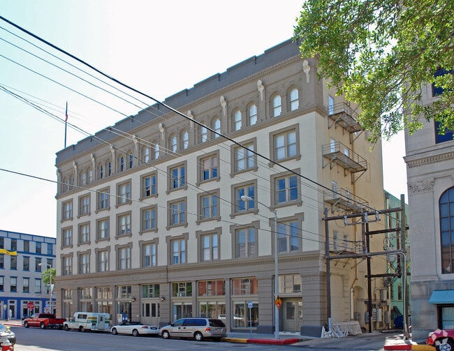
415 22Nd St, Galveston, TX 77550

NEARBY LISTINGS FOR SALE OR LEASE
Property Detail
415 22Nd St
4769-0000-0001-100
The Lofts @ The Texas Bldg Condos (2005)
Commercialnec
THE LOFTS @ THE TEXAS BLDG CONDOS (2005) ABST 628 UNIT 1A & 17.129% INT IN COMMON AREA
AE
Galveston
48167C0441G
Texas
2024
0.02 AC
2025
East-Southeast Far
724500
Houston
5,400 SF
Houston-Pasadena-The Woodlands, TX
DEMOGRAPHICS near 415 22Nd St
1 Mile
3 Mile
5 Mile
2024 Total Population
12,820
41,801
55,173
2029 Population
13,854
44,852
59,120
Pop Growth 2024-2029
+ 8.07%
+ 7.30%
+ 7.15%
Average Age
42
42
42
2024 Total Households
6,048
17,904
23,875
HH Growth 2024-2029
+ 8.32%
+ 7.89%
+ 7.72%
Median Household Inc
$46,960
$48,191
$49,874
Avg Household Size
2.00
2.10
2.10
2024 Avg HH Vehicles
1.00
1.00
1.00
Median Home Value
$317,877
$267,786
$271,812
Median Year Built
1953
1961
1968
Nearby Places
Map Layers
Map Styles
 Street
 Aerial
- Restaurants
- Banks
- Shops
- Fitness
- Groceries
PUBLIC TRANSPORTATION
AIRPORT
William P Hobby
DRIVE
WALK
Distance
William P Hobby
58 min
41.7 mi
Freight Ports
Port of Galveston
DRIVE
WALK
Distance
Port of Galveston
4 min
2.1 mi
Nearby Properties
Address
Land Use
TOTAL SIZE
Lot Size
Zoning
Address
Land Use
TOTAL SIZE
Lot Size
Zoning
1,024,737 SF
6.16 AC
I
Address
Land Use
TOTAL SIZE
Lot Size
Zoning
566,062 SF
40.20 AC
Address
Land Use
TOTAL SIZE
Lot Size
Zoning
1,459,569 SF
11.51 AC
MF1
Address
Land Use
TOTAL SIZE
Lot Size
Zoning
457,632 SF
2.88 AC
I
Address
Land Use
TOTAL SIZE
Lot Size
Zoning
2,181,183 SF
236.11 AC
HI
Address
Land Use
TOTAL SIZE
Lot Size
Zoning
161,300 SF
Address
Land Use
TOTAL SIZE
Lot Size
Zoning
316,590 SF
2.97 AC
I
Address
Land Use
TOTAL SIZE
Lot Size
Zoning
376,136 SF
2.88 AC
I
Address
Land Use
TOTAL SIZE
Lot Size
Zoning
223,591 SF
Address
Land Use
TOTAL SIZE
Lot Size
Zoning
160,000 SF
1.79 AC
I
Address
Land Use
TOTAL SIZE
Lot Size
Zoning
226,301 SF
5.93 AC
I
Address
Land Use
TOTAL SIZE
Lot Size
Zoning
157,959 SF
1.79 AC
Address
Land Use
TOTAL SIZE
Lot Size
Zoning
228,895 SF
11.41 AC
R
Address
Land Use
TOTAL SIZE
Lot Size
Zoning
161,346 SF
1.79 AC
Address
Land Use
TOTAL SIZE
Lot Size
Zoning
346,554 SF
2.41 AC
I
Address
Land Use
TOTAL SIZE
Lot Size
Zoning
246,626 SF
4 AC
I
Address
Land Use
TOTAL SIZE
Lot Size
Zoning
346,355 SF
5.91 AC
Address
Land Use
TOTAL SIZE
Lot Size
Zoning
117,219 SF
2.27 AC
I
Address
Land Use
TOTAL SIZE
Lot Size
Zoning
153,637 SF
4.52 AC
R
Address
Land Use
TOTAL SIZE
Lot Size
Zoning
178,711 SF
1.45 AC
I
Address
Land Use
TOTAL SIZE
Lot Size
Zoning
169,052 SF
4.18 AC
R
Address
Land Use
TOTAL SIZE
Lot Size
Zoning
182,000 SF
41.90 AC
Address
Land Use
TOTAL SIZE
Lot Size
Zoning
Address
Land Use
TOTAL SIZE
Lot Size
Zoning
149,422 SF
1.79 AC
I
Address
Land Use
TOTAL SIZE
Lot Size
Zoning
122,655 SF
1.31 AC
I
Address
Land Use
TOTAL SIZE
Lot Size
Zoning
176,242 SF
2.03 AC
MF2
Address
Land Use
TOTAL SIZE
Lot Size
Zoning
79,660 SF
2.63 AC
I
Address
Land Use
TOTAL SIZE
Lot Size
Zoning
88,994 SF
3.03 AC
R
Address
Land Use
TOTAL SIZE
Lot Size
Zoning
397,664 SF
1.79 AC
CB
Address
Land Use
TOTAL SIZE
Lot Size
Zoning
137,112 SF
318 AC
The World's #1 Commercial Real Estate Marketplace
Connect with us
© 2026 CoStar Group
The information above has been obtained from sources believed reliable. While we do not doubt its accuracy we have not verified it and make no guarantee, warranty or representation about it. It is your responsibility to independently confirm its accuracy and completeness. Any projections, opinions, assumptions, or estimates used are for example only and do not represent the current or future performance of the property. The value of this transaction to you depends on tax and other factors which should be evaluated by your tax, financial, and legal advisors. You and your advisors should conduct a careful, independent investigation of the property to determine to your satisfaction the suitability of the property for your needs.