Property Record
415 N Taylor St, Fallon, NV 89406
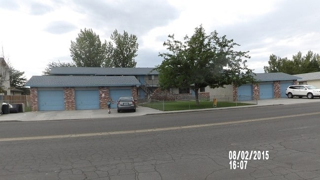

This Property Is For Sale
Property Detail
415 N Taylor St
001-024-18
1986-87,POR OF NE1/4-SE1/4,& NW1/4-SW1/4,MEADOW VALLEY SUBDIVISION UNIT #1,LOT/BLK,FILE #202462,RECORDED: JANUARY 10, 1984,PARCEL #001-024-18
Multifamilydwelling
Churchill
RC;RES COM
Nevada
B and X Area of moderate flood hazard, usually the area between the limits of the 100-year and 500-year floods.
27
2024
0.33 AC
2025
Fallon
950302
Reno/Sparks
5,980 SF
Fallon, NV
NEARBY LISTINGS FOR SALE OR LEASE
-
-
View all Fallon listings for sale on LoopNet.com
DEMOGRAPHICS near 415 N Taylor St
1 mile
3 mile
5 mile
2025 Total Population
7,020
15,344
20,692
2030 Population
7,105
15,573
21,019
Pop Growth 2025-2030
+ 1.21%
+ 1.49%
+ 1.58%
Average Age
39
41
41
2025 Total Households
2,940
6,276
8,250
HH Growth 2025-2030
+ 1.36%
+ 1.56%
+ 1.62%
Median Household Inc
$66,475
$70,025
$72,748
Avg Household Size
2.30
2.40
2.40
2025 Avg HH Vehicles
2.00
2.00
2.00
Median Home Value
$309,649
$314,972
$325,019
Median Year Built
1982
1984
1986
Nearby Places
Map Layers
Map Styles
 Street
 Aerial
Transit
 Traffic
 Biking
Places
Listings with unknown addresses are not visible on the map
- Restaurants
- Banks
- Shops
- Fitness
- Groceries
Nearby Properties
Address
Land Use
TOTAL SIZE
Lot Size
Zoning
Address
Land Use
TOTAL SIZE
Lot Size
Zoning
112,210 SF
17.70 AC
C2;GENERAL
Address
Land Use
TOTAL SIZE
Lot Size
Zoning
307,680 SF
66.31 AC
R1-5K
Address
Land Use
TOTAL SIZE
Lot Size
Zoning
81.80 AC
Address
Land Use
TOTAL SIZE
Lot Size
Zoning
81,350 SF
31.50 AC
LI
Address
Land Use
TOTAL SIZE
Lot Size
Zoning
107,708 SF
77.77 AC
C2;GENERAL
Address
Land Use
TOTAL SIZE
Lot Size
Zoning
44,440 SF
1.69 AC
C2
Address
Land Use
TOTAL SIZE
Lot Size
Zoning
200,656 SF
21.53 AC
C1;TR RES/
Address
Land Use
TOTAL SIZE
Lot Size
Zoning
117,392 SF
9.07 AC
RC
Address
Land Use
TOTAL SIZE
Lot Size
Zoning
40.13 AC
A10
Address
Land Use
TOTAL SIZE
Lot Size
Zoning
149,624 SF
14.60 AC
R1-5K
Address
Land Use
TOTAL SIZE
Lot Size
Zoning
32,181 SF
37.53 AC
C2;GENERAL
Address
Land Use
TOTAL SIZE
Lot Size
Zoning
72,173 SF
17.26 AC
A5
Address
Land Use
TOTAL SIZE
Lot Size
Zoning
29,385 SF
10 AC
R2;MULTI 1
Address
Land Use
TOTAL SIZE
Lot Size
Zoning
2,432 SF
355 AC
A10
Address
Land Use
TOTAL SIZE
Lot Size
Zoning
63,187 SF
2.51 AC
C2;GENERAL
Address
Land Use
TOTAL SIZE
Lot Size
Zoning
9,593 SF
442 AC
I;INDUSTRI
Address
Land Use
TOTAL SIZE
Lot Size
Zoning
46,041 SF
12.19 AC
I
Address
Land Use
TOTAL SIZE
Lot Size
Zoning
58,616 SF
28.24 AC
R2;MULTI 1
Address
Land Use
TOTAL SIZE
Lot Size
Zoning
49,146 SF
6.62 AC
C2
Address
Land Use
TOTAL SIZE
Lot Size
Zoning
63,020 SF
5.52 AC
C2
Address
Land Use
TOTAL SIZE
Lot Size
Zoning
3,127 SF
2.03 AC
R1;SFR 1HS
Address
Land Use
TOTAL SIZE
Lot Size
Zoning
12,764 SF
8.70 AC
R15K
Address
Land Use
TOTAL SIZE
Lot Size
Zoning
14,869 SF
1.18 AC
I;INDUSTRI
Address
Land Use
TOTAL SIZE
Lot Size
Zoning
37,909 SF
6.05 AC
C2;GENERAL
Address
Land Use
TOTAL SIZE
Lot Size
Zoning
15,792 SF
2.48 AC
C2
Address
Land Use
TOTAL SIZE
Lot Size
Zoning
22,245 SF
2.39 AC
C1;TR RES/
Address
Land Use
TOTAL SIZE
Lot Size
Zoning
44,189 SF
3.76 AC
C2
Address
Land Use
TOTAL SIZE
Lot Size
Zoning
10.59 AC
LI
Address
Land Use
TOTAL SIZE
Lot Size
Zoning
39,028 SF
2 AC
C2;GENERAL
Address
Land Use
TOTAL SIZE
Lot Size
Zoning
40,903 SF
7.35 AC
R1-5K
The World's #1 Commercial Real Estate Marketplace
Connect with us
© 2026 CoStar Group
The information above has been obtained from sources believed reliable. While we do not doubt its accuracy we have not verified it and make no guarantee, warranty or representation about it. It is your responsibility to independently confirm its accuracy and completeness. Any projections, opinions, assumptions, or estimates used are for example only and do not represent the current or future performance of the property. The value of this transaction to you depends on tax and other factors which should be evaluated by your tax, financial, and legal advisors. You and your advisors should conduct a careful, independent investigation of the property to determine to your satisfaction the suitability of the property for your needs.