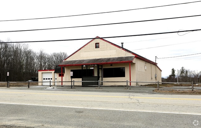
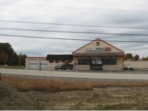
Property Record
415 Emerson Ave, Hampstead, NH 03841
NEARBY LISTINGS FOR SALE OR LEASE
Property Detail
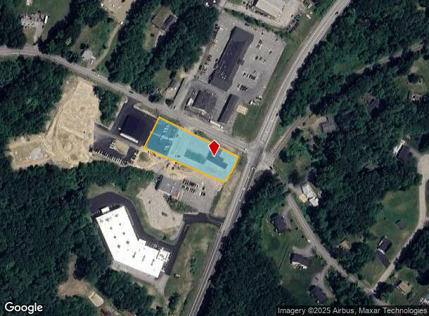
415 Emerson Ave
Boston-Cambridge-Newton, MA-NH
Rockingham
HMSD M:00012 B:000015 L:000004
New Hampshire
Commercialbuilding
4
2024
1.08 AC
2024
Rockingham
104101
Boston
2,196 SF
DEMOGRAPHICS near 415 Emerson Ave
1 Mile
3 Mile
5 Mile
2024 Total Population
2,794
14,419
38,343
2029 Population
2,840
14,840
39,535
Pop Growth 2024-2029
+ 1.65%
+ 2.92%
+ 3.11%
Average Age
45
44
44
2024 Total Households
1,153
5,653
14,721
HH Growth 2024-2029
+ 1.47%
+ 2.79%
+ 3.00%
Median Household Inc
$103,865
$107,893
$113,196
Avg Household Size
2.40
2.50
2.60
2024 Avg HH Vehicles
2.00
2.00
2.00
Median Home Value
$411,702
$393,779
$396,616
Median Year Built
1985
1983
1982
Nearby Places
Map Layers
Map Styles
 Street
 Aerial
- Restaurants
- Banks
- Shops
- Fitness
- Groceries
PUBLIC TRANSPORTATION
AIRPORT
Manchester Boston Regional
DRIVE
WALK
Distance
Manchester Boston Regional
43 min
25.0 mi
Portsmouth International at Pease
DRIVE
WALK
Distance
Portsmouth International at Pease
54 min
30.9 mi
Freight Ports
Port of Boston
DRIVE
WALK
Distance
Port of Boston
65 min
45.0 mi
Nearby Properties
Address
Land Use
TOTAL SIZE
Lot Size
Zoning
Address
Land Use
TOTAL SIZE
Lot Size
Zoning
82,926 SF
40.38 AC
A-RES
Address
Land Use
TOTAL SIZE
Lot Size
Zoning
5,553 SF
44.71 AC
A-RES
Address
Land Use
TOTAL SIZE
Lot Size
Zoning
89,227 SF
89.88 AC
A-RES
Address
Land Use
TOTAL SIZE
Lot Size
Zoning
12,187 SF
18.51 AC
A-RES
Address
Land Use
TOTAL SIZE
Lot Size
Zoning
58,661 SF
9.53 AC
A-RES
Address
Land Use
TOTAL SIZE
Lot Size
Zoning
18,019 SF
10 AC
C2 C
Address
Land Use
TOTAL SIZE
Lot Size
Zoning
50,210 SF
10.93 AC
C1 C
Address
Land Use
TOTAL SIZE
Lot Size
Zoning
863 SF
14.79 AC
B-RES
Address
Land Use
TOTAL SIZE
Lot Size
Zoning
1,358 SF
74.43 AC
D-MHPM
Address
Land Use
TOTAL SIZE
Lot Size
Zoning
1,691 SF
112.47 AC
D-MHPM
Address
Land Use
TOTAL SIZE
Lot Size
Zoning
25,614 SF
15.39 AC
C1 C
Address
Land Use
TOTAL SIZE
Lot Size
Zoning
52,901 SF
15 AC
DVDVIL
Address
Land Use
TOTAL SIZE
Lot Size
Zoning
115,964 SF
8.17 AC
C2 C
Address
Land Use
TOTAL SIZE
Lot Size
Zoning
5,508 SF
1.80 AC
C2 C
Address
Land Use
TOTAL SIZE
Lot Size
Zoning
15,396 SF
1.80 AC
C2 C
Address
Land Use
TOTAL SIZE
Lot Size
Zoning
480 SF
A-RES
Address
Land Use
TOTAL SIZE
Lot Size
Zoning
33,757 SF
6.43 AC
C2 C
Address
Land Use
TOTAL SIZE
Lot Size
Zoning
4,932 SF
15.62 AC
A-RES
Address
Land Use
TOTAL SIZE
Lot Size
Zoning
16,368 SF
7.67 AC
C1 C
Address
Land Use
TOTAL SIZE
Lot Size
Zoning
71,420 SF
18.50 AC
C2 C
Address
Land Use
TOTAL SIZE
Lot Size
Zoning
33,519 SF
6.70 AC
C2 C
Address
Land Use
TOTAL SIZE
Lot Size
Zoning
28,698 SF
6.29 AC
C1 C
Address
Land Use
TOTAL SIZE
Lot Size
Zoning
4,003 SF
7.97 AC
A-RES
Address
Land Use
TOTAL SIZE
Lot Size
Zoning
32,533 SF
9.46 AC
C2 C
Address
Land Use
TOTAL SIZE
Lot Size
Zoning
10,559 SF
1.52 AC
C1 C
Address
Land Use
TOTAL SIZE
Lot Size
Zoning
12,796 SF
7.09 AC
A-RES
Address
Land Use
TOTAL SIZE
Lot Size
Zoning
7,463 SF
3.05 AC
A-RES
Address
Land Use
TOTAL SIZE
Lot Size
Zoning
842 SF
13.30 AC
B-RES
Address
Land Use
TOTAL SIZE
Lot Size
Zoning
5,281 SF
71.16 AC
A-RES
Address
Land Use
TOTAL SIZE
Lot Size
Zoning
5,334 SF
4.80 AC
A-RES
The World's #1 Commercial Real Estate Marketplace
Connect with us
© 2025 CoStar Group
The information above has been obtained from sources believed reliable. While we do not doubt its accuracy we have not verified it and make no guarantee, warranty or representation about it. It is your responsibility to independently confirm its accuracy and completeness. Any projections, opinions, assumptions, or estimates used are for example only and do not represent the current or future performance of the property. The value of this transaction to you depends on tax and other factors which should be evaluated by your tax, financial, and legal advisors. You and your advisors should conduct a careful, independent investigation of the property to determine to your satisfaction the suitability of the property for your needs.