Property Record
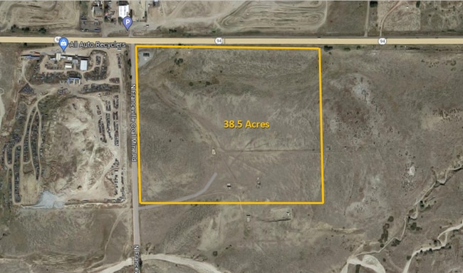
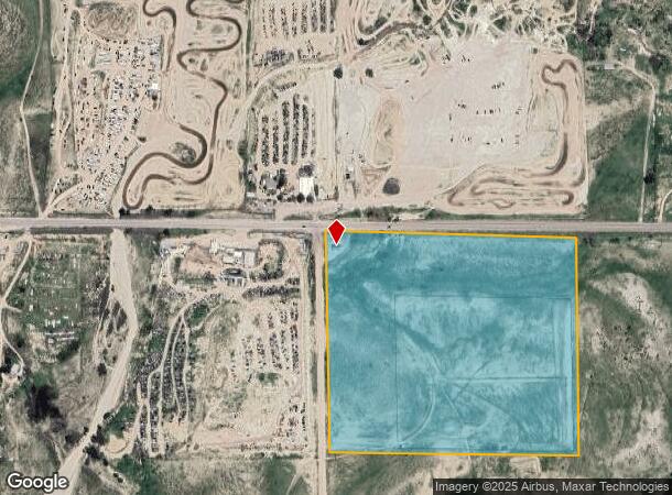
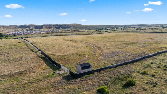
415 N Franceville Coal Mine Rd, Colorado Springs, CO 80929
This Property Is For Sale
NEARBY LISTINGS FOR SALE OR LEASE
Property Detail
415 N Franceville Coal Mine Rd
Colorado Springs, CO
TR OF LAND IN THE NW4 SEC 17 AND NE4 SEC 18-14-64 DESC AS FOLS: COM AT THE COR COMMON TO SECS 7,8,17 AND 18, TH S89-41-55E ALG THE N LN OF SD SEC 17 2577.58 FT, TH S84-47-23W 1378.53 FT TO THE SLY ROW LN OF HWY 94 AND THE POB; TH S01-05-25E 1205.80 F
44000-00-565
El Paso
Pasture
Colorado
2024
38.90 AC
2025
Southeast
004603
Colorado Springs
DEMOGRAPHICS near 415 N Franceville Coal Mine Rd
1 Mile
3 Mile
5 Mile
2024 Total Population
22
803
5,870
2029 Population
23
831
6,049
Pop Growth 2024-2029
+ 4.55%
+ 3.49%
+ 3.05%
Average Age
44
40
37
2024 Total Households
8
288
2,018
HH Growth 2024-2029
+ 12.50%
+ 3.82%
+ 3.17%
Median Household Inc
$99,999
$88,970
$88,565
Avg Household Size
2.50
2.70
2.80
2024 Avg HH Vehicles
3.00
3.00
3.00
Median Home Value
$499,999
$467,123
$428,929
Median Year Built
1992
1994
2003
Nearby Places
- Restaurants
- Banks
- Shops
- Fitness
- Groceries
PUBLIC TRANSPORTATION
AIRPORT
City of Colorado Springs Municipal
DRIVE
WALK
Distance
City of Colorado Springs Municipal
14 min
8.0 mi
Freight Ports
Tulsa Port Of Catoosa
DRIVE
WALK
Distance
Tulsa Port Of Catoosa
725 min
687.1 mi
Nearby Properties
Address
Land Use
TOTAL SIZE
Lot Size
Zoning
Address
Land Use
TOTAL SIZE
Lot Size
Zoning
522.67 AC
PK SS
Address
Land Use
TOTAL SIZE
Lot Size
Zoning
700.86 AC
RR-5
Address
Land Use
TOTAL SIZE
Lot Size
Zoning
5,158 SF
40 AC
PK
Address
Land Use
TOTAL SIZE
Lot Size
Zoning
4,223 SF
25 AC
PK
Address
Land Use
TOTAL SIZE
Lot Size
Zoning
3,024 SF
35.33 AC
PK
Address
Land Use
TOTAL SIZE
Lot Size
Zoning
320 AC
RR-5
Address
Land Use
TOTAL SIZE
Lot Size
Zoning
3,060 SF
40 AC
PK
Address
Land Use
TOTAL SIZE
Lot Size
Zoning
2,636 SF
40 AC
PK
Address
Land Use
TOTAL SIZE
Lot Size
Zoning
1,751 SF
8.76 AC
RR-5
Address
Land Use
TOTAL SIZE
Lot Size
Zoning
318.80 AC
RR-5
Address
Land Use
TOTAL SIZE
Lot Size
Zoning
1,400 SF
5 AC
PK
Address
Land Use
TOTAL SIZE
Lot Size
Zoning
639 SF
143.25 AC
PK
Address
Land Use
TOTAL SIZE
Lot Size
Zoning
160 AC
RR-5
Address
Land Use
TOTAL SIZE
Lot Size
Zoning
25.63 AC
PIP2
Address
Land Use
TOTAL SIZE
Lot Size
Zoning
9.41 AC
R-1 6/CR
Address
Land Use
TOTAL SIZE
Lot Size
Zoning
85.61 AC
PK SS
Address
Land Use
TOTAL SIZE
Lot Size
Zoning
10 AC
PK
Address
Land Use
TOTAL SIZE
Lot Size
Zoning
80 AC
PK
Address
Land Use
TOTAL SIZE
Lot Size
Zoning
594 SF
75.66 AC
PK
Address
Land Use
TOTAL SIZE
Lot Size
Zoning
5,440 SF
10.46 AC
RR-5
Address
Land Use
TOTAL SIZE
Lot Size
Zoning
40.30 AC
PK
Address
Land Use
TOTAL SIZE
Lot Size
Zoning
21.50 AC
RR-5
Address
Land Use
TOTAL SIZE
Lot Size
Zoning
1,020 SF
3.45 AC
Address
Land Use
TOTAL SIZE
Lot Size
Zoning
5.74 AC
RR-5
Address
Land Use
TOTAL SIZE
Lot Size
Zoning
13.76 AC
RR-5
Address
Land Use
TOTAL SIZE
Lot Size
Zoning
4.88 AC
RR-5
Address
Land Use
TOTAL SIZE
Lot Size
Zoning
4.88 AC
RR-5
Address
Land Use
TOTAL SIZE
Lot Size
Zoning
1,280 SF
15.52 AC
CS
Address
Land Use
TOTAL SIZE
Lot Size
Zoning
1 AC
RR-5
Address
Land Use
TOTAL SIZE
Lot Size
Zoning
113.96 AC
A-5 RR-5
The World's #1 Commercial Real Estate Marketplace
Connect with us
© 2025 CoStar Group
The information above has been obtained from sources believed reliable. While we do not doubt its accuracy we have not verified it and make no guarantee, warranty or representation about it. It is your responsibility to independently confirm its accuracy and completeness. Any projections, opinions, assumptions, or estimates used are for example only and do not represent the current or future performance of the property. The value of this transaction to you depends on tax and other factors which should be evaluated by your tax, financial, and legal advisors. You and your advisors should conduct a careful, independent investigation of the property to determine to your satisfaction the suitability of the property for your needs.