Property Record
415 Highway 31 S, Warrior, AL 35180


NEARBY LISTINGS FOR SALE OR LEASE
-
-
View all Warrior listings for sale on LoopNet.com
Property Detail
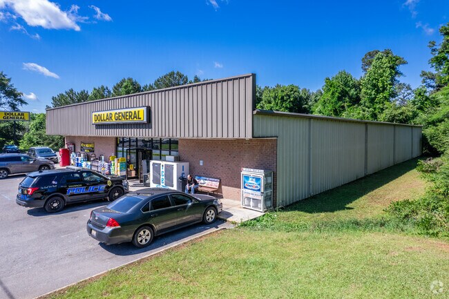
415 Highway 31 S
03-00-24-2-004-006.000
COM SW COR OF NW 1/4 SEC 24 TP 14S R 3W TH N 1250 FT TH E 310 FT TO POB TH CONT E 210 FT TH SELY 85 FT TH SWLY 25 FT TH SELY 190 FT TH WLY 280 FT TH N 205 FT TO POB SECT 24 TWSP 14S RANGE 3W
Departmentstore
Jefferson
X
Alabama
01009C0425F
1.18 AC
2023
Fultondale
2024
Birmingham
011401
Birmingham-Hoover, AL
10,458 SF
DEMOGRAPHICS near 415 Highway 31 S
1 Mile
3 Mile
5 Mile
2024 Total Population
1,270
6,270
17,247
2029 Population
1,251
6,210
17,045
Pop Growth 2024-2029
(1.50%)
(0.96%)
(1.17%)
Average Age
42
40
40
2024 Total Households
555
2,464
6,511
HH Growth 2024-2029
(1.44%)
(1.01%)
(1.20%)
Median Household Inc
$32,840
$60,752
$72,297
Avg Household Size
2.30
2.50
2.60
2024 Avg HH Vehicles
2.00
2.00
2.00
Median Home Value
$104,895
$172,847
$193,983
Median Year Built
1969
1987
1992
Nearby Places
Map Layers
Map Styles
 Street
 Aerial
- Restaurants
- Banks
- Shops
- Fitness
- Groceries
PUBLIC TRANSPORTATION
AIRPORT
Birmingham-Shuttlesworth International
DRIVE
WALK
Distance
Birmingham-Shuttlesworth International
35 min
27.7 mi
Nearby Properties
Address
Land Use
TOTAL SIZE
Lot Size
Zoning
Address
Land Use
TOTAL SIZE
Lot Size
Zoning
55,467 SF
7.30 AC
GB
Address
Land Use
TOTAL SIZE
Lot Size
Zoning
13,988 SF
1.61 AC
B
Address
Land Use
TOTAL SIZE
Lot Size
Zoning
6,296 SF
2.10 AC
Address
Land Use
TOTAL SIZE
Lot Size
Zoning
6,370 SF
4.14 AC
B3
Address
Land Use
TOTAL SIZE
Lot Size
Zoning
6,460 SF
5.20 AC
Address
Land Use
TOTAL SIZE
Lot Size
Zoning
6,863 SF
0.70 AC
C1-A
Address
Land Use
TOTAL SIZE
Lot Size
Zoning
34,552 SF
2.53 AC
I1
Address
Land Use
TOTAL SIZE
Lot Size
Zoning
5,100 SF
1 AC
B
Address
Land Use
TOTAL SIZE
Lot Size
Zoning
6,509 SF
4.09 AC
B
Address
Land Use
TOTAL SIZE
Lot Size
Zoning
10,000 SF
0.64 AC
C1
Address
Land Use
TOTAL SIZE
Lot Size
Zoning
41,296 SF
2.12 AC
B
Address
Land Use
TOTAL SIZE
Lot Size
Zoning
23,306 SF
1.81 AC
B2
Address
Land Use
TOTAL SIZE
Lot Size
Zoning
1,401 SF
0.90 AC
C1 A
Address
Land Use
TOTAL SIZE
Lot Size
Zoning
6,061 SF
3.35 AC
Address
Land Use
TOTAL SIZE
Lot Size
Zoning
10,125 SF
1.76 AC
GB
Address
Land Use
TOTAL SIZE
Lot Size
Zoning
10,672 SF
1.27 AC
C1
Address
Land Use
TOTAL SIZE
Lot Size
Zoning
3,437 SF
0.84 AC
R1&B
Address
Land Use
TOTAL SIZE
Lot Size
Zoning
10,000 SF
8.20 AC
Address
Land Use
TOTAL SIZE
Lot Size
Zoning
7,225 SF
0.93 AC
B1
Address
Land Use
TOTAL SIZE
Lot Size
Zoning
9,106 SF
0.78 AC
B1
Address
Land Use
TOTAL SIZE
Lot Size
Zoning
5,822 SF
0.71 AC
R3
Address
Land Use
TOTAL SIZE
Lot Size
Zoning
2,397 SF
1.46 AC
C1-A
Address
Land Use
TOTAL SIZE
Lot Size
Zoning
4.30 AC
B
Address
Land Use
TOTAL SIZE
Lot Size
Zoning
11,111 SF
0.95 AC
R2
Address
Land Use
TOTAL SIZE
Lot Size
Zoning
2,400 SF
1.03 AC
Address
Land Use
TOTAL SIZE
Lot Size
Zoning
11,526 SF
3.67 AC
R1
Address
Land Use
TOTAL SIZE
Lot Size
Zoning
13,620 SF
0.60 AC
A1
Address
Land Use
TOTAL SIZE
Lot Size
Zoning
18,900 SF
3.50 AC
B
Address
Land Use
TOTAL SIZE
Lot Size
Zoning
10,520 SF
1.80 AC
C1
Address
Land Use
TOTAL SIZE
Lot Size
Zoning
3,636 SF
1.40 AC
The World's #1 Commercial Real Estate Marketplace
Connect with us
© 2025 CoStar Group
The information above has been obtained from sources believed reliable. While we do not doubt its accuracy we have not verified it and make no guarantee, warranty or representation about it. It is your responsibility to independently confirm its accuracy and completeness. Any projections, opinions, assumptions, or estimates used are for example only and do not represent the current or future performance of the property. The value of this transaction to you depends on tax and other factors which should be evaluated by your tax, financial, and legal advisors. You and your advisors should conduct a careful, independent investigation of the property to determine to your satisfaction the suitability of the property for your needs.