Property Record
415 Lilac St, Circle Pines, MN 55014
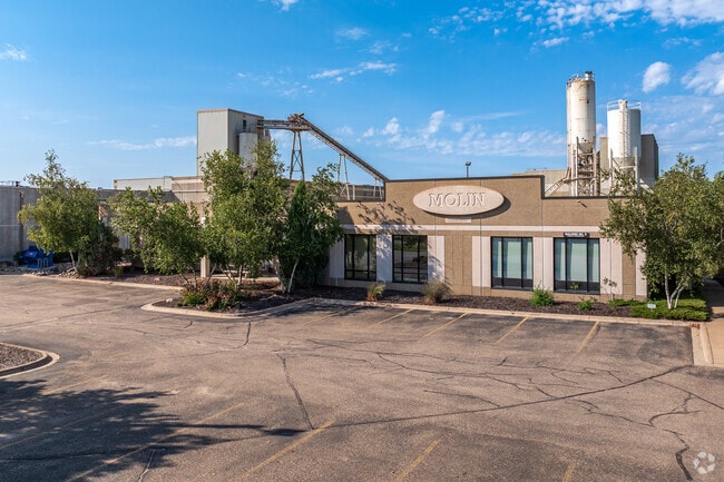

Property Detail
415 Lilac St
08-31-22-33-0003
THAT PRT OF SW1/4 OF SW1/4 OF SEC 8 TWP 31 RGE 22 DESC AS FOL: COM AT SE COR THEREOF, TH W ALG S LINE OF SD 1/4 1/4, 260 FT T
Industrialgeneral
ANOKA
B and X Area of moderate flood hazard, usually the area between the limits of the 100-year and 500-year floods.
Minnesota
2026
11 AC
2026
North Central
050233
Minneapolis/St Paul
93,001 SF
Minneapolis-St. Paul-Bloomington, MN-WI
NEARBY LISTINGS FOR SALE OR LEASE
-
-
View all Circle Pines listings for sale on LoopNet.com
DEMOGRAPHICS near 415 Lilac St
1 mile
3 mile
5 mile
2025 Total Population
4,146
22,787
74,204
2030 Population
4,235
23,627
76,909
Pop Growth 2025-2030
+ 2.15%
+ 3.69%
+ 3.65%
Average Age
39
40
40
2025 Total Households
1,289
7,547
25,770
HH Growth 2025-2030
+ 2.48%
+ 3.75%
+ 3.62%
Median Household Inc
$109,214
$110,063
$121,596
Avg Household Size
2.80
2.80
2.80
2025 Avg HH Vehicles
2.00
2.00
2.00
Median Home Value
$363,457
$377,751
$418,594
Median Year Built
1996
1989
1996
Nearby Places
Map Layers
Map Styles
 Street
 Aerial
Layers
 Traffic
 Biking
Places
Listings with unknown addresses are not visible on the map
- Restaurants
- Banks
- Shops
- Fitness
- Groceries
PUBLIC TRANSPORTATION
AIRPORT
Minneapolis-St Paul International/Wold-Chamberlain
Drive
Walk
Distance
Minneapolis-St Paul International/Wold-Chamberlain
40 min
27.6 mi
Freight Ports
Port Milwaukee
Drive
Walk
Distance
Port Milwaukee
385 min
349.8 mi
Nearby Properties
Address
Land Use
TOTAL SIZE
Lot Size
Zoning
Address
Land Use
TOTAL SIZE
Lot Size
Zoning
226,201 SF
70.59 AC
Address
Land Use
TOTAL SIZE
Lot Size
Zoning
156,499 SF
81.20 AC
Address
Land Use
TOTAL SIZE
Lot Size
Zoning
239,389 SF
5.73 AC
Address
Land Use
TOTAL SIZE
Lot Size
Zoning
Address
Land Use
TOTAL SIZE
Lot Size
Zoning
152,721 SF
Address
Land Use
TOTAL SIZE
Lot Size
Zoning
265,400 SF
13.53 AC
Address
Land Use
TOTAL SIZE
Lot Size
Zoning
74,366 SF
10 AC
Address
Land Use
TOTAL SIZE
Lot Size
Zoning
46,557 SF
9.27 AC
Address
Land Use
TOTAL SIZE
Lot Size
Zoning
223,763 SF
24.89 AC
Address
Land Use
TOTAL SIZE
Lot Size
Zoning
48,260 SF
10.38 AC
Address
Land Use
TOTAL SIZE
Lot Size
Zoning
180,712 SF
15.95 AC
Address
Land Use
TOTAL SIZE
Lot Size
Zoning
43,132 SF
37.89 AC
Address
Land Use
TOTAL SIZE
Lot Size
Zoning
52,981 SF
5.27 AC
Address
Land Use
TOTAL SIZE
Lot Size
Zoning
185,498 SF
25.01 AC
Address
Land Use
TOTAL SIZE
Lot Size
Zoning
32,314 SF
4.37 AC
Address
Land Use
TOTAL SIZE
Lot Size
Zoning
243,028 SF
24.35 AC
Address
Land Use
TOTAL SIZE
Lot Size
Zoning
Address
Land Use
TOTAL SIZE
Lot Size
Zoning
109,470 SF
12.67 AC
Address
Land Use
TOTAL SIZE
Lot Size
Zoning
120,680 SF
11.46 AC
Address
Land Use
TOTAL SIZE
Lot Size
Zoning
79,827 SF
2.81 AC
Address
Land Use
TOTAL SIZE
Lot Size
Zoning
6,316 SF
28.25 AC
Address
Land Use
TOTAL SIZE
Lot Size
Zoning
Address
Land Use
TOTAL SIZE
Lot Size
Zoning
67,688 SF
40 AC
Address
Land Use
TOTAL SIZE
Lot Size
Zoning
3,947 SF
40 AC
Address
Land Use
TOTAL SIZE
Lot Size
Zoning
881 SF
8.96 AC
Address
Land Use
TOTAL SIZE
Lot Size
Zoning
83,252 SF
7.75 AC
Address
Land Use
TOTAL SIZE
Lot Size
Zoning
75,440 SF
5.98 AC
Address
Land Use
TOTAL SIZE
Lot Size
Zoning
140,684 SF
3.65 AC
Address
Land Use
TOTAL SIZE
Lot Size
Zoning
51,042 SF
8.73 AC
Address
Land Use
TOTAL SIZE
Lot Size
Zoning
1,144 SF
39 AC
The World's #1 Commercial Real Estate Marketplace
Connect with us
© 2026 CoStar Group
The information above has been obtained from sources believed reliable. While we do not doubt its accuracy we have not verified it and make no guarantee, warranty or representation about it. It is your responsibility to independently confirm its accuracy and completeness. Any projections, opinions, assumptions, or estimates used are for example only and do not represent the current or future performance of the property. The value of this transaction to you depends on tax and other factors which should be evaluated by your tax, financial, and legal advisors. You and your advisors should conduct a careful, independent investigation of the property to determine to your satisfaction the suitability of the property for your needs.