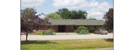
Property Record
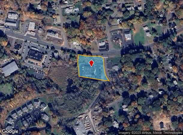
415 Middlebury Rd, Middlebury, CT 06762
NEARBY LISTINGS FOR SALE OR LEASE
Property Detail
415 Middlebury Rd
MIDD-000408-000000-000056
New Haven
Commercialbuilding
Connecticut
X
56
09009C0111H
1 AC
2025
Middlebury
2025
Westchester/So Connecticut
344100
New Haven-Milford, CT
7,028 SF
DEMOGRAPHICS near 415 Middlebury Rd
1 Mile
3 Mile
5 Mile
2024 Total Population
3,141
38,236
138,427
2029 Population
3,156
38,171
137,859
Pop Growth 2024-2029
+ 0.48%
(0.17%)
(0.41%)
Average Age
44
41
39
2024 Total Households
1,209
14,986
53,721
HH Growth 2024-2029
+ 0.41%
(0.27%)
(0.42%)
Median Household Inc
$115,716
$71,656
$60,183
Avg Household Size
2.60
2.40
2.50
2024 Avg HH Vehicles
2.00
2.00
2.00
Median Home Value
$346,712
$204,573
$195,982
Median Year Built
1969
1965
1958
Nearby Places
Map Layers
Map Styles
 Street
 Aerial
- Restaurants
- Banks
- Shops
- Fitness
- Groceries
PUBLIC TRANSPORTATION
COMMUTER RAIL
Waterbury Station (New Haven Line - Metro-North Commuter Railroad Company (Metro-North))
DRIVE
WALK
Distance
Waterbury Station (New Haven Line - Metro-North Commuter Railroad Company (Metro-North))
9 min
4.2 mi
Naugatuck Station (New Haven Line - Metro-North Commuter Railroad Company (Metro-North))
DRIVE
WALK
Distance
Naugatuck Station (New Haven Line - Metro-North Commuter Railroad Company (Metro-North))
9 min
5.0 mi
AIRPORT
Tweed/New Haven
DRIVE
WALK
Distance
Tweed/New Haven
48 min
27.8 mi
Bradley International
DRIVE
WALK
Distance
Bradley International
68 min
47.9 mi
Freight Ports
Port of New Haven
DRIVE
WALK
Distance
Port of New Haven
42 min
25.6 mi
Nearby Properties
Address
Land Use
TOTAL SIZE
Lot Size
Zoning
Address
Land Use
TOTAL SIZE
Lot Size
Zoning
16.10 AC
CO
Address
Land Use
TOTAL SIZE
Lot Size
Zoning
156,279 SF
12.13 AC
RL
Address
Land Use
TOTAL SIZE
Lot Size
Zoning
149,058 SF
31.04 AC
RS-12
Address
Land Use
TOTAL SIZE
Lot Size
Zoning
182,949 SF
9.10 AC
RS
Address
Land Use
TOTAL SIZE
Lot Size
Zoning
36.10 AC
RS
Address
Land Use
TOTAL SIZE
Lot Size
Zoning
76,264 SF
15.03 AC
RS
Address
Land Use
TOTAL SIZE
Lot Size
Zoning
49,768 SF
4.35 AC
CO
Address
Land Use
TOTAL SIZE
Lot Size
Zoning
26.40 AC
RS-12
Address
Land Use
TOTAL SIZE
Lot Size
Zoning
63,288 SF
2.60 AC
RH
Address
Land Use
TOTAL SIZE
Lot Size
Zoning
81.26 AC
R80
Address
Land Use
TOTAL SIZE
Lot Size
Zoning
7.15 AC
RM
Address
Land Use
TOTAL SIZE
Lot Size
Zoning
13,440 SF
15.60 AC
RA1
Address
Land Use
TOTAL SIZE
Lot Size
Zoning
84,480 SF
11.06 AC
BSC
Address
Land Use
TOTAL SIZE
Lot Size
Zoning
53,668 SF
5.14 AC
CO
Address
Land Use
TOTAL SIZE
Lot Size
Zoning
78,530 SF
20.98 AC
BSC
Address
Land Use
TOTAL SIZE
Lot Size
Zoning
13.12 AC
CA40
Address
Land Use
TOTAL SIZE
Lot Size
Zoning
13.52 AC
RM
Address
Land Use
TOTAL SIZE
Lot Size
Zoning
12,764 SF
1.93 AC
CA
Address
Land Use
TOTAL SIZE
Lot Size
Zoning
5.40 AC
R15
Address
Land Use
TOTAL SIZE
Lot Size
Zoning
39,169 SF
1.28 AC
RL
Address
Land Use
TOTAL SIZE
Lot Size
Zoning
8.19 AC
CA40
Address
Land Use
TOTAL SIZE
Lot Size
Zoning
27,356 SF
4.04 AC
CO
Address
Land Use
TOTAL SIZE
Lot Size
Zoning
214.78 AC
RS-12
Address
Land Use
TOTAL SIZE
Lot Size
Zoning
44,730 SF
4.25 AC
RM
Address
Land Use
TOTAL SIZE
Lot Size
Zoning
3.35 AC
BSC
Address
Land Use
TOTAL SIZE
Lot Size
Zoning
38,700 SF
1.31 AC
RL
Address
Land Use
TOTAL SIZE
Lot Size
Zoning
19.33 AC
CA
Address
Land Use
TOTAL SIZE
Lot Size
Zoning
5.95 AC
CBD
Address
Land Use
TOTAL SIZE
Lot Size
Zoning
3.46 AC
CA
Address
Land Use
TOTAL SIZE
Lot Size
Zoning
58,136 SF
14.50 AC
R40
The World's #1 Commercial Real Estate Marketplace
Connect with us
© 2025 CoStar Group
The information above has been obtained from sources believed reliable. While we do not doubt its accuracy we have not verified it and make no guarantee, warranty or representation about it. It is your responsibility to independently confirm its accuracy and completeness. Any projections, opinions, assumptions, or estimates used are for example only and do not represent the current or future performance of the property. The value of this transaction to you depends on tax and other factors which should be evaluated by your tax, financial, and legal advisors. You and your advisors should conduct a careful, independent investigation of the property to determine to your satisfaction the suitability of the property for your needs.