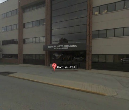
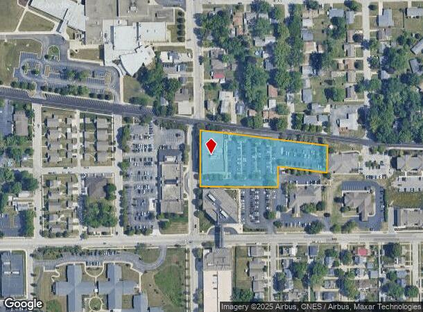
Property Record
415 N 26Th St, Lafayette, IN 47904
NEARBY LISTINGS FOR SALE OR LEASE
Property Detail
415 N 26Th St
79-07-22-355-002.000-004
PT SW SW SEC 22 TWP 23 R4 0.848 A & 0.960 A & 0.700 A
Medicalbuilding
Tippecanoe
X
Indiana
18157C0161D
1
2024
2.51 AC
2024
Lafayette/Kokomo
000700
Other Market Areas
66,000 SF
Lafayette-West Lafayette, IN
DEMOGRAPHICS near 415 N 26Th St
1 Mile
3 Mile
5 Mile
2024 Total Population
12,004
81,239
137,367
2029 Population
12,359
83,647
141,610
Pop Growth 2024-2029
+ 2.96%
+ 2.96%
+ 3.09%
Average Age
38
34
35
2024 Total Households
5,244
33,705
55,333
HH Growth 2024-2029
+ 3.05%
+ 3.32%
+ 3.42%
Median Household Inc
$42,046
$40,660
$48,137
Avg Household Size
2.10
2.10
2.20
2024 Avg HH Vehicles
1.00
2.00
2.00
Median Home Value
$120,160
$148,494
$182,312
Median Year Built
1949
1971
1982
Nearby Places
Map Layers
Map Styles
 Street
 Aerial
- Restaurants
- Banks
- Shops
- Fitness
- Groceries
Nearby Properties
Address
Land Use
TOTAL SIZE
Lot Size
Zoning
Address
Land Use
TOTAL SIZE
Lot Size
Zoning
469,872 SF
0.85 AC
Address
Land Use
TOTAL SIZE
Lot Size
Zoning
377,937 SF
4.80 AC
Address
Land Use
TOTAL SIZE
Lot Size
Zoning
68,943 SF
0.01 AC
Address
Land Use
TOTAL SIZE
Lot Size
Zoning
385,162 SF
1 AC
Address
Land Use
TOTAL SIZE
Lot Size
Zoning
401,345 SF
1.64 AC
Address
Land Use
TOTAL SIZE
Lot Size
Zoning
498,665 SF
1.94 AC
Address
Land Use
TOTAL SIZE
Lot Size
Zoning
Address
Land Use
TOTAL SIZE
Lot Size
Zoning
249,214 SF
1.93 AC
Address
Land Use
TOTAL SIZE
Lot Size
Zoning
117,351 SF
44 SF
Address
Land Use
TOTAL SIZE
Lot Size
Zoning
300,876 SF
20.47 AC
Address
Land Use
TOTAL SIZE
Lot Size
Zoning
210,829 SF
87 SF
Address
Land Use
TOTAL SIZE
Lot Size
Zoning
232,565 SF
1.15 AC
Address
Land Use
TOTAL SIZE
Lot Size
Zoning
1,449,360 SF
0.01 AC
Address
Land Use
TOTAL SIZE
Lot Size
Zoning
205,701 SF
1.27 AC
Address
Land Use
TOTAL SIZE
Lot Size
Zoning
77,226 SF
0.01 AC
Address
Land Use
TOTAL SIZE
Lot Size
Zoning
27,300 SF
22.52 AC
Address
Land Use
TOTAL SIZE
Lot Size
Zoning
164,234 SF
0.88 AC
Address
Land Use
TOTAL SIZE
Lot Size
Zoning
184,441 SF
44 SF
Address
Land Use
TOTAL SIZE
Lot Size
Zoning
222,276 SF
0.31 AC
Address
Land Use
TOTAL SIZE
Lot Size
Zoning
518,808 SF
174 SF
Address
Land Use
TOTAL SIZE
Lot Size
Zoning
140,973 SF
131 SF
Address
Land Use
TOTAL SIZE
Lot Size
Zoning
141,960 SF
2.27 AC
Address
Land Use
TOTAL SIZE
Lot Size
Zoning
118,066 SF
0.80 AC
Address
Land Use
TOTAL SIZE
Lot Size
Zoning
25,476 SF
131 SF
Address
Land Use
TOTAL SIZE
Lot Size
Zoning
135,090 SF
0.80 AC
Address
Land Use
TOTAL SIZE
Lot Size
Zoning
70,686 SF
25.67 AC
Address
Land Use
TOTAL SIZE
Lot Size
Zoning
1,409,410 SF
170.04 AC
Address
Land Use
TOTAL SIZE
Lot Size
Zoning
235,028 SF
131 SF
Address
Land Use
TOTAL SIZE
Lot Size
Zoning
109,515 SF
0.85 AC
The World's #1 Commercial Real Estate Marketplace
Connect with us
© 2026 CoStar Group
The information above has been obtained from sources believed reliable. While we do not doubt its accuracy we have not verified it and make no guarantee, warranty or representation about it. It is your responsibility to independently confirm its accuracy and completeness. Any projections, opinions, assumptions, or estimates used are for example only and do not represent the current or future performance of the property. The value of this transaction to you depends on tax and other factors which should be evaluated by your tax, financial, and legal advisors. You and your advisors should conduct a careful, independent investigation of the property to determine to your satisfaction the suitability of the property for your needs.