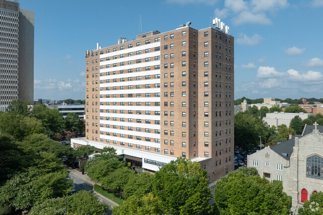
Property Record
415 N Main St, Greenville, SC 29601
NEARBY LISTINGS FOR SALE OR LEASE
Property Detail
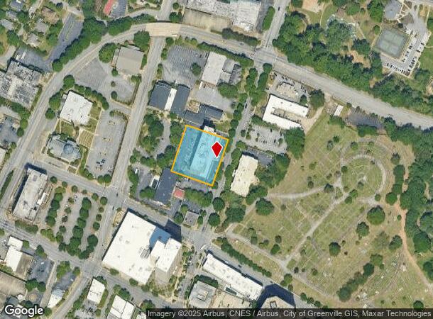
415 N Main St
Greenville-Anderson-Mauldin, SC
Alta Acsm Land Title Survey For Towers E
0003.00-02-021.00
MAP 0003.00
Apartment
Greenville
X
South Carolina
45045C0382E
021.00
2024
1.01 AC
2024
West Downtown
001000
Greenville/Spartanburg
DEMOGRAPHICS near 415 N Main St
1 Mile
3 Mile
5 Mile
2024 Total Population
13,274
91,466
178,062
2029 Population
15,011
102,048
197,525
Pop Growth 2024-2029
+ 13.09%
+ 11.57%
+ 10.93%
Average Age
41
38
39
2024 Total Households
6,591
39,159
76,087
HH Growth 2024-2029
+ 13.69%
+ 11.82%
+ 11.11%
Median Household Inc
$79,489
$53,742
$54,744
Avg Household Size
1.80
2.20
2.20
2024 Avg HH Vehicles
1.00
2.00
2.00
Median Home Value
$456,796
$286,968
$254,142
Median Year Built
2003
1976
1978
Nearby Places
Map Layers
Map Styles
 Street
 Aerial
- Restaurants
- Banks
- Shops
- Fitness
- Groceries
PUBLIC TRANSPORTATION
COMMUTER RAIL
Greenville Amtrak Station (Crescent - Amtrak)
DRIVE
WALK
Distance
Greenville Amtrak Station (Crescent - Amtrak)
3 min
1.5 mi
AIRPORT
Greenville Spartanburg International
DRIVE
WALK
Distance
Greenville Spartanburg International
22 min
14.0 mi
Freight Ports
North Charleston Terminal
DRIVE
WALK
Distance
North Charleston Terminal
229 min
204.6 mi
Nearby Properties
Address
Land Use
TOTAL SIZE
Lot Size
Zoning
Address
Land Use
TOTAL SIZE
Lot Size
Zoning
14.21 AC
RM2
Address
Land Use
TOTAL SIZE
Lot Size
Zoning
0.45 AC
OD
Address
Land Use
TOTAL SIZE
Lot Size
Zoning
14.41 AC
RM2
Address
Land Use
TOTAL SIZE
Lot Size
Zoning
11.99 AC
RM2
Address
Land Use
TOTAL SIZE
Lot Size
Zoning
11.82 AC
RM2
Address
Land Use
TOTAL SIZE
Lot Size
Zoning
8.94 AC
RM2
Address
Land Use
TOTAL SIZE
Lot Size
Zoning
7.03 AC
OD
Address
Land Use
TOTAL SIZE
Lot Size
Zoning
0.39 AC
C4
Address
Land Use
TOTAL SIZE
Lot Size
Zoning
9.13 AC
RM2
Address
Land Use
TOTAL SIZE
Lot Size
Zoning
10.59 AC
RM2
Address
Land Use
TOTAL SIZE
Lot Size
Zoning
28.88 AC
RM
Address
Land Use
TOTAL SIZE
Lot Size
Zoning
28.72 AC
C3
Address
Land Use
TOTAL SIZE
Lot Size
Zoning
0.47 AC
OD
Address
Land Use
TOTAL SIZE
Lot Size
Zoning
5.61 AC
RM2
Address
Land Use
TOTAL SIZE
Lot Size
Zoning
9.91 AC
C3
Address
Land Use
TOTAL SIZE
Lot Size
Zoning
6.17 AC
Address
Land Use
TOTAL SIZE
Lot Size
Zoning
114.75 AC
0D
Address
Land Use
TOTAL SIZE
Lot Size
Zoning
6.21 AC
C3
Address
Land Use
TOTAL SIZE
Lot Size
Zoning
1.92 AC
C4
Address
Land Use
TOTAL SIZE
Lot Size
Zoning
6.03 AC
OD
Address
Land Use
TOTAL SIZE
Lot Size
Zoning
20.04 AC
RM
Address
Land Use
TOTAL SIZE
Lot Size
Zoning
0.65 AC
OD
Address
Land Use
TOTAL SIZE
Lot Size
Zoning
0.53 AC
C4
Address
Land Use
TOTAL SIZE
Lot Size
Zoning
1.62 AC
C3
Address
Land Use
TOTAL SIZE
Lot Size
Zoning
11.13 AC
OD
Address
Land Use
TOTAL SIZE
Lot Size
Zoning
5.86 AC
RM2
Address
Land Use
TOTAL SIZE
Lot Size
Zoning
1.19 AC
C4
Address
Land Use
TOTAL SIZE
Lot Size
Zoning
47.64 AC
R6
Address
Land Use
TOTAL SIZE
Lot Size
Zoning
4.67 AC
C3
The World's #1 Commercial Real Estate Marketplace
Connect with us
© 2026 CoStar Group
The information above has been obtained from sources believed reliable. While we do not doubt its accuracy we have not verified it and make no guarantee, warranty or representation about it. It is your responsibility to independently confirm its accuracy and completeness. Any projections, opinions, assumptions, or estimates used are for example only and do not represent the current or future performance of the property. The value of this transaction to you depends on tax and other factors which should be evaluated by your tax, financial, and legal advisors. You and your advisors should conduct a careful, independent investigation of the property to determine to your satisfaction the suitability of the property for your needs.