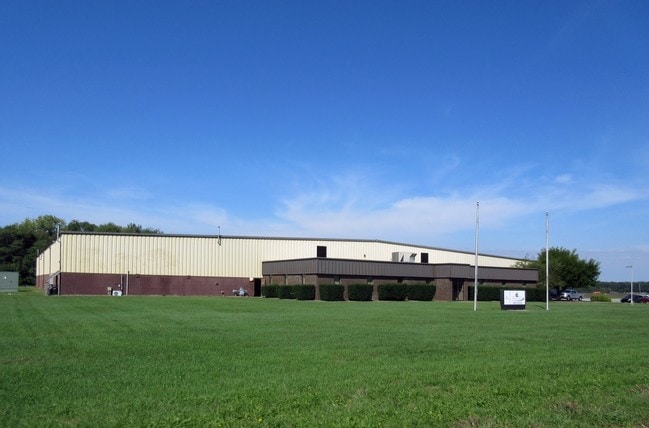
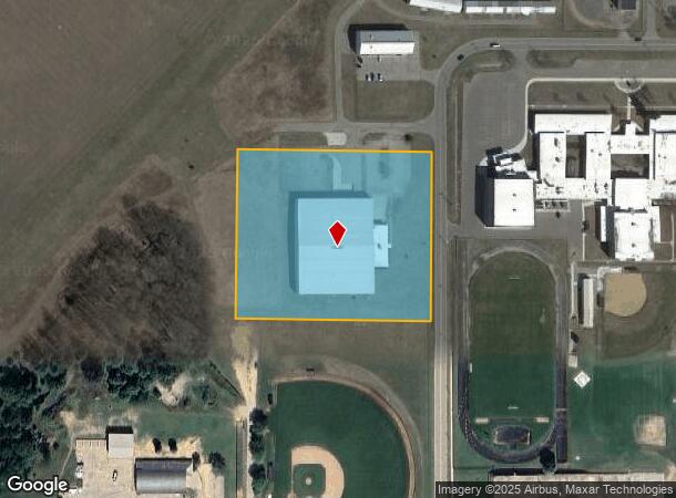
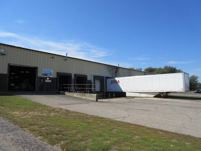
Property Record
415 N Paul St, Dowagiac, MI 49047

NEARBY LISTINGS FOR SALE OR LEASE
-
-
View all Dowagiac listings for lease on LoopNet.com
Property Detail
415 N Paul St
14-160-200-194-11
DW 345 A-1 COM E 1243.94 FT & S 0 DEG 27' 13E 263 FT FRM W 1/4 COR, TH S 0 DEG 27' 13E 456.13 FT, S 89 DEG 32'47W 519.93
Industrialgeneral
Cass
X
Michigan
26027C0130C
193
2024
5.46 AC
2025
Cass County
001901
South Bend/Mishawaka
54,470 SF
South Bend-Mishawaka, IN-MI
DEMOGRAPHICS near 415 N Paul St
1 Mile
3 Mile
5 Mile
2024 Total Population
3,716
7,754
11,087
2029 Population
3,677
7,647
10,990
Pop Growth 2024-2029
(1.05%)
(1.38%)
(0.87%)
Average Age
40
39
40
2024 Total Households
1,490
3,064
4,386
HH Growth 2024-2029
(1.07%)
(1.47%)
(0.91%)
Median Household Inc
$52,131
$47,694
$51,042
Avg Household Size
2.40
2.40
2.40
2024 Avg HH Vehicles
2.00
2.00
2.00
Median Home Value
$119,199
$112,406
$131,760
Median Year Built
1949
1960
1965
Nearby Places
Map Layers
Map Styles
 Street
 Aerial
- Restaurants
- Banks
- Shops
- Fitness
- Groceries
PUBLIC TRANSPORTATION
COMMUTER RAIL
Dowagiac Amtrak Station (Blue Water - Amtrak, Wolverine - Amtrak)
DRIVE
WALK
Distance
Dowagiac Amtrak Station (Blue Water - Amtrak, Wolverine - Amtrak)
3 min
1.2 mi
AIRPORT
South Bend International
DRIVE
WALK
Distance
South Bend International
52 min
28.4 mi
Freight Ports
Port Milwaukee
DRIVE
WALK
Distance
Port Milwaukee
247 min
197.8 mi
SALE & LEASE HISTORY
LISTING DATE
SALE/LEASE

May 06, 2021
For Lease
May 06, 2021
For Sale
May 04, 2017
For Lease
Mar 26, 2021
For Lease
Jul 28, 2017
For Lease
Jan 19, 2017
For Sale
Nearby Properties
Address
Land Use
TOTAL SIZE
Lot Size
Zoning
Address
Land Use
TOTAL SIZE
Lot Size
Zoning
57,900 SF
9.80 AC
Address
Land Use
TOTAL SIZE
Lot Size
Zoning
47,544 SF
10,587 AC
Address
Land Use
TOTAL SIZE
Lot Size
Zoning
596,999 SF
34.19 AC
Address
Land Use
TOTAL SIZE
Lot Size
Zoning
383,513 SF
28.36 AC
Address
Land Use
TOTAL SIZE
Lot Size
Zoning
31,900 SF
Address
Land Use
TOTAL SIZE
Lot Size
Zoning
34,984 SF
4.41 AC
Address
Land Use
TOTAL SIZE
Lot Size
Zoning
150,916 SF
24.79 AC
Address
Land Use
TOTAL SIZE
Lot Size
Zoning
31,935 SF
3.96 AC
Address
Land Use
TOTAL SIZE
Lot Size
Zoning
36,980 SF
4.19 AC
Address
Land Use
TOTAL SIZE
Lot Size
Zoning
27,996 SF
10.96 AC
Address
Land Use
TOTAL SIZE
Lot Size
Zoning
18,750 SF
4.81 AC
Address
Land Use
TOTAL SIZE
Lot Size
Zoning
97,346 SF
4.70 AC
Address
Land Use
TOTAL SIZE
Lot Size
Zoning
27,946 SF
2.43 AC
Address
Land Use
TOTAL SIZE
Lot Size
Zoning
22,712 SF
0.80 AC
Address
Land Use
TOTAL SIZE
Lot Size
Zoning
45,426 SF
2.10 AC
Address
Land Use
TOTAL SIZE
Lot Size
Zoning
19,840 SF
2.41 AC
Address
Land Use
TOTAL SIZE
Lot Size
Zoning
10,376 SF
20.80 AC
Address
Land Use
TOTAL SIZE
Lot Size
Zoning
240 AC
Address
Land Use
TOTAL SIZE
Lot Size
Zoning
24,748 SF
1.29 AC
Address
Land Use
TOTAL SIZE
Lot Size
Zoning
148.26 AC
Address
Land Use
TOTAL SIZE
Lot Size
Zoning
16,544 SF
3.40 AC
Address
Land Use
TOTAL SIZE
Lot Size
Zoning
3,452 SF
54.55 AC
Address
Land Use
TOTAL SIZE
Lot Size
Zoning
5,396 SF
101.83 AC
Address
Land Use
TOTAL SIZE
Lot Size
Zoning
21,818 SF
1.58 AC
Address
Land Use
TOTAL SIZE
Lot Size
Zoning
157.16 AC
Address
Land Use
TOTAL SIZE
Lot Size
Zoning
25,592 SF
1.40 AC
Address
Land Use
TOTAL SIZE
Lot Size
Zoning
30,192 SF
2.15 AC
Address
Land Use
TOTAL SIZE
Lot Size
Zoning
7,512 SF
1.06 AC
Address
Land Use
TOTAL SIZE
Lot Size
Zoning
9,846 SF
0.34 AC
The World's #1 Commercial Real Estate Marketplace
Connect with us
© 2026 CoStar Group
The information above has been obtained from sources believed reliable. While we do not doubt its accuracy we have not verified it and make no guarantee, warranty or representation about it. It is your responsibility to independently confirm its accuracy and completeness. Any projections, opinions, assumptions, or estimates used are for example only and do not represent the current or future performance of the property. The value of this transaction to you depends on tax and other factors which should be evaluated by your tax, financial, and legal advisors. You and your advisors should conduct a careful, independent investigation of the property to determine to your satisfaction the suitability of the property for your needs.