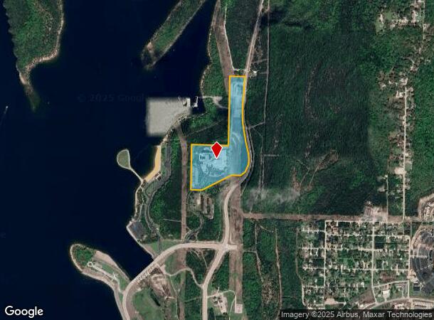
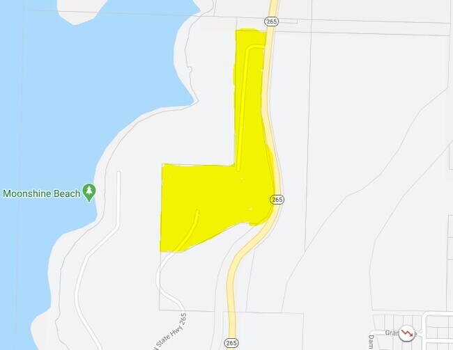
Property Record
415 State Highway 265, Branson, MO 65616

NEARBY LISTINGS FOR SALE OR LEASE
Property Detail
415 State Highway 265
Branson, MO
City Of Branson
18-5.0-15-000-000-005.000
PT E2NW4 W OF MSH 265; CITY OF BRANSON
Commercialnec
Taney
2024
Missouri
2025
21.35 AC
480107
Branson
107,469 SF
Other Market Areas
DEMOGRAPHICS near 415 State Highway 265
1 Mile
3 Mile
5 Mile
2024 Total Population
986
12,385
23,722
2029 Population
1,074
13,349
25,383
Pop Growth 2024-2029
+ 8.92%
+ 7.78%
+ 7.00%
Average Age
45
46
45
2024 Total Households
409
5,664
9,875
HH Growth 2024-2029
+ 9.05%
+ 7.66%
+ 7.27%
Median Household Inc
$68,881
$53,963
$54,343
Avg Household Size
2.30
2.10
2.20
2024 Avg HH Vehicles
2.00
2.00
2.00
Median Home Value
$149,691
$178,278
$198,894
Median Year Built
1996
1996
1996
Nearby Places
Map Layers
Map Styles
 Street
 Aerial
- Restaurants
- Banks
- Shops
- Fitness
- Groceries
Nearby Properties
Address
Land Use
TOTAL SIZE
Lot Size
Zoning
Address
Land Use
TOTAL SIZE
Lot Size
Zoning
26,658 SF
6.30 AC
Address
Land Use
TOTAL SIZE
Lot Size
Zoning
18,781 SF
4.70 AC
Address
Land Use
TOTAL SIZE
Lot Size
Zoning
27,496 SF
3.34 AC
Address
Land Use
TOTAL SIZE
Lot Size
Zoning
12,542 SF
3.87 AC
Address
Land Use
TOTAL SIZE
Lot Size
Zoning
32,464 SF
2.16 AC
Address
Land Use
TOTAL SIZE
Lot Size
Zoning
45,680 SF
11.85 AC
Address
Land Use
TOTAL SIZE
Lot Size
Zoning
55,651 SF
3.95 AC
Address
Land Use
TOTAL SIZE
Lot Size
Zoning
85,644 SF
6.64 AC
Address
Land Use
TOTAL SIZE
Lot Size
Zoning
17,313 SF
5.18 AC
Address
Land Use
TOTAL SIZE
Lot Size
Zoning
39,644 SF
7.02 AC
Address
Land Use
TOTAL SIZE
Lot Size
Zoning
14,616 SF
1.97 AC
Address
Land Use
TOTAL SIZE
Lot Size
Zoning
20,617 SF
2.18 AC
Address
Land Use
TOTAL SIZE
Lot Size
Zoning
10,783 SF
0.32 AC
Address
Land Use
TOTAL SIZE
Lot Size
Zoning
22,568 SF
6.60 AC
Address
Land Use
TOTAL SIZE
Lot Size
Zoning
10,783 SF
0.33 AC
Address
Land Use
TOTAL SIZE
Lot Size
Zoning
29,477 SF
3.97 AC
Address
Land Use
TOTAL SIZE
Lot Size
Zoning
10,783 SF
0.33 AC
Address
Land Use
TOTAL SIZE
Lot Size
Zoning
28,066 SF
4.87 AC
Address
Land Use
TOTAL SIZE
Lot Size
Zoning
30,941 SF
4.78 AC
Address
Land Use
TOTAL SIZE
Lot Size
Zoning
53,508 SF
113 AC
Address
Land Use
TOTAL SIZE
Lot Size
Zoning
198,211 SF
36.32 AC
Address
Land Use
TOTAL SIZE
Lot Size
Zoning
24,722 SF
2.22 AC
Address
Land Use
TOTAL SIZE
Lot Size
Zoning
21,501 SF
4.16 AC
Address
Land Use
TOTAL SIZE
Lot Size
Zoning
26,756 SF
11.55 AC
Address
Land Use
TOTAL SIZE
Lot Size
Zoning
9,841 SF
0.23 AC
Address
Land Use
TOTAL SIZE
Lot Size
Zoning
47,126 SF
5.35 AC
Address
Land Use
TOTAL SIZE
Lot Size
Zoning
18,652 SF
2.37 AC
Address
Land Use
TOTAL SIZE
Lot Size
Zoning
23,901 SF
2.92 AC
Address
Land Use
TOTAL SIZE
Lot Size
Zoning
12,444 SF
1.45 AC
The World's #1 Commercial Real Estate Marketplace
Connect with us
© 2025 CoStar Group
The information above has been obtained from sources believed reliable. While we do not doubt its accuracy we have not verified it and make no guarantee, warranty or representation about it. It is your responsibility to independently confirm its accuracy and completeness. Any projections, opinions, assumptions, or estimates used are for example only and do not represent the current or future performance of the property. The value of this transaction to you depends on tax and other factors which should be evaluated by your tax, financial, and legal advisors. You and your advisors should conduct a careful, independent investigation of the property to determine to your satisfaction the suitability of the property for your needs.