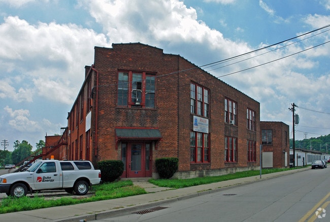
Property Record
415 W Seymour Ave, Cincinnati, OH 45216

NEARBY LISTINGS FOR SALE OR LEASE
Property Detail
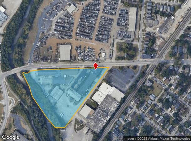
415 W Seymour Ave
239-0003-0005
SS WEST SEYMOUR AVE 6.348 ACSR2-T3-S12 SW COR MORTON RD & C H D
Warehouse
Hamilton
AE
Ohio
39061C0228E
6.35 AC
2024
Central/Midtown
2024
Cincinnati/Dayton
006100
Cincinnati, OH-KY-IN
DEMOGRAPHICS near 415 W Seymour Ave
1 Mile
3 Mile
5 Mile
2024 Total Population
5,539
90,323
284,940
2029 Population
5,431
89,092
283,407
Pop Growth 2024-2029
(1.95%)
(1.36%)
(0.54%)
Average Age
38
40
38
2024 Total Households
2,262
38,793
123,923
HH Growth 2024-2029
(2.17%)
(1.42%)
(0.68%)
Median Household Inc
$38,049
$53,957
$52,864
Avg Household Size
2.40
2.20
2.10
2024 Avg HH Vehicles
2.00
2.00
2.00
Median Home Value
$81,409
$167,068
$181,355
Median Year Built
1946
1952
1953
Nearby Places
Map Layers
Map Styles
 Street
 Aerial
- Restaurants
- Banks
- Shops
- Fitness
- Groceries
PUBLIC TRANSPORTATION
COMMUTER RAIL
Cincinnati Union Terminal (Cardinal - Amtrak)
DRIVE
WALK
Distance
Cincinnati Union Terminal (Cardinal - Amtrak)
15 min
9.1 mi
AIRPORT
Cincinnati/Northern Kentucky International
DRIVE
WALK
Distance
Cincinnati/Northern Kentucky International
39 min
23.2 mi
Freight Ports
Port of Toledo
DRIVE
WALK
Distance
Port of Toledo
231 min
198.0 mi
Nearby Properties
Address
Land Use
TOTAL SIZE
Lot Size
Zoning
Address
Land Use
TOTAL SIZE
Lot Size
Zoning
21.34 AC
Address
Land Use
TOTAL SIZE
Lot Size
Zoning
2.49 AC
DD
Address
Land Use
TOTAL SIZE
Lot Size
Zoning
6.34 AC
Address
Land Use
TOTAL SIZE
Lot Size
Zoning
29.67 AC
RM20
Address
Land Use
TOTAL SIZE
Lot Size
Zoning
11,639 SF
7.87 AC
R2
Address
Land Use
TOTAL SIZE
Lot Size
Zoning
14.15 AC
Address
Land Use
TOTAL SIZE
Lot Size
Zoning
23.45 AC
Address
Land Use
TOTAL SIZE
Lot Size
Zoning
330,335 SF
0.80 AC
R3
Address
Land Use
TOTAL SIZE
Lot Size
Zoning
42.41 AC
Address
Land Use
TOTAL SIZE
Lot Size
Zoning
344,923 SF
18.47 AC
RM20
Address
Land Use
TOTAL SIZE
Lot Size
Zoning
Address
Land Use
TOTAL SIZE
Lot Size
Zoning
13.08 AC
Address
Land Use
TOTAL SIZE
Lot Size
Zoning
210,743 SF
0.35 AC
DD
Address
Land Use
TOTAL SIZE
Lot Size
Zoning
20.07 AC
B2
Address
Land Use
TOTAL SIZE
Lot Size
Zoning
2.22 AC
Address
Land Use
TOTAL SIZE
Lot Size
Zoning
4.14 AC
M2PUD
Address
Land Use
TOTAL SIZE
Lot Size
Zoning
437,072 SF
8.03 AC
R2
Address
Land Use
TOTAL SIZE
Lot Size
Zoning
Address
Land Use
TOTAL SIZE
Lot Size
Zoning
88.15 AC
ML
Address
Land Use
TOTAL SIZE
Lot Size
Zoning
11,664 SF
29.27 AC
RM20
Address
Land Use
TOTAL SIZE
Lot Size
Zoning
Address
Land Use
TOTAL SIZE
Lot Size
Zoning
17,758 SF
7 AC
RM20
Address
Land Use
TOTAL SIZE
Lot Size
Zoning
8,720 SF
33.28 AC
R3
Address
Land Use
TOTAL SIZE
Lot Size
Zoning
60,614 SF
13.35 AC
SF6
Address
Land Use
TOTAL SIZE
Lot Size
Zoning
38,102 SF
6.26 AC
SF10
Address
Land Use
TOTAL SIZE
Lot Size
Zoning
Address
Land Use
TOTAL SIZE
Lot Size
Zoning
121,747 SF
23.05 AC
R3
Address
Land Use
TOTAL SIZE
Lot Size
Zoning
4.06 AC
M2PUD
Address
Land Use
TOTAL SIZE
Lot Size
Zoning
9.51 AC
Address
Land Use
TOTAL SIZE
Lot Size
Zoning
38,680 SF
7.07 AC
RM20
The World's #1 Commercial Real Estate Marketplace
Connect with us
© 2025 CoStar Group
The information above has been obtained from sources believed reliable. While we do not doubt its accuracy we have not verified it and make no guarantee, warranty or representation about it. It is your responsibility to independently confirm its accuracy and completeness. Any projections, opinions, assumptions, or estimates used are for example only and do not represent the current or future performance of the property. The value of this transaction to you depends on tax and other factors which should be evaluated by your tax, financial, and legal advisors. You and your advisors should conduct a careful, independent investigation of the property to determine to your satisfaction the suitability of the property for your needs.