Property Record
4150 Keller Rd, Holt, MI 48842


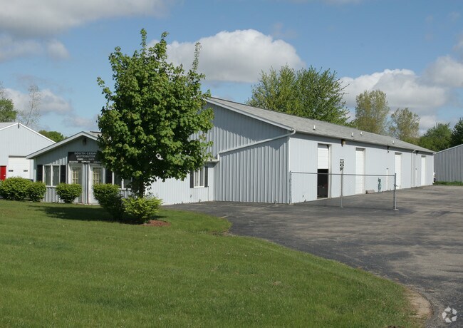
Property Detail
4150 Keller Rd
25-05-14-252-016
W 104.74 FT OF LOT 9 PINE TREE INDUSTRIAL PARK, ALSO PT OF LOT 10 BEG @ NE COR LOT 10, TH S23?31'34E 207.88 FT ALG RR R/W TO SE COR LOT 10
Warehouse
Ingham
IP
Michigan
B and X Area of moderate flood hazard, usually the area between the limits of the 100-year and 500-year floods.
9-10
2024
1.92 AC
2025
Southern Lansing
005402
West Michigan
7,296 SF
Lansing-East Lansing, MI
NEARBY LISTINGS FOR SALE OR LEASE
DEMOGRAPHICS near 4150 Keller Rd
1 mile
3 mile
5 mile
2025 Total Population
8,418
35,530
81,721
2030 Population
8,459
35,987
82,887
Pop Growth 2025-2030
+ 0.49%
+ 1.29%
+ 1.43%
Average Age
40
39
38
2025 Total Households
3,754
15,565
34,437
HH Growth 2025-2030
+ 0.77%
+ 1.41%
+ 1.39%
Median Household Inc
$71,183
$66,539
$64,200
Avg Household Size
2.20
2.20
2.30
2025 Avg HH Vehicles
2.00
2.00
2.00
Median Home Value
$179,749
$188,506
$168,606
Median Year Built
1976
1977
1973
Nearby Places
Map Layers
Map Styles
 Street
 Aerial
Transit
 Traffic
 Biking
Places
Listings with unknown addresses are not visible on the map
- Restaurants
- Banks
- Shops
- Fitness
- Groceries
PUBLIC TRANSPORTATION
COMMUTER RAIL
East Lansing Amtrak Station (Blue Water - Amtrak)
Drive
Walk
Distance
East Lansing Amtrak Station (Blue Water - Amtrak)
15 min
9.1 mi
AIRPORT
Capital Region International
Drive
Walk
Distance
Capital Region International
22 min
11.5 mi
Freight Ports
Port of Toledo
Drive
Walk
Distance
Port of Toledo
140 min
107.5 mi
Nearby Properties
Address
Land Use
TOTAL SIZE
Lot Size
Zoning
Address
Land Use
TOTAL SIZE
Lot Size
Zoning
49,336 SF
9.60 AC
F COMM
Address
Land Use
TOTAL SIZE
Lot Size
Zoning
21,447 SF
56.20 AC
RM
Address
Land Use
TOTAL SIZE
Lot Size
Zoning
3,246 SF
13.54 AC
DM-1 RE
Address
Land Use
TOTAL SIZE
Lot Size
Zoning
178,096 SF
22.80 AC
IP
Address
Land Use
TOTAL SIZE
Lot Size
Zoning
2,920 SF
36.77 AC
CUP
Address
Land Use
TOTAL SIZE
Lot Size
Zoning
410 AC
Address
Land Use
TOTAL SIZE
Lot Size
Zoning
912 SF
20.97 AC
RM
Address
Land Use
TOTAL SIZE
Lot Size
Zoning
8,857 SF
21.22 AC
A RESID
Address
Land Use
TOTAL SIZE
Lot Size
Zoning
31,215 SF
19.19 AC
CUP
Address
Land Use
TOTAL SIZE
Lot Size
Zoning
7,868 SF
12.03 AC
RM
Address
Land Use
TOTAL SIZE
Lot Size
Zoning
8,341 SF
27.70 AC
RM
Address
Land Use
TOTAL SIZE
Lot Size
Zoning
23,940 SF
13.44 AC
CUP
Address
Land Use
TOTAL SIZE
Lot Size
Zoning
616,146 SF
111.68 AC
IP
Address
Land Use
TOTAL SIZE
Lot Size
Zoning
17,920 SF
208 AC
Address
Land Use
TOTAL SIZE
Lot Size
Zoning
351 SF
20.90 AC
Address
Land Use
TOTAL SIZE
Lot Size
Zoning
1,642 SF
288 AC
DM-1 RE
Address
Land Use
TOTAL SIZE
Lot Size
Zoning
10,112 SF
12.57 AC
RM-1
Address
Land Use
TOTAL SIZE
Lot Size
Zoning
47,352 SF
2.41 AC
TC
Address
Land Use
TOTAL SIZE
Lot Size
Zoning
14,981 SF
12.66 AC
R-1E
Address
Land Use
TOTAL SIZE
Lot Size
Zoning
75,476 SF
17.70 AC
Address
Land Use
TOTAL SIZE
Lot Size
Zoning
168,480 SF
15.30 AC
G-2 WHO
Address
Land Use
TOTAL SIZE
Lot Size
Zoning
3,528 SF
230 AC
Address
Land Use
TOTAL SIZE
Lot Size
Zoning
80,080 SF
7.91 AC
D-1 PRO
Address
Land Use
TOTAL SIZE
Lot Size
Zoning
Address
Land Use
TOTAL SIZE
Lot Size
Zoning
29,808 SF
9.66 AC
CUP
Address
Land Use
TOTAL SIZE
Lot Size
Zoning
72,722 SF
3.99 AC
A-1 RES
Address
Land Use
TOTAL SIZE
Lot Size
Zoning
16,913 SF
11.25 AC
R-1E
Address
Land Use
TOTAL SIZE
Lot Size
Zoning
15,439 SF
13.13 AC
R-1E
Address
Land Use
TOTAL SIZE
Lot Size
Zoning
26,042 SF
3.58 AC
C-2
Address
Land Use
TOTAL SIZE
Lot Size
Zoning
164 AC
The World's #1 Commercial Real Estate Marketplace
Connect with us
© 2026 CoStar Group
The information above has been obtained from sources believed reliable. While we do not doubt its accuracy we have not verified it and make no guarantee, warranty or representation about it. It is your responsibility to independently confirm its accuracy and completeness. Any projections, opinions, assumptions, or estimates used are for example only and do not represent the current or future performance of the property. The value of this transaction to you depends on tax and other factors which should be evaluated by your tax, financial, and legal advisors. You and your advisors should conduct a careful, independent investigation of the property to determine to your satisfaction the suitability of the property for your needs.