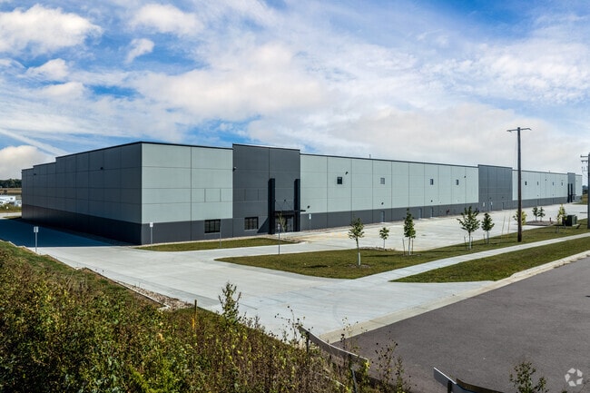
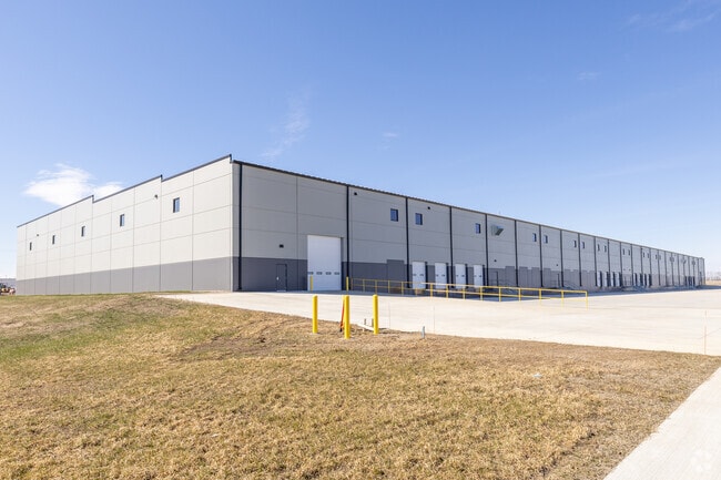
Property Record
4150 W 62Nd St N, Sioux Falls, SD 57107


Save to a Folder
{{folder.Name}}
{{folder.ListingIds.length}} Properties
{{folder.ListingIds.length}} Property
Create a New Folder
This Property Is For Sale
Current Lease Availabilities
Property Detail
4150 W 62Nd St N
96824
LOT 2 BLOCK 1 GRIFFITH PARK ADDITION TO THE CITY OF SIOUX FALLS
Distributionwarehouseregional
MINNEHAHA
I1;LIGHT I
South Dakota
B and X Area of moderate flood hazard, usually the area between the limits of the 100-year and 500-year floods.
2
2025
11.65 AC
2025
Sioux Falls
010405
Other Market Areas
145,200 SF
Sioux Falls, SD-MN
NEARBY LISTINGS FOR SALE OR LEASE
DEMOGRAPHICS near 4150 W 62Nd St N
1 mile
3 mile
5 mile
2025 Total Population
569
6,661
45,288
2030 Population
635
7,180
47,782
Pop Growth 2025-2030
+ 11.60%
+ 7.79%
+ 5.51%
Average Age
40
34
38
2025 Total Households
236
2,763
18,883
HH Growth 2025-2030
+ 11.86%
+ 8.29%
+ 6.05%
Median Household Inc
$71,363
$71,510
$63,188
Avg Household Size
2.30
2.30
2.20
2025 Avg HH Vehicles
2.00
2.00
2.00
Median Home Value
$317,164
$309,224
$219,566
Median Year Built
2010
2010
1989
Nearby Places
Map Layers
Map Styles
 Street
 Aerial
Layers
 Traffic
 Biking
Places
Listings with unknown addresses are not visible on the map
- Restaurants
- Banks
- Shops
- Fitness
- Groceries
PUBLIC TRANSPORTATION
AIRPORT
Joe Foss Field
Drive
Walk
Distance
Joe Foss Field
24 min
7.2 mi
Freight Ports
Port Milwaukee
Drive
Walk
Distance
Port Milwaukee
547 min
504.1 mi
Nearby Properties
Address
Land Use
TOTAL SIZE
Lot Size
Zoning
Address
Land Use
TOTAL SIZE
Lot Size
Zoning
2,596,487 SF
80.61 AC
Address
Land Use
TOTAL SIZE
Lot Size
Zoning
195,766 SF
47.93 AC
Address
Land Use
TOTAL SIZE
Lot Size
Zoning
349,950 SF
32.99 AC
Address
Land Use
TOTAL SIZE
Lot Size
Zoning
340,204 SF
36.85 AC
Address
Land Use
TOTAL SIZE
Lot Size
Zoning
199,500 SF
29.45 AC
Address
Land Use
TOTAL SIZE
Lot Size
Zoning
140,816 SF
13.80 AC
Address
Land Use
TOTAL SIZE
Lot Size
Zoning
Address
Land Use
TOTAL SIZE
Lot Size
Zoning
77,853 SF
10.42 AC
Address
Land Use
TOTAL SIZE
Lot Size
Zoning
36,986 SF
8.49 AC
FP;FP
Address
Land Use
TOTAL SIZE
Lot Size
Zoning
195,113 SF
34.68 AC
Address
Land Use
TOTAL SIZE
Lot Size
Zoning
200,880 SF
49.95 AC
C;COMMERCI
Address
Land Use
TOTAL SIZE
Lot Size
Zoning
35,688 SF
8.27 AC
FP;FP
Address
Land Use
TOTAL SIZE
Lot Size
Zoning
75,786 SF
7.14 AC
Address
Land Use
TOTAL SIZE
Lot Size
Zoning
105,638 SF
6.04 AC
Address
Land Use
TOTAL SIZE
Lot Size
Zoning
46,647 SF
14.22 AC
Address
Land Use
TOTAL SIZE
Lot Size
Zoning
137,609 SF
22.28 AC
Address
Land Use
TOTAL SIZE
Lot Size
Zoning
134,102 SF
11.77 AC
Address
Land Use
TOTAL SIZE
Lot Size
Zoning
189,312 SF
23.87 AC
Address
Land Use
TOTAL SIZE
Lot Size
Zoning
168,359 SF
9.65 AC
NO;SPECIAL
Address
Land Use
TOTAL SIZE
Lot Size
Zoning
Address
Land Use
TOTAL SIZE
Lot Size
Zoning
11,844 SF
7.22 AC
Address
Land Use
TOTAL SIZE
Lot Size
Zoning
105,048 SF
9.68 AC
Address
Land Use
TOTAL SIZE
Lot Size
Zoning
36,560 SF
43.19 AC
Address
Land Use
TOTAL SIZE
Lot Size
Zoning
58,825 SF
20.09 AC
Address
Land Use
TOTAL SIZE
Lot Size
Zoning
30,712 SF
2 AC
C;COMMERCI
Address
Land Use
TOTAL SIZE
Lot Size
Zoning
1.92 AC
C;COMMERCI
Address
Land Use
TOTAL SIZE
Lot Size
Zoning
85,272 SF
4.83 AC
Address
Land Use
TOTAL SIZE
Lot Size
Zoning
192,608 SF
16.53 AC
I1;LIGHT I
Address
Land Use
TOTAL SIZE
Lot Size
Zoning
1.84 AC
C;COMMERCI
The World's #1 Commercial Real Estate Marketplace
Connect with us
© 2026 CoStar Group
The information above has been obtained from sources believed reliable. While we do not doubt its accuracy we have not verified it and make no guarantee, warranty or representation about it. It is your responsibility to independently confirm its accuracy and completeness. Any projections, opinions, assumptions, or estimates used are for example only and do not represent the current or future performance of the property. The value of this transaction to you depends on tax and other factors which should be evaluated by your tax, financial, and legal advisors. You and your advisors should conduct a careful, independent investigation of the property to determine to your satisfaction the suitability of the property for your needs.